This item has been sold, but you can get on the Waitlist to be notified if another example becomes available, or purchase a digital scan.
1945 U.S. Navy Hydrographic Office Nautical Chart of the Singapore Strait
SingaporeStraitWestern-hydrographic-1945$475.00

Title
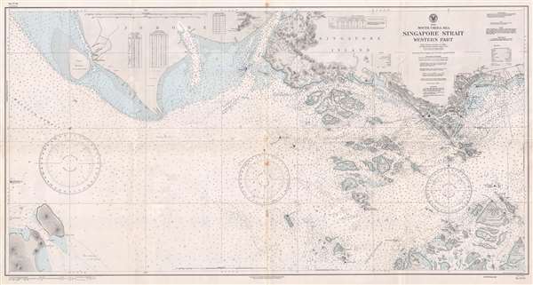
South China Sea Singapore Strait Western Part.
1945 (dated) 27 x 50.75 in (68.58 x 128.905 cm) 1 : 50000
1945 (dated) 27 x 50.75 in (68.58 x 128.905 cm) 1 : 50000
Description
This is a 1945 U.S. Navy Hydrographic Office nautical chart or maritime map of the Singapore Strait. The map depicts the region from the Malacca Strait to the city of Singapore and from Johore and Singapore Island to Great Karimon Island and several smaller islands south of Singapore. A detailed city plan of the city of Singapore is included, with numerous locations labeled within the city, including the aerodrome, the clock tower, and Fort Canning. Myriad depth soundings, measured in fathoms, are present throughout. Topographical features are illustrated on Singapore Island, along with several rivers and other physical features. Numerous regional islands are illustrated and labeled. Tables containing tidal information, the direction and rate of tidal currents, and conversions from fathoms to meters are situated along the top border.
The Singapore Strategy
As this map was being printed, Singapore became central to the Singapore Strategy, a naval defense policy instituted by the British Empire between 1919 and 1941. Following World War I (1914 – 1918), it became apparent that the Royal Navy was facing challenges to its long established supremacy by the rising naval forces of the United States and Imperial Japan. While the growing U.S. Navy, being a strong ally, was not a serious cause of concern, it quickly became apparent that the Imperial Japanese naval buildup would clash with British interests in the Far East.
The British determined to establish a 'Gibraltar of the East,' zoning in on Singapore for its exceptionally strategic position. Starting work in 1919, the British began a series of extensive improvements to the port as an expense of some 500,000 GBP. Completed over the subsequent 20 years, Singapore was outfitted with largest dry dock in the world, the third largest wet dock, and enough fuel tanks to support the entire Royal Navy for six months. The island's defenses also included an enormous Royal Air Force base and mounted 15-inch stationary guns. Despite what appeared to be highly defensible position, when hostilities finally broke out between the British Empire and Imperial Japan, in 1942, Singapore fell to Japanese invaders after just 15 days of fighting, an event described by Prime Minister Winston Churchill as the 'worst disaster and largest capitulation in British history.'
Created from British and Dutch surveys and charts, this chart was originally published by the U.S. Navy Hydrographic Office in May 1935. This example bears numerous small updates and corrections, made almost exclusively after the beginning of World War II. The last update dates from July 1945, two months before the end of World War II in the Pacific. At that time the Japanese still occupied Singapore and would until the end of the war in September.
Cartographer
United States Hydrographic Office (1866 - 1962) was a brach of he U.S. Navy that prepared and published maps, charts, and nautical books to aid in navigation. Before the establishment of the Hydrographic Office in 1866, U.S. navigators were almost entirely dependent on British charts. There had been a few private enterprises that had prepared and published charts, but none had been able to do so profitably. The Office was established 'for the improvement of the means of navigating safely the vessels of the Navy and of the mercantile marine, by providing, under the authority of the Secretary of the Navy, accurate and cheap nautical charts, sailing directions, navigators, and manuals of instructions for the use of all vessels of the United States, and for the benefit and use of navigators generally.' This way the Navy Department could furnish navy and merchant ships with charts illustrating the results of surveys and explorations undertaken by naval officers. The charts were priced to cover the cost of paper and printing alone, not preparation. Its main objective was to survey foreign coasts, as the Coast and Geodetic Surveys were responsible for surveying domestic waters. The Hydrographic Office was transferred from the Department of the Navy to the Department of Defense in 1949 and was replaced by the Naval Oceanographic Office in 1962. More by this mapmaker...
Condition
Very good. Even overall toning. Light wear along original fold lines. Blank on verso.