1930 Printers Limited Map of Singapore City
SingaporeTown-printersltd-1930$1,350.00

Title
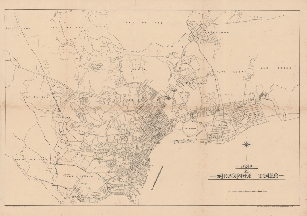
Map of Singapore Town.
1930 (undated) 18 x 23.5 in (45.72 x 59.69 cm) 1 : 39600
1930 (undated) 18 x 23.5 in (45.72 x 59.69 cm) 1 : 39600
Description
This uncommon map of Singapore city was issued c. 1930 by Printers Ltd. The map is based on surveys compiled by the Singapore Improvement Trust. Centered on the Downtown Core, the map covers what is today central Singapore from the Labrador Nature Preserve to Marine Parade, extending inland as far as the MacRitchie Reservoir. Streets, districts, rail lines (both proposed and extent), golf courses, and more are noted. The map notes the Civil Aerodrome, or Kallang Airfield, construction on which began in 1931 and finished in 1937. The presence of the Aerodrome here validates our dating, since only the outline of the space is provided, with none of buildings or other structures noted.
Singapore Improvement Trust
The Singapore Improvement Trust (SIT) is a former government organization responsible for urban planning in Singapore. Formally established in 1927 under the Singapore Improvement Ordinance, it was modeled after similar organizations in India. The SIT was involved in the development of a 'Master Plan', which set out Singapore's developmental direction, from 1952 to 1958. In the late 1950s, plans were set out to replace the SIT with two departments - housing and planning - culminating in two bills that were passed in 1959. With the establishment of the successor organizations by the government of Singapore, the Housing and Development Authority and the Planning Authority, in 1960, the SIT was dissolved.Publication History and Census
This map is based on a map supplied by the Singapore Improvement Trust. It was issued to accompany the Singapore and Malayan Directory. We see other maps from the Singapore and Malayan Directory, a few with the same title, but as this map was issued in multiple editions from 1928 through 1950, and none are dated, it is difficult to pin down a census with greater precision.Cartographer
Printers Limited (fl. c. 1879 - 1940) was a Singapore based printing and publishing company active in the late 19th century and first half of the 20th century. Printers Ltd. provided a range of commercial lithography and printing services ranging from business stationary, to custom account books, to lithography. Among other projects, they issued the Singapore and Malayan Directory. Their offices were at 10 Collyer Quay, and their printing works on Trafalgar Street. More by this mapmaker...
Source
The Singapore and Malayan Directory, (Singapore: Printers Limited) c. 1930.
Condition
Very good. Minor wear on original fold lines. Some archival verso reinforcement.
References
OCLC 55852962.