This item has been sold, but you can get on the Waitlist to be notified if another example becomes available, or purchase a digital scan.
1780 Bellin Map of South America
SouthAmerica-bellin-1780$175.00

Title
Carte de l'Amérique Méridionale.
1780 (undated) 18.25 x 13.5 in (46.355 x 34.29 cm) 1 : 18000000
1780 (undated) 18.25 x 13.5 in (46.355 x 34.29 cm) 1 : 18000000
Description
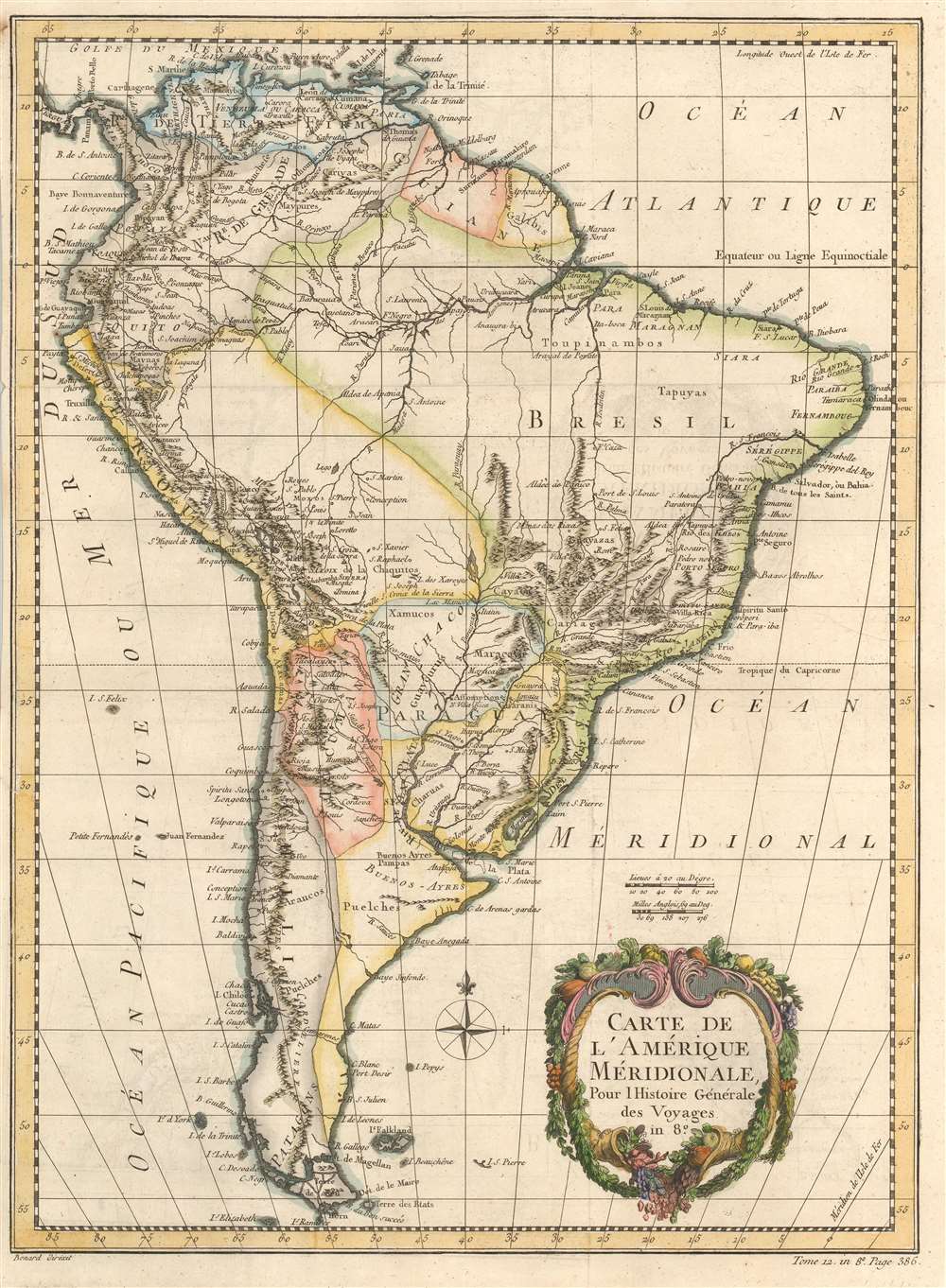
This is a 1780 Jacques-Nicolas Bellin map of South America. Concentrations of detail, particularly along the west coast in Peru, Chile, and throughout northern South America, indicate where most of the era's interest and knowledge was concentrated. Most of Brazil, however, is a blank wasteland occupied by the Amazon rainforest. The Amazon River, on the other hand, and its tributaries, appear in surprising detail. Fort Negro, modern-day Manaus, is labeled near the confluence of the Negro and Solomoes rivers, where it was founded in 1669. Other major cities throughout the continent are identified as well, including Buenos Aires, Montevideo, Cuzco, Cartagena, and Rio de Janeiro. The Rio de la Plata, the Paraguay River, and their tributaries occupy a large portion of south-central South America and include the mythical Laguna de Xarayes.
Laguna de Xarayes
The mythical Laguna de Xarayes is illustrated here as the northern terminus, or source, of the Paraguay River. The Xarayes, a corruption of 'Xaraies' meaning 'Masters of the River', were an indigenous people occupying what are today parts of Brazil's Matte Grosso and the Pantanal. When Spanish and Portuguese explorers first navigated up the Paraguay River, as always in search of El Dorado, they encountered the vast Pantanal flood plain at the height of its annual inundation. Understandably misinterpreting the flood plain as a gigantic inland sea, they named it after the local inhabitants, the Xaraies. The Laguna de los Xarayes almost immediately began to appear on early maps of the region and, at the same time, to take on a legendary quality. Later missionaries and chroniclers, particularly Díaz de Guzman, imagined an island in this lake and curiously identified it as an 'Island of Paradise,'...an island [of the Paraguay River] more than ten leagues [56 km] long, two or three [11-16 km] wide. A very mild land rich in a thousand types of wild fruit, among them grapes, pears and olives: the Indians created plantations throughout, and throughout the year sow and reap with no difference in winter or summer, ... the Indians of that island are of good will and are friends to the Spaniards; Orejón they call them, and they have their ears pierced with wheels of wood ... which occupy the entire hole. They live in round houses, not as a village, but each apart though keep up with each other in much peace and friendship. They called of old this island Land of Paradise for its abundance and wonderful qualities.
Publication History and Census
Originally created for of Abbé Prévost's Histoire Générale des Voyages by Jacques-Nicolas Bellin, this map was published by Jean François de La Harpe's in his Abrégé de l'Histoire Générale des Voyages in 1780. It appears that no examples of this map are cataloged in OCLC, although inconsistencies in cataloging practices mean that may not be the case. The works by Prévost and de la Harpe are well represented institutionally.Cartographer
Jacques-Nicolas Bellin (1703 - March 21, 1772) was one of the most important cartographers of the 18th century. With a career spanning some 50 years, Bellin is best understood as geographe de cabinet and transitional mapmaker spanning the gap between 18th and early-19th century cartographic styles. His long career as Hydrographer and Ingénieur Hydrographe at the French Dépôt des cartes et plans de la Marine resulted in hundreds of high quality nautical charts of practically everywhere in the world. A true child of the Enlightenment Era, Bellin's work focuses on function and accuracy tending in the process to be less decorative than the earlier 17th and 18th century cartographic work. Unlike many of his contemporaries, Bellin was always careful to cite his references and his scholarly corpus consists of over 1400 articles on geography prepared for Diderot's Encyclopedie. Bellin, despite his extraordinary success, may not have enjoyed his work, which is described as "long, unpleasant, and hard." In addition to numerous maps and charts published during his lifetime, many of Bellin's maps were updated (or not) and published posthumously. He was succeeded as Ingénieur Hydrographe by his student, also a prolific and influential cartographer, Rigobert Bonne. More by this mapmaker...
Source
De la Harpe, Abrégé de l'histoire générale des voyages. (Paris) 1780.
Condition
Very good. Exhibits light offsetting.
References
No 1780 edition cataloged in OCLC.