1845 Chambers Map of South America
SouthAmerica-chambers-1845$75.00

Title
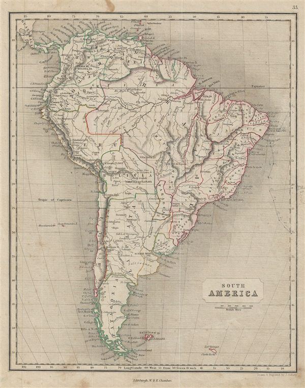
South America.
1845 (undated) 11 x 8.5 in (27.94 x 21.59 cm)
1845 (undated) 11 x 8.5 in (27.94 x 21.59 cm)
Description
This is a fine example of the 1845 Chambers map of South America. It covers the entire continent from the Caribbean Sea to Tierra del Fuego and from the Pacific to the Atlantic Ocean including the Falkland Islands. Depicts the continent in impressive detail – especially the interior, which at the time was largely unknown.
Much of South America was, at this time, embroiled in or about to become embroiled in, severe civil strife. The new nations, freed from Spanish dominance though various wars of liberation in the previous decades, were struggling with their newfound independence in an attempt create stable and prosperous governments. Most dissolved into civil war between 1858 and 1864.
Divided and color coded according to regions and territories, the map identifies various cities, towns, islands, rivers, and an assortment of additional topographical details. This map was drawn and engraved by J. Gellatly.
Cartographer
Chambers (fl. C. 1816 - 1920) was a Scottish bookselling and publishing firm run by brothers William Chambers (April 16, 1800 - May 20, 1883) and Robert Chambers (July 10, 1802 - March 17, 1871). They were born into a prosperous family on the border between Scotland and England. Unfortunately, by puberty their family fortunes had declined due to their father's bad loans to French prisoners of war. Left with little Robert Chambers, then 16, opened a small bookstand on Leith Walk, Edinburgh. His brother William, at 18, opened a bookstand of his own on the same street. A short time afterwards the two joined forces. Due to their thrifty business practices and hard work, the duo quickly developed a thriving business and began publishing. Their first publishing venture was 750 copies of The Songs of Robert Burns, a sure bet in 19th century Edinburgh. They followed up with a series of educational works including several atlases, an encyclopedia, and more Burns books. The firm continued to publish into the early 20th century. More by this mapmaker...
Condition
Very good. Moderate age toning. Blank on verso. Minor stains on margins. Right margin contains erased pencil marks.