This item has been sold, but you can get on the Waitlist to be notified if another example becomes available, or purchase a digital scan.
1850 Tallis Map of South America
SouthAmerica-tallis-1850$80.00

Title
South America.
1850 (undated) 14 x 9.5 in (35.56 x 24.13 cm)
1850 (undated) 14 x 9.5 in (35.56 x 24.13 cm)
Description
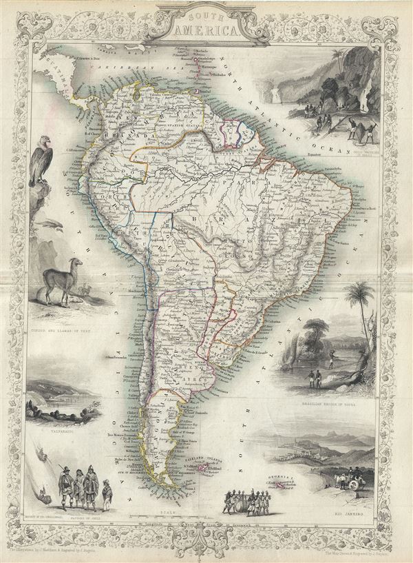
This is John Tallis's extremely attractive c. 1850 Map of South America. Depicts the continent divided into political zones and surrounded by attractive decorative vignettes. Peru is shown divided into North Peru and South Peru. Ecuador, Venezuela, and Columbia are united as Grand Columbia. Modern day Argentina is divided into La Plata, Entre Rios, and Patagonia. Chili extends southward only to the border of Patagonia. Bolivia has a coast. Vignettes include, from the top left in a counterclockwise fashion, a scene from Peru with a Condor and a Lama, a view of harbor of Valparaiso, a sketch of indigenous peoples descending from the Cordilleras, an image of the natives of Chili, an image of indigenous peoples carrying a large barrel, a view of Rio de Janeiro, a drawing of a Brazilian rope bridge, and a view of Gold Washing in Brazil. The whole is surrounded by an attractive decorative border with a floral motif. Prepared by J. Marchant, J. Rogers, and J. Rapkin for issued in John Tallis' 1851 Illustrated Atlas…
Cartographer
John Tallis and Company (1838 - 1851) published views, maps, and atlases in London from roughly 1838 to 1851. Their principal works, expanding upon the earlier maps of John Cary and Aaron Arrowsmith, include an 1838 collection of London Street Views and the 1849 Illustrated Atlas of the World. The firm’s primary engraver was John Rapkin, whose name and decorative vignettes appear on most Tallis maps. Due to the embellishments typical of Rapkin's work, many regard Tallis maps as the last bastion of English decorative cartography in the 19th century. Although most Tallis maps were originally issued uncolored, it was not uncommon for 19th century libraries to commission colorists to "complete" the atlas. The London Printing and Publishing Company of London and New York bought the rights for many Tallis maps in 1850 and continued issuing his Illustrated Atlas of the World until the mid-1850s. Specific Tallis maps later appeared in innumerable mid to late-19th century publications as illustrations and appendices. More by this mapmaker...
Source
The Illustrated Atlas, And Modern History Of The World Geographical, Political, Commercial & Statistical, Edited By R. Montgomery Martin, Esq. …, (1851 edition)
Condition
Very good. Some wear and toning along original centerfold. Blank on verso.
References
Rumsey, 0466.066. Phillips (Atlases) 804-66.