This item has been sold, but you can get on the Waitlist to be notified if another example becomes available, or purchase a digital scan.
1700 Wells Map of South America
SouthAmerica-wells-1700$325.00

Title
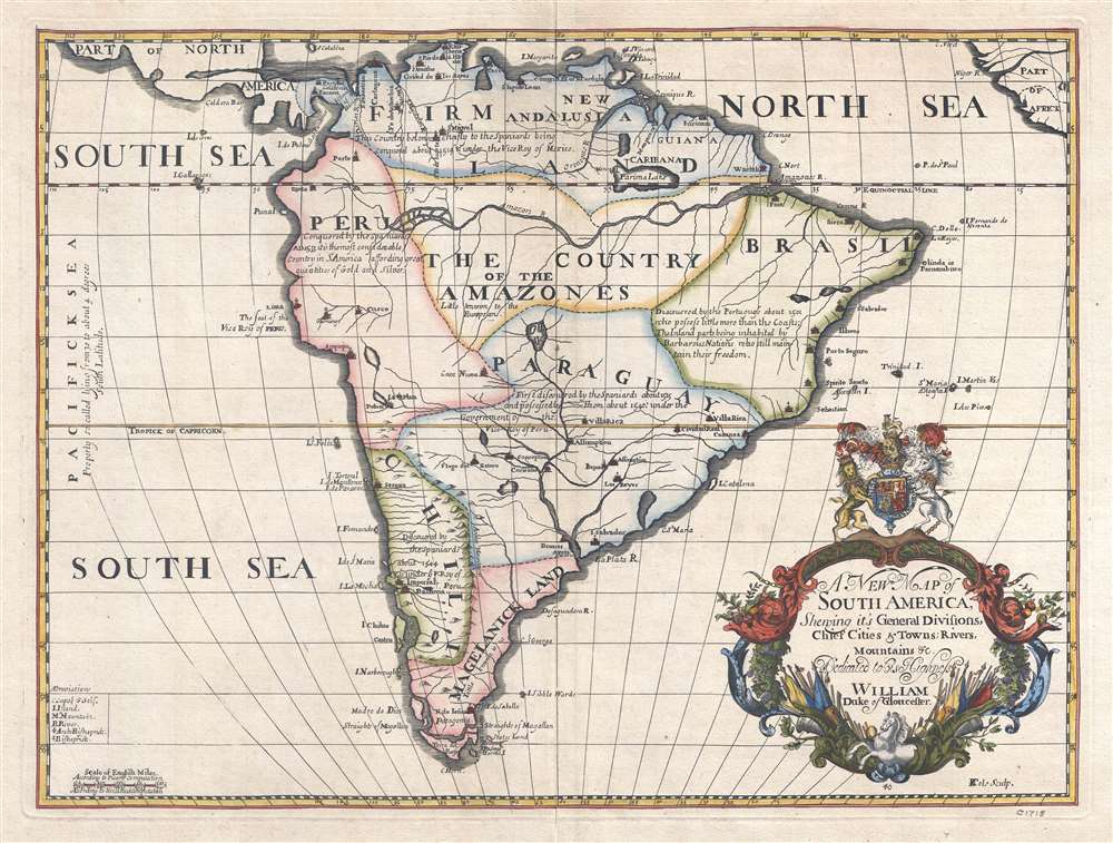
A New Map of South America, Shewing its General Divisions, Chief Cities and Towns; Rivers, Mountains, etc. Dedicated to his Highness William Duke of Gloucester.
1700 (undated) 15.25 x 20.5 in (38.735 x 52.07 cm) 1 : 25000000
1700 (undated) 15.25 x 20.5 in (38.735 x 52.07 cm) 1 : 25000000
Description
This is a 1700 Edward Wells map of South America. Sparsely illustrated, the scarcity of notations reflects the general lack of knowledge concerning the interior of South America. Annotations in each of the regions provide a date for when Europeans (almost entirely Spaniards, except for the Portuguese in Brazil) conquered different regions and installed their own governments. Two regions, 'The Country of the Amazones' and 'Magelanick Land' are 'little known' to Europeans, meaning that they remained unconquered. Even today, the Amazon Rainforest remains one of the least well-known regions on the planet. The Amazon River cuts its way across the northern portion of the continent. Numerous cities are labeled, including Buenos Aires (Buenos Ayres), Assumption, Cusco, Lima, Quito, and Cartagena. Several cities along the Brazilian coast, such as Pernambuco, San Salvador, Porto Seguro, and Spirito Sancto, are names used in modern Brazil either as city names or as names of region. Two lakes, Lake Parima and the Laguna de Xarayes, are both illustrated here, though only Lake Parima is labeled. Both lakes, which hold equal parts reality and fantasy in their mapping, are central to the European conception of South America and play a critical role in the mapping of the continent.
Lake Parima
Most Europeans believed that the likely site of the El Dorado of legend was the mythical city of Manoa, located here on the shores of Lake Parima, near modern day Guyana, Venezuela, or northern Brazil. Manoa was first identified by Sr. Walter Raleigh in 1595. Raleigh did not visit the city of Manoa (which he believed was El Dorado) himself due to the onset of the rainy season, however he described the city, based on indigenous accounts, as resting on a salt lake over 200 leagues wide. This lake, though no longer mapped as such, does have some basis in fact. Parts of the Amazon were, at the time, dominated by a large and powerful Indigenous trading nation known as the Manoa. The Manoa traded the length and breadth of the Amazon. The onset of the rainy season inundated the great savannahs of the Rupununi, Takutu, and Rio Branco or Parima Rivers. This inundation briefly connected the Amazon and Orinoco river systems, opening an annual and well used trade route for the Manoans. The Manoans who traded with the Incans in the western Amazon, had access to gold mines on the western slopes of the Andes, and so, when Raleigh saw gold rich Indian traders arriving in Guyana, he made the natural assumption for a gold hungry European in search of El Dorado. When he asked the Orinocans where the traders were from, they could only answer, 'Manoa.' Thus did Lake Parime or Parima and the city of Manoa begin to appear on maps in the early 17th century. The city of Manoa and Lake Parima would continue to be mapped in this area until about 1800.The Laguna de Xarayes
The mythical Laguna de Xarayes is illustrated here as the northern terminus, or source, of the Paraguay River. The Xarayes, a corruption of 'Xaraies' meaning 'Masters of the River', were an indigenous people occupying what are today parts of Brazil's Matte Grosso and the Pantanal. When Spanish and Portuguese explorers first navigated up the Paraguay River, as always in search of El Dorado, they encountered the vast Pantanal flood plain at the height of its annual inundation. Understandably misinterpreting the flood plain as a gigantic inland sea, they named it after the local inhabitants, the Xaraies. The Laguna de los Xarayes almost immediately began to appear on early maps of the region and, at the same time, to take on a legendary quality. Later missionaries and chroniclers, particularly Díaz de Guzman, imagined an island in this lake and curiously identified it as an 'Island of Paradise,'...an island [of the Paraguay River] more than ten leagues [56 km] long, two or three [11-16 km] wide. A very mild land rich in a thousand types of wild fruit, among them grapes, pears and olives: the Indians created plantations throughout, and throughout the year sow and reap with no difference in winter or summer, ... the Indians of that island are of good will and are friends to the Spaniards; Orejón they call them, and they have their ears pierced with wheels of wood ... which occupy the entire hole. They live in round houses, not as a village, but each apart though keep up with each other in much peace and friendship. They called of old this island Land of Paradise for its abundance and wonderful qualities.
Publication History and Census
This map was created and drawn by Edward Wells and engraved by Benjamin Cole in 1700. We note a single example cataloged in OCLC and it is part of the collection at the University of California Berkeley.CartographerS
Edward Wells (1667 - 1727) was an English mathematician, geographer, and classical scholar based at Christ Church College, Oxford. Wells trained for the ministry but quickly found himself unsuited to religious life and instead applied for an academic position at Oxford, where he authored numerous well respected works on a wide range of mathematical and scientific topics. He tutored Prince William, the sickly son of Queen Anne, who was likely about 11 at the time this map was prepared. Wells dedicated nearly all of the maps in his atlas, A New Sett of Maps both of Ancient and Present Geography, to the young prince - quite possibly posthumously, as William died in July of 1700 shortly prior to the publication of the atlas. Nonetheless, Wells' geography proved popular and was published in number editions well into the 1730s. More by this mapmaker...
Benjamin Cole (1697 - June 15, 1783) was an English engraver and printer. Cole was known for his engravings of architectural subjects and trade cards, among many other subjects. He was an active Freemason and served as the Official Engraver of the Grand Lodge from 1745 - 1767. Learn More...
Condition
Very good. Even overall toning. Verso repairs to centerfold separations. Closed margin tears professionally repaired on verso.
References
OCLC 21803053.