This item has been sold, but you can get on the Waitlist to be notified if another example becomes available, or purchase a digital scan.
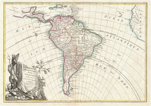
1762 Janvier Map of South America
SouthAmerica2-janvier-1762$100.00

Title
L'Amerique Meridionale divisee en ses principaux Etats.
1762 (dated) 12.5 x 16 in (31.75 x 40.64 cm) 1 : 31000000
1762 (dated) 12.5 x 16 in (31.75 x 40.64 cm) 1 : 31000000
Description
A beautiful example of Jan Janvier's 1762 decorative map of South America. Covers from the island of Hispaniola and the Yucatan south to Tierra del Fuego and Cape Horn, east to Africa, and west to Mexico. Details the whole of the South American continent showing mountains, rivers, national boundaries, cities, regions, and tribes. Identifies the mythical Laguna de Xarayes, supposed gateway to paradise or el Dorado, as the northern terminus of the Paraguay River. Also erroneously links the Amazon and Orinoco Rivers. As this map was drawn most of South America was dominated by the vast and increasingly mismanaged Spanish empire. Only Portuguese Brazil and Spanish and Dutch enclaves in Guyana, disrupted the Spain's continental hegemony. All three empires were aggressively exploiting the continent, with the mountainous western regions being rapaciously mined to supply China and europe's desperate need for silver to stabilize their economies, and the coastal lowlands dominated by sprawling sugar plantations intended to satisfy europe's increasingly insatiable sweet tooth. Meanwhile, much of the interior, in particular the Amazon and Orinoco basins remained largely unexplored. A large decorative title cartouche appears in the lower left quadrant. Drawn by J. Janvier c. 1762 for issue as plate no. 33 in Jean Lattre's 1783 final issue of the Atlas Moderne.
CartographerS
Jean Denis Janvier (fl. 1746 - 1776), sometime also known as 'Robert', was a Paris based cartographer active in the mid to late 18th century. Janvier signed his maps Signor Janvier. By the late 18th century, Janvier was awarded the title of 'Geographe Avec Privilege du Roi' and this designation appears on many of his later maps. Janvier worked with many of the most prominent French, English and Italian map publishers of his day, including Longchamps, Faden, Lattre, Bonne, Santini, Zannoni, Delamarche, and Desnos. More by this mapmaker...
Jean Lattré (170x - 178x) was a Paris based bookseller, engraver, globe maker, calligrapher, and map publisher active in the mid to late 18th century. Lattré published a large corpus of maps, globes, and atlases in conjunction with a number of other important French cartographic figures, including Janvier, Zannoni, Bonne and Delamarche. He is also known to have worked with other European cartographers such as William Faden of London and the Italian cartographer Santini. Map piracy and copyright violations were common in 18th century France. Paris court records indicate that Lattré brought charges against several other period map publishers, including fellow Frenchman Desnos and the Italian map engraver Zannoni, both of whom he accused of copying his work. Lattré likes trained his wife Madame Lattré (né Vérard), as an engraver, as a late 18th century trade card promotes the world of 'Lattré et son Epouse.' Lattré's offices and bookshop were located at 20 rue St. Jaques, Paris, France. Later in life he relocated to Bordeaux. Learn More...
Source
Lattre, Jean, Atlas Moderne ou Collection de Cartes sur Toutes les Parties du Globe Terrestre, c. 1783.
Condition
Very good condition. Original centerfold. Blank on verso. Platemark visible. Minor foxing.
References
Rumsey 2612.075. Phillips (Atlases) 664. National Maritime Museum, 215.