This item has been sold, but you can get on the Waitlist to be notified if another example becomes available, or purchase a digital scan.
1851 Tallis and Rapkin Map of South Australia, Australia
SouthAustralia2-tallis-1851$175.00

Title
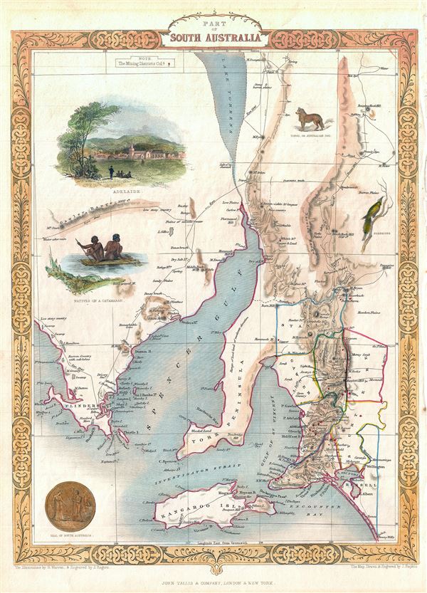
Part of South Australia.
1851 (undated) 14 x 10.5 in (35.56 x 26.67 cm) 1 : 2500000
1851 (undated) 14 x 10.5 in (35.56 x 26.67 cm) 1 : 2500000
Description
This is a beautiful example of John Tallis and John Rapkin's 1851 map of South Australia, Australia. Centered on the Spencer Gulf, it covers the southeastern part of the state of South Australia from Lake Torrens to Kangaroo Island and Bonny Wells. This map depicts the area during the early years of settlement in the only state to be settled by free settlers. The map includes beautiful illustration by H. Warren depicting Adelaide, natives of Catamaran, a Nymphicus, and an Australian dog. The seal of South Australia is also illustrated. Mining districts are depicted with red dots throughout. The map also notes the routes of the English explorer Edward John Eyre in 1840. The whole has the highly decorative presentation and elaborate border distinctive of Tallis maps. This map was issued as part of the 1851 edition of John Tallis and Company's The Illustrated Atlas, And Modern History of the World.
Cartographer
John Tallis and Company (1838 - 1851) published views, maps, and atlases in London from roughly 1838 to 1851. Their principal works, expanding upon the earlier maps of John Cary and Aaron Arrowsmith, include an 1838 collection of London Street Views and the 1849 Illustrated Atlas of the World. The firm’s primary engraver was John Rapkin, whose name and decorative vignettes appear on most Tallis maps. Due to the embellishments typical of Rapkin's work, many regard Tallis maps as the last bastion of English decorative cartography in the 19th century. Although most Tallis maps were originally issued uncolored, it was not uncommon for 19th century libraries to commission colorists to "complete" the atlas. The London Printing and Publishing Company of London and New York bought the rights for many Tallis maps in 1850 and continued issuing his Illustrated Atlas of the World until the mid-1850s. Specific Tallis maps later appeared in innumerable mid to late-19th century publications as illustrations and appendices. More by this mapmaker...
Source
Tallis, J. and F., The Illustrated Atlas, And Modern History Of The World Geographical, Political, Commercial & Statistical, 1851.
Condition
Very good. Blank on verso.
References
Rumsey 0466.054. Phillips (Atlases) 804.