1859 Cole View of South Boston, Massachusetts
SouthBoston-cole-1859-2$4,000.00


Title
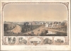
South Boston, 1859. To the Citizens of South Boston - this picture is most respectfully dedicated by the Artist.
1859 (dated) 21 x 30 in (53.34 x 76.2 cm)
1859 (dated) 21 x 30 in (53.34 x 76.2 cm)
Description
A rare view of South Boston in 1859, drawn by Joseph Foxcroft Cole. It depicts the neighborhood of Dorchester Heights at a time when South Boston was growing rapidly, both demographically and territorially.
A Closer Look
The view depicts the Dorchester Heights area of South Boston, oriented towards the northwest, with Boston proper in the background. The intersection of G Street at Thomas Park can be seen in the foreground, with the park and part of the South Boston Reservoir on Telegraph Hill on the left of the view. Fourth Street can be seen in the middle ground, with Boston Harbor, later partially filled in by land reclamation, in the background. Throughout, the view offers scenes from life in Boston during the mid-19th century, with carriages, people on horseback, and pedestrians walking along paths. Along the bottom, five vignettes include the residence of Fredrick Nickerson, Broadway on the corner of G Street, a nautical scene including Fort Independence, the residence of Dr. Samuel Gridley Howe (a prominent abolitionist who served as a commissioner on the American Freedmen's Inquiry Commission), and the residence of Samuel R. Spinney.The South Boston Reservoir and Telegraph Hill
Built in 1849, the South Boston Reservoir was used for water supply to the local area until 1872. It was demolished in 1899 and replaced by the South Boston High School in 1901. Thomas Park, which offered magnificent views of the city, was built in 1852 following the leveling of Telegraph Hill. At the turn of the 20th century, a monument was constructed (just west of the high school) to commemorate the importance of Dorchester Heights to the Siege of Boston during the American Revolutionary War (1775 - 1783).The Development of South Boston
Initially an isthmus called Dorchester Neck across the harbor from Boston, South Boston grew significantly during the 19th century through landfill, urbanization, and industrialization. Large numbers of immigrants, especially from Ireland, settled in the area, which today is still associated with Irish-American culture, along with neighboring Dorchester. The area closest to Boston Harbor in the middle and background here saw some of the first iron works in Boston and, though obscured here by the orientation of the view and elevation, caused the skyline to be dominated by brick and smokestacks.Publication History and Census
This view was drawn and published by Joseph Foxcroft Cole in 1859, an unusual work for the artist, who typically depicted pastoral landscapes. The only known examples in institutional collections are held by the American Antiquarian Society and the Boston Athenaeum.Cartographer
Joseph Foxcroft Cole (November 9, 1837 - 1892) was an American landscape artist of the Barbizon style of landscape painting. Born in Jay, Maine, Cole studied art in Boston and apprenticed alongside Winslow Homer at J. G. Bufford's lithography shop. Afterwards, he moved to France to study with Émile Lambinet and Charles Jacque. He spent much of the 1860s and 1870s in France and found greater recognition there than in his home country, exhibiting his art at several prominent venues. He was, however, awarded a medal at the Centennial Exposition of 1876 in Philadelphia and spent the last years of his life back in Massachusetts. More by this mapmaker...
Condition
Good. Full professional restoration. Mounted on linen. Some crackling. Closed tears evident.
References
OCLC 47105161, 1085916325.