1850 Cowperthwait / Mitchell Map of South Carolina
SouthCarolina-mitchell-1850-2$350.00

Title
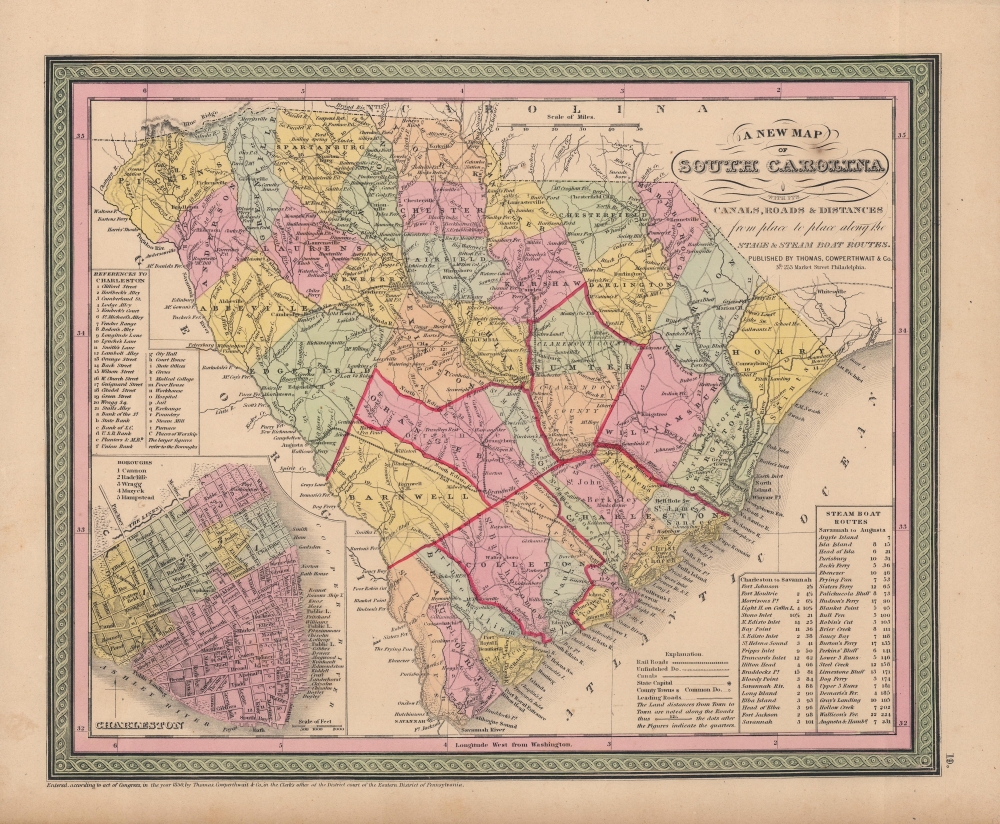
A new map of South Carolina : with its canals, roads and distances from place to place along the stage and steam boat routes.
1850 (dated) 12.5 x 15 in (31.75 x 38.1 cm) 1 : 1400000
1850 (dated) 12.5 x 15 in (31.75 x 38.1 cm) 1 : 1400000
Description
A fine example of Samuel Augustus Mitchell's important 1853 map of South Carolina which appeared in his New Universal Atlas. Among other features, it demonstrates the frenetic pace of railroad construction at the time, tying together different parts of the state and the state with neighboring states.
The rapid addition of new rail lines can be demonstrated by comparing this map with the previous edition of Mitchell's map of South Carolina, published in 1850 (Rumsey 4835.028). By the time of the present map, published in 1853, several new rail lines have sprouted up emanating from Columbia and in the eastern part of the state, leading into North Carolina, causing the legend at bottom to be reconfigures to accommodate lines representing railroads under construction.
A Closer Look
This map shows cities, topographical features, railways, canals, ferries, and roads with color coding at the county level. In addition to cartographic information this map is full of practical data for the traveler, including notes on steamboat and ferry routes. The lower left quadrant bears a detailed inset of Charleston divided into its five boroughs: Cannon, Radcliffe, Wragg, Mazyck, and Hampstead. Important buildings, streets, wharves, and piers are also noted.The rapid addition of new rail lines can be demonstrated by comparing this map with the previous edition of Mitchell's map of South Carolina, published in 1850 (Rumsey 4835.028). By the time of the present map, published in 1853, several new rail lines have sprouted up emanating from Columbia and in the eastern part of the state, leading into North Carolina, causing the legend at bottom to be reconfigures to accommodate lines representing railroads under construction.
Publication History and Census
Cartographically this map is based on the earlier work of Tanner, though it has been updated with new information as well as Mitchell's distinctive decorative border and color scheme. Though Mitchell's name does not appear on the map, it was published as Plate no. 19 in the 1853 edition of Mitchell's New Universal Atlas. Despite being dated and copyrighted in 1850, the present map differs notably from the 1850 edition held by the David Rumsey Map Collection (List No. 4835.028), which resembles the 1849 edition in lacking Cowperthwait's name and the aforementioned new railroad lines. This edition is also recognizable for outlining counties in the southern part of the state in red, highlighting the subdivision of those counties into color-coded parishes, which is lacking in the 1849 and 1850 editions. Eleven institutions in the OCLC independently catalog physical examples of the map with Cowperthwait's imprint (all cataloged as 1850).Cartographer
Samuel Augustus Mitchell (March 20, 1792 - December 20, 1868) began his map publishing career in the early 1830s. Mitchell was born in Bristol, Connecticut. He relocated to Philadelphia in 1821. Having worked as a school teacher and a geographical writer, Mitchell was frustrated with the low quality and inaccuracy of school texts of the period. His first maps were an attempt to rectify this problem. In the next 20 years Mitchell would become the most prominent American map publisher of the mid-19th century. Mitchell worked with prominent engravers J. H. Young, H. S. Tanner, and H. N. Burroughs before attaining the full copyright on his maps in 1847. In 1849 Mitchell either partnered with or sold his plates to Thomas, Cowperthwait and Company who continued to publish the Mitchell's Universal Atlas. By about 1856 most of the Mitchell plates and copyrights were acquired by Charles Desilver who continued to publish the maps, many with modified borders and color schemes, until Mitchell's son, Samuel Augustus Mitchell Junior, entered the picture. In 1859, S.A. Mitchell Jr. purchased most of the plates back from Desilver and introduced his own floral motif border. From 1860 on, he published his own editions of the New General Atlas. The younger Mitchell became as prominent as his father, publishing maps and atlases until 1887, when most of the copyrights were again sold and the Mitchell firm closed its doors for the final time. More by this mapmaker...
Source
Mitchell, S. A., A New Universal Atlas, (Philadelphia: S. A. Mitchell) 1850.
The New Universal Atlas is one of the great American atlases of the mid-19th century. Samuel Augustus Mitchell first issued the atlas in 1846 when he acquired the map plates and copyright for Tanner's New Universal Atlas from its publisher, Carey and Hart. The first transitional 1846 edition was published jointly with Carey and Hart, but a second edition was published in the same year with the Tanner imprint erased. This edition of the atlas also introduced the signature S. A. Mitchell green and pink color scheme. Most of the maps from the early editions of the atlas were engraved by H. N. Burroughs or C. S. Williams, often bearing their copyright. Burroughs maps also tended to have what map collector David Rumsey refers to as the 'Cary and Hart' borders, which featured a narrow vine motif. These borders were replaced, along with the Burroughs imprint, with the more traditional Mitchell strap work border used in the atlases until 1856. Mitchell published editions until late in 1850, when he sold the rights to Thomas, Cowperthwait and Company of Philadelphia. Under Cowperthwait, the atlases continued to be published and bear the Mitchell name until 1856, when the plates were again sold, this time to Charles Desilver. Desilver reworked the plates with new border art and a revised color scheme in the style of J. H. Colton. Desilver issued editions from 1857 to 1860, when the atlas was phased out in favor of Samuel Augustus Mitchell Jr.'s New General Atlas.
Condition
Near excellent. Uneven toning at bottom. Faint soiling in left margin towards bottom.
References
Rumsey 3803.023. OCLC 887221775, 14151577, 39047400.