This item has been sold, but you can get on the Waitlist to be notified if another example becomes available, or purchase a digital scan.
1612 Marc Lescarbot Map of the Southeast Part of North America
Southeast-lescarbot-1612$11,000.00

Title
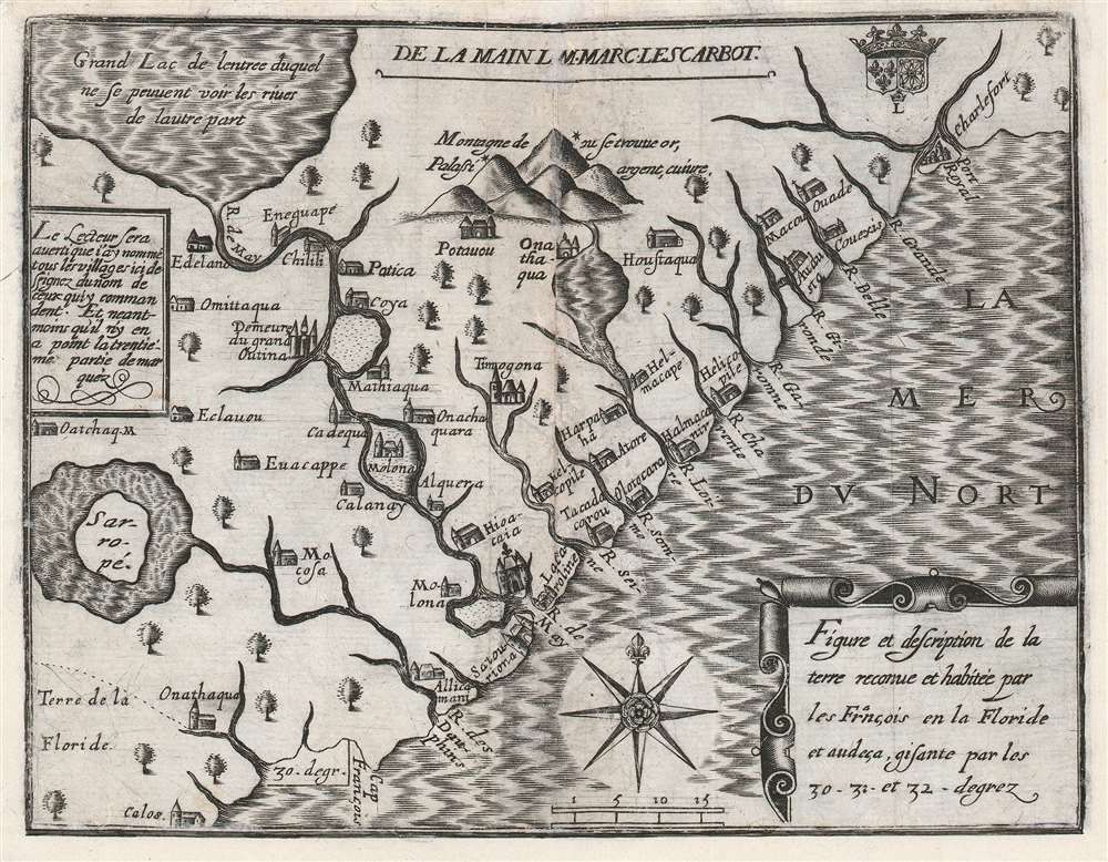
Figure et description de la terre reconue et habitée par les François en la Floride et audeça, gisante par les 30-31 - et 32 - degrez.
1612 (undated) 6.25 x 8.25 in (15.875 x 20.955 cm) 1 : 2661754
1612 (undated) 6.25 x 8.25 in (15.875 x 20.955 cm) 1 : 2661754
Description
One of the great unobtainable maps of early attempts to settle North America. This is Marc Lescarbot's 1612 map of the American Southeast, one of the earliest specific maps detailing modern-day Florida, Georgia, and South Carolina. It chronicles 1562-1565 French attempts to establish a Huguenot colony in the region. Coverage extends roughly from 30° to 33° N, covering parts of modern-day Florida, Georgia, and South Carolina.
All three maps depict a large lake, connected to the River May, and describe it as being so large that one bank cannot be seen from the other - the great apocryphal lake of the American southeast which would appear on maps well into the 18th century. The Le Moyne's depiction of the May gives the river a sharp bend to the southwest - accurately reflecting the course of the St. Johns River to Lake George - with the consequence that the lake appears at more southerly latitude than the mouth of the River. The Lescarbot follows Claesz in running the river to the northwest, and thus moving the lake into Carolina - or even further north. This is likely due to a mis-identification of the River May with another of the great southeaster rivers, possibly the Savannah River, which flows directly from the northwest. Moreover, despite bearing the same name, the course of the river differs sharply between the two latter maps; on Lescarbot's map it meanders less than the Claesz.
A Closer Look
The map strikingly connects a great lake in the northwest, 'from the entrance of which, the shores cannot be seen on the other side' via the river River May to the Atlantic in modern-day Florida or Georgia. A mountain range - 'Palassi' - said to contain gold, silver, and copper can be found near another large inland lake. Native American villages are labeled with the names of their chiefs - Lescarbot notes this convention and cautions the reader that the map shows less than a thirtieth of the actual settlements. Coastal rivers are illustrated with French names - making it difficult in some cases identify the exact river referenced. The Huguenot settlements at Charlefort (Port Royal) and La Caroline (near St. Augustine) are labeled. The R. des Dauphins is connected to the lake/Island Sarropé.A French Colony in Florida
This map was included in Lescarbot's Histoire de la Nouvelle France, a description of the disastrous French effort to establish a colony in the Southeast. At the behest of the Huguenot Admiral Gaspard de Coligny (1519 - 1572), navigator Jean Ribaut (1520 - 1565) set out to establish the colony in 1562. He landed near the mouth of the St. John River, which he named 'May' after the month. Ribaut and his crew then sailed north along the coast until they discovered a large bay, naming it Port Royal and establishing Charlefort, after King Charles IX of France. Facing harsh environmental conditions and limited supplies, the colony immediately foundered, the settlers mutinying and attempting a return to France. An second effort to establish a colony, this time under Rene de Laudonniere (1529 - 1574) followed in 1564. The French set up a settlement along the River May (St. Johns River), named La Caroline. The settlement incited the Spanish, who in order to defend their claims to Florida, sent a fleet under Don Pedro Menéndez de Avilés (1519 - 1574) to remove the 'Heretic French.' This he did, slaughtering the colonists wholesale in 1565, in the process founding St. Augustine. A handful of Huguenot survivors fled, including the artist Jacques Le Moyne (c. 1533 - 1588), who returned to Europe to tell the tale, published by De Bry with a famous map in 1591.Tracing the Source Map
Despite having many features in common, Lescarbot's map is no derivative of the 1591 De Bry / Le Moyne. Rather, it is based on an inset included on the unacquirable 1602 Cornelis Claesz wall map of America. The Lescarbot map shares with the Claesz a more correct positioning of the River May (St. John's River). While all three maps include 'Sarropé', the Le Moyne places it far to the south - about 26° N latitude. Neither Le Moyne nor Claesz connected that lake to any river. Lescarbot's connection of this lake to the R. des Dauphins (roughly St. Augustine) is unique among these early maps.All three maps depict a large lake, connected to the River May, and describe it as being so large that one bank cannot be seen from the other - the great apocryphal lake of the American southeast which would appear on maps well into the 18th century. The Le Moyne's depiction of the May gives the river a sharp bend to the southwest - accurately reflecting the course of the St. Johns River to Lake George - with the consequence that the lake appears at more southerly latitude than the mouth of the River. The Lescarbot follows Claesz in running the river to the northwest, and thus moving the lake into Carolina - or even further north. This is likely due to a mis-identification of the River May with another of the great southeaster rivers, possibly the Savannah River, which flows directly from the northwest. Moreover, despite bearing the same name, the course of the river differs sharply between the two latter maps; on Lescarbot's map it meanders less than the Claesz.
Other Comparisons to the Claesz
The Claesz inset's coastline shows more complicated waterways than the Lescarbot, but the place names of the major rivers are the same: R. des Dauphins, R. de May, R. de Seine, R. de Somme; R. de Loire; the two maps transpose the R. de Garonne and the R. de Charente. The R. de Gironde, R. de Belle, R. de Grande and R. de Charlefort are all roughly follow the Claesz. The colony at Port Royal is shown on both, but Fort Caroline does not appear on the Claesz, having been destroyed. It is included on this map, based on Le Moyne, as a historical reference.Publication History and Census
This map was engraved for inclusion in the 1612 Millot edition of Lescarbot's Histoire de la Nouvelle France and appeared without change in the subsequent 1618 Adrian Perier edition of the work. While we have been unable to scrutinize a confirmed example of the 1612, the earlier edition is sufficiently non-extant that a cautious dating of the present example as 1618 is prudent. We see only four examples of the separate map in institutional collections: two at the Newberry, and one in the British Library. All three are associated with the 1618 edition. On the market, we see neither auction nor dealer listings, this being a unique one-in-a-lifetime discovery.CartographerS
Marc Lescarbot (c. 1570–1641) was a French traveler, author, poet and lawyer. He is best known for his Histoire de la Nouvelle-France (1609), one of the first great books in the history of Canada. His poem Théâtre de Neptune was performed at Port Royal as what the French claim was the first European theatrical production in North America outside of New Spain. He was classically educated, and studied both canonical and civil law. He participated in diplomacy between Spain and France in 1598, and served as a lawyer in Parliament in 1599. During this time he worked as well as a translator, of poetry and medical works, and his time in Paris put him in contact with scholars and printers. He was invited to accompany a de Monts' expedition to Acadia in New France, and he left for America in 1606. He first arrived in Port Royal in July, and stayed the year - making excursions the following spring to the Saint John River and Île Sainte-Croix. He would make some efforts at studying Algonquian numbers, language and songs. It was a short visit: he returned to France in 1607. He had been inspired by his cisit to write a history of the French settlements in America, the first edition of which would be published in Paris in 1609. While most of the work was a compilation of other travelogues, his history of de Monts' venture in Acadia was original work, based both on his own firsthand observations and those of individuals he interviewed. He would continue to edit and improve his accounts in further editions of the work, appearing in 1612 and 1618. His descriptions of First Nations peoples, their customs, remarks, and chants are among the first such detailed depictions of Native Americans. More by this mapmaker...
Jacques Le Moyne de Morgues (c. 1533 - 1588) was a French Huguenot painter born in Dieppe, France in 1533. Little is known of Le Moyne's early life; however, as Dieppe was at the time a center for both painting and cartography, it might be assumed that Le Moyne trained in the city of his birth. It is likely that le Moyne was employed at the court of King Charles IX where he most likely first met the Huguenot Admiral Gaspard de Coligny. Coligny commissioned Le Moyne to accompany his expedition to colonize Florida, where he was to record and map as much of the New World as possible. Under the command of Jean Ribault and Rene Laudonniere from 1562 - 1564, Le Moyne created a series of illustrations and maps depicting indigenous plants, peoples of Florida. This important work, eventually published by Theodore de Bry, is considered to be among first European images of the North American mainland. His important map, Floridae Americase Provinicae is considered to be one of, if not the, most important map of Florida ever published. Nonetheless, contemporary scholars have put Le Moyne's work under intense scrutiny as no original examples of his work remain. Considering the fate of the disastrous Huguenot colony in Florida, it is understandable that little if any of Le Moyne's original work survived and, consequently, it is a safe bet that most of his work was reproduced from memory in London. More likely than not, inconsistencies between Le Moyne's representations of indigenous American peoples, flora and fauna, and actual fact can be attributed to lapses in memory. Following his return returned from the New World, Le Moyne settled in London where he became a prominent botanical illustrator, at times working with such notable personages as Sr. Walter Raleigh. His work expresses typical Calvinist attention to detail and absence of ornamentation. Le Moyne died in London in 1588 having never seen his own work published. It was not until after his death when Le Moyne's widow sold his papers to the Frankfurt publisher Theodore de Bry, that le Moyne's important illustrations of early Florida were finally published. Le Moyne's sole surviving watercolor is held in the collections of the New York Public Library. Learn More...
Source
Lescarbot, M., Histoire de la Nouvelle France, (Paris) 1612 / 1618.
Condition
Good. Centerfold split expertly mended with some loss; margins reinstated with some areas of manuscript restoration of border. Else a bold, sharp strike.
References
OCLC 978252593. Burden, P., The Mapping of North America, 163. Cumming, W., The Southeast in Early Maps, 30.