This item has been sold, but you can get on the Waitlist to be notified if another example becomes available, or purchase a digital scan.
1511 Bernard Sylvanus / Ptolemy Southeast Asia
SoutheastAsia-sylvanus-1511$4,750.00

Title
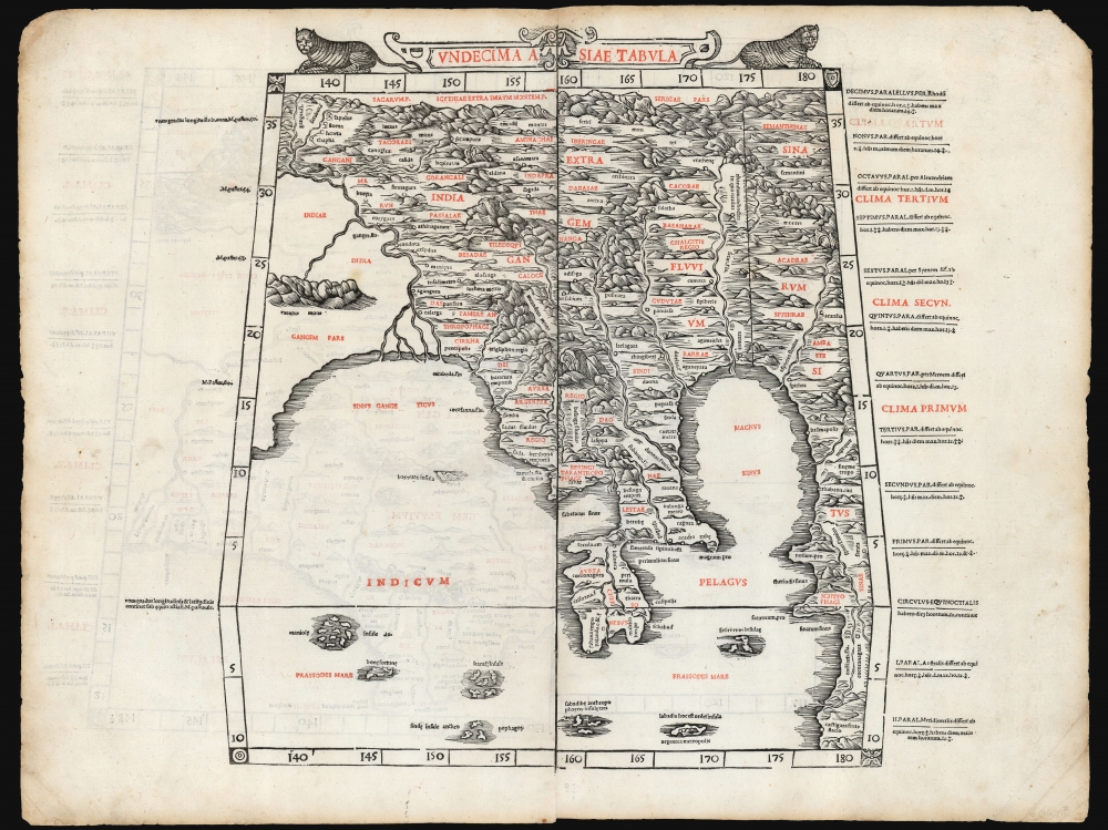
Undecima Asiae Tabula
1511 (undated) 15.75 x 18.25 in (40.005 x 46.355 cm) 1 : 14000000
1511 (undated) 15.75 x 18.25 in (40.005 x 46.355 cm) 1 : 14000000
Description
This is a rare example of Bernard Sylvanus' 1511 Ptolemaic map of Southeast Asia and the Malay Peninsula. Printed in a single edition, it is one of the most visually distinctive early woodcut maps of the Far East, an area known to ancient geographers as 'India Extra Gangem' or 'India Beyond the Ganges'. By Ptolemy's reckoning, this map depicted the easternmost extreme of the Indian Ocean. This part of the world would soon be revealed to contain the East Indies and the Spice Islands.
A Closer Look
The map thus embraces Thailand, Burma, and Vietnam, reaching from the tip of the Malay Peninsula to the Himalayas in the north. The Ganges River is clearly shown and named and forms the western limit of most of the detail. The regions of Aurea Chersonensis (the Malay Peninsula, possibly inclusive of Sumatra) and Aurea regio (Burma, generally) speak to the allure the region held to European armchair explorers (Aurea = Golden). The map portrays two major bodies of water, both with an array of named islands: the Indian Ocean (Indicum Pelagus) and the Sinus Magnus (the Great Bay). To the south, both of these give way to the Prassodes Mare, a sea given its name from the southernmost point of the African east coast in Ptolemy's geography. Beyond the Sinus Magnus to the east is another coastline: This, according to Ptolemy's geography, was contiguous with both China and Africa.Cartographic Context
Ptolemy considered the Indian Ocean to be an inland sea, with the southern part of Africa continuing eastward to meet China beyond the Malay Peninsula. The Sinus Magnus was the body of water enclosed by the Malay Peninsula and the landmass encircling the whole of the Indian Ocean. Contemporaries of Sylvanus knew by this time that such a 'land bridge' between Africa and China did not exist - although some early mapmakers speculated that the eastern shore of the Sinus Magnus might actually have been the newly-discovered American Pacific coastline. The city of Cattigara, appearing in the extreme southeast of the present map, would be found on the South American coastline on the Münster America and the Oronce Fine 1540 world map.An Innovative Production
This map is a woodcut, printed on two sheets. Sylvanus' maps are unique in that they have been systematically printed in two colors, with the topography and some of the place names printed in black and additional toponymy and the cardinal directions printed in red. Although this method did not catch on among other mapmakers, it represents a milestone as one of the earliest maps printed in multiple colors. Moreover, the land masses on Sylvanus' maps display an unusual level of artistry, boldly evoking Ptolemy's imagined mountains and the many rivers snaking through them. While the earlier printed Ptolemies were scantly decorated, Sylvanus' maps were embellished with elegant decorative work. Flanking the map's top-center title cartouche is a pair of well-engraved, glowering tigers.Publication History and Census
This map is among the rarest of its kind. It was cut by Jacopo Pencio (fl. 1486 - 1530, the formschneider's sole known cartographic work) for Sylvanus' Ptolemy, which was printed in a single edition in 1511. We see eight separate examples listed in OCLC. Fourteen examples of the complete book are listed in institutional collections.CartographerS
Bernardus Sylvanus (fl 1465-1511,) or Bernardo Silvani, was an Italian scholar and printer born in the 1460s in Eboli in southern Italy. He is thought to have lived in Naples in 1490, and to have studied Ptolemy there; he produced a manuscript edition of Ptolemy's Geographia there. In 1511 - by this time, in Venice - he published a further edition of Ptolemy's Geographia, the first to be printed in two colors, and the first Italian Ptolemy to be produced using woodblocks. There are no known works by Sylvanus after this one. More by this mapmaker...
Claudius Ptolemy (83 - 161 AD) is considered to be the father of cartography. A native of Alexandria living at the height of the Roman Empire, Ptolemy was renowned as a student of Astronomy and Geography. His work as an astronomer, as published in his Almagest, held considerable influence over western thought until Isaac Newton. His cartographic influence remains to this day. Ptolemy was the first to introduce projection techniques and to publish an atlas, the Geographiae. Ptolemy based his geographical and historical information on the "Geographiae" of Strabo, the cartographic materials assembled by Marinus of Tyre, and contemporary accounts provided by the many traders and navigators passing through Alexandria. Ptolemy's Geographiae was a groundbreaking achievement far in advance of any known pre-existent cartography, not for any accuracy in its data, but in his method. His projection of a conic portion of the globe on a grid, and his meticulous tabulation of the known cities and geographical features of his world, allowed scholars for the first time to produce a mathematical model of the world's surface. In this, Ptolemy's work provided the foundation for all mapmaking to follow. His errors in the estimation of the size of the globe (more than twenty percent too small) resulted in Columbus's fateful expedition to India in 1492.
Ptolemy's text was lost to Western Europe in the middle ages, but survived in the Arab world and was passed along to the Greek world. Although the original text almost certainly did not include maps, the instructions contained in the text of Ptolemy's Geographiae allowed the execution of such maps. When vellum and paper books became available, manuscript examples of Ptolemy began to include maps. The earliest known manuscript Geographias survive from the fourteenth century; of Ptolemies that have come down to us today are based upon the manuscript editions produced in the mid 15th century by Donnus Nicolaus Germanus, who provided the basis for all but one of the printed fifteenth century editions of the work. Learn More...
Source
Ptolemy, C. / Sylvanus, B., Liber geographiae, cum tabulis et universali figura et cum additione locorum quae a recentioribus reperta sunt, diligenti cura emendatus et impressus, (Venice) 1511.
Condition
Excellent. Printed to two sheets from two blocks, joined for binding. Each block exhibiting an even, bold strike. Some marginal wear, else fine for this kind.
References
OCLC 679325025. Nordenskiold, A.E., Facsimile-Atlas, pp. 18-19.