This item has been sold, but you can get on the Waitlist to be notified if another example becomes available, or purchase a digital scan.
1970 U.S. Air Force Aeronautical Chart of Vietnam, Laos, and Cambodia
SoutheastAsia-usaf-1970$600.00

Title
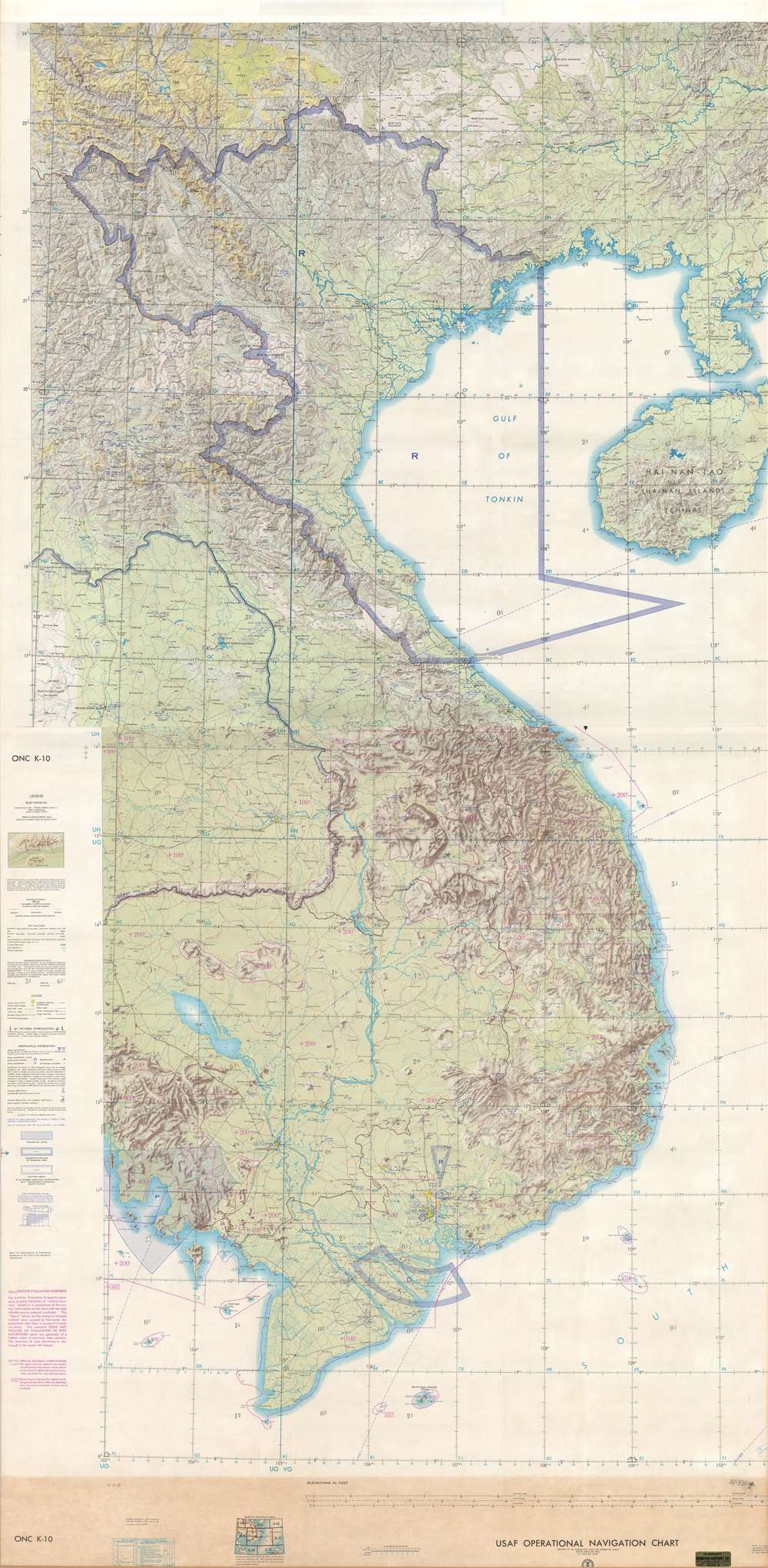
USAF Operations Navigation Chart ONC K-10 / USAF Operations Navigation Chart ONC J-11.
1970 (undated) 77.25 x 38 in (196.215 x 96.52 cm) 1 : 1000000
1970 (undated) 77.25 x 38 in (196.215 x 96.52 cm) 1 : 1000000
Description
This is a c. 1970 United States Air Force aeronautical chart of Southeast Asia. The map, which is two charts joined together and mounted on linen, depicts the region from the meridian 102° east of Greenwich to the Leizhou Peninsula and Hainan and from the 24th parallel north to the Cà Mau Peninsula and the Gulf of Thailand. Highly detailed, myriad cities, towns, and villages are labeled throughout the region, including Saigon, Da Nang, Hué, Hanoi, Haiphong, Dien Bien Phu, Vientiane, and Phnom Penh. Rivers, lakes, and other physical features are also identified. As it is an aeronautical chart, particular attention is given to the elevation and topography of the entire region, with notations in several places on the map stating 'relief data incomplete', signaling to pilots that the terrain in that particular part of the country is unknown. Areas marked thick lines made up of dashed or diagonal blue lines are restricted or prohibited areas, which includes all of North Vietnam.
This map was created by the United States Air Force and published by the Aeronautical Chart and Information Center. Denoyer-Geppert, a Chicago-based publishing firm, joined and mounted the maps for sale. This particular item is a combination of Operational Navigation Chart (ONC) K-10 and J-11, which were originally compiled in 1968 and 1970, respectively.
This map was created by the United States Air Force and published by the Aeronautical Chart and Information Center. Denoyer-Geppert, a Chicago-based publishing firm, joined and mounted the maps for sale. This particular item is a combination of Operational Navigation Chart (ONC) K-10 and J-11, which were originally compiled in 1968 and 1970, respectively.
Cartographer
The Denoyer-Geppert Company (1916 - 1984) was a Chicago-based publishing firm that dealt in maps, atlases, and spherical cartography (globes). For 68 years, the company played a critical role in the education of the world’s students. Founded in 1916 by Otto E. Geppert (the salesman) and L. Philip Denoyer (the cartographer/editor). Denier was born in Milwaukee in 1875 and was a high school principal by the age of 32. He was also completing graduate work at the University of Chicago at the same time. He was appointed the first Professor of Geology and Geography at the State Teacher’s College - La Crosse (University of Wisconsin) in 1909. Legend has it that Denoyer met Geppert while teaching one of his classes, when the latter came up from Chicago to sit in on one. Geppert was working as a salesman for A.J. Nystrom and Company, which today self-identifies as ‘the United States’ older publisher of wall maps and globes for classroom use.’ Geppert was there to sell Denoyer on joining the team at Nostrum, believing that his expertise could benefit the company. Three years later they founded the Denoyer-Geppert Company, and within six years had moved from a 500 square foot space into the 50,000 square foot Swedish-American Telephone Building. By 1922, their catalogue consisted of ‘1,200 maps, charts, globes, and associate aids in teaching geography and history and 800 brilliantly illuminated biological charts and anatomical models.’ In 1967, Denoyer-Geppert was contracted by NASA to build the first official and accurate ‘lunar globe’, based on information gathered by Apollo 10 astronauts. The company made 200 of these globes, the first of which was presented by the astronauts of Apollo 10 to President Nixon. Rand McNally, one of their major competitors, bought out their inventory of maps and globes in 1984. Denoyer-Geppert left the Swedish-American Telephone Building and reinvented the company as the Denoyer-Geppert Science Company, which specializes in anatomical models for classrooms. The Swedish-American Telephone Company has been named a historic landmark and was remodeled into loft apartments. More by this mapmaker...
Condition
Very good. Mounted on linen. Two sheets joined into one map. Light wear along margins. Blank on verso.