This item has been sold, but you can get on the Waitlist to be notified if another example becomes available, or purchase a digital scan.
1952 Pictorial Bird's Eye View Map of Southern California
SouthernCalifornia-roadstoromance-1952$125.00


Title
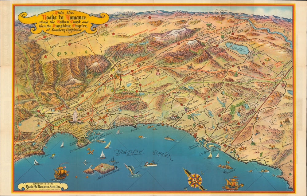
Ride the Roads to Romance along the Golden Coast and thru the Sunshine Empire of Southern California.
1952 (dated) 21.5 x 32 in (54.61 x 81.28 cm)
1952 (dated) 21.5 x 32 in (54.61 x 81.28 cm)
Description
A striking mid-century bird’s eye view of Southern California issued in 1952 by the Roads to Romance Association, Inc. It provides a compact and aesthetically pleasing overview of the region's climate, topography, history, economy, and culture.
One especially curious feature is the Coronado Islands towards bottom-right, noted by a Mexican flag. These islands were the site of an incident during the World War II (1939 - 1945) in which a U.S. Navy ship fired on them for target practice without authorization, mistakenly believing them to be uninhabited and belonging to the U.S. No one was hurt in the incident, but the Mexican government was highly irritated. The commander of the ship, who was relieved of duty as a result, was none other than L. Ron Hubbard, the future founder of Scientology.
A Closer Look
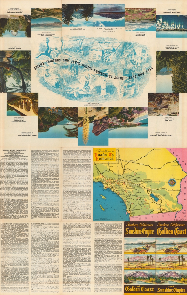
Oriented towards the east, coverage ranges from Malibu to Ensenada in Mexico and includes the counties of Los Angeles, Orange, Riverside, San Diego, Imperial, and San Bernardino. Las Vegas and Death Valley appear on the horizon. Missions, historic trails, major roads and highways, places of interest, historic sites, and natural wonders are represented pictorially throughout. Among these are Malibu Beach, Beverly Hills, Venice, Santa Monica, Laguna Beach, Calico Ghost Town, and the Salton Sea. Fun illustrations of fruits, boats in the ocean, and people engaged in recreational activities are seen throughout, including a female surfer at La Jolla, reflecting the sport's increasing popularity and relative openness. Many of these illustrations refer to idiosyncrasies of Southern California culture at the time, such as the Ramona Pageant in Hemet. Sites labeled with numbers are identified in an extensive index on the verso, which also includes a 'standard' overhead map of the same region, photographs, and illustrations.One especially curious feature is the Coronado Islands towards bottom-right, noted by a Mexican flag. These islands were the site of an incident during the World War II (1939 - 1945) in which a U.S. Navy ship fired on them for target practice without authorization, mistakenly believing them to be uninhabited and belonging to the U.S. No one was hurt in the incident, but the Mexican government was highly irritated. The commander of the ship, who was relieved of duty as a result, was none other than L. Ron Hubbard, the future founder of Scientology.
The Allure of Southern California
Though Southern California has long inspired romanticism among its inhabitants, the region gained new prominence in the postwar period. The population of California more than doubled between 1940 and 1960, led by Southern California (L.A. county's population nearly tripled over the same period), in large part because of the influence of the U.S. military. Conscripts from throughout the country travelled through Southern California during World War II and liked what they saw. After the war, programs to help veterans gain an education and buy a house coincided well with the attractive climate, abundance of land, and a degree of preexisting infrastructure in the region. Southern California is also home to many military bases and an early leader in ancillary industries, such as oil, aviation, and rocketry. Later, the federal government helped facilitate the region's continued growth with the construction of the interstate system.Publication History and Census
This map was produced in 1952 by the Roads to Romance Association, Inc., based in Long Beach. Though not named here, the first edition of the map is generally attributed to Claude Putnam, a local artist who produced a small handful of similar bird's eye views relating to Southern California. There were at least eleven editions of this map issued between 1946 and 1965, frequently with significant changes between them, with this example being the fourth. The present edition is held by eight institutions in the United States.Cartographer
Roads to Romance Association (fl. c. 1945 - 1970) was a California organization founded to promote tourism to southern California in the post-WWII period. It was operational as early as 1945 with financing from hotels, businesses, and county governments to publicize historical and recreational attractions in San Bernardino, San Diego, Riverside, Orange, and Los Angeles Counties. The organization issued several pictorial maps of the region between 1952 and 1959. From 1954, the organization was run by George Savage (1903 - 1961). It operated until at least the 1970s. More by this mapmaker...
Condition
Very good. Minor wear at fold intersections and small marginal tears on fold lines repaired on verso.
References
Rumsey 8009.003. OCLC 25303632, 79947068.