1851 Tallis / Rapkin Map of Southern India
SouthernIndia-tallis-1851$200.00

Title
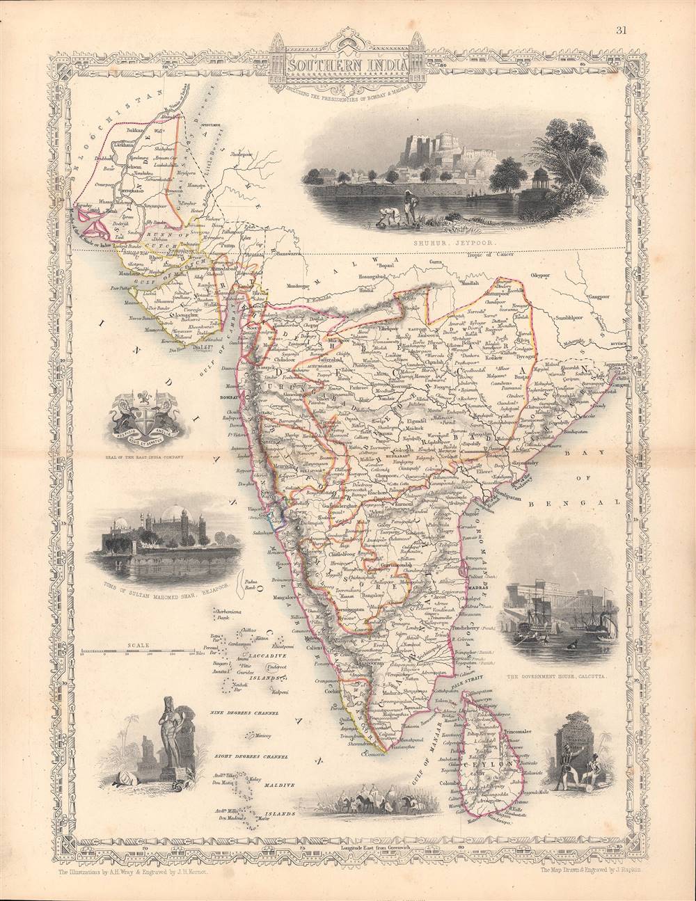
Southern India - including the Presidencies of Bombay and Madras.
1851 (undated) 13.5 x 10.5 in (34.29 x 26.67 cm) 1 : 9000000
1851 (undated) 13.5 x 10.5 in (34.29 x 26.67 cm) 1 : 9000000
Description
This is a rare 1851 map of India drawn and engraved by John Rapkin that appeared in Tallis's Illustrated Atlas and Modern History of the World. The map and illustrations reflect the recent Anglo-Sikh War (1845 - 1846) and show the divisions of the Indian subcontinent soon before the 1857 Mutiny and the inception of the Raj.
By the time this map was made, the EIC effectively controlled the entire Indian subcontinent, usually through intermediaries, local rulers who had aligned themselves with the company. For instance, in the recent Anglo-Sikh War, Gulab Singh, an important Sikh provincial governor, had remained neutral and, once the conflict had ended, paid the EIC 7.5 million rupees plus an annual indemnity and in exchange was made the Maharaja of Jammu and Kashmir. His descendants remained loyal to the British and retained the autonomy of Jammu and Kashmir until the end of the Raj.
Although an autonomous entity, the EIC was increasingly subject to oversight by the British Parliament due to a series of scandals involving corruption and exploitation of the local population. Nevertheless, the company was so profitable and politically powerful that it was difficult to rein in. The conduct and taxes of the EIC irritated Indian landholders, while racial discrimination and a number of social and legal reforms agitated commoners, culminating in the massive rebellion of 1857 - 1858. The uprising began in the ranks of the EIC military itself, among Indian troops known as sepoys, but soon spread to a general social revolt that varied widely by region, religion, and social class. Notably, most of the princely states that had operated with limited autonomy under the EIC remained loyal to it or at least maintained neutrality, including the recently-defeated Sikhs. After the rebellion was suppressed, the EIC was nationalized, and India came under direct rule of the British Crown as the Raj.
Company Rule in India
The map shows the arrangement of princely states and 'presidencies' (areas directly-ruled by the British East India Company) that ruled over the Indian subcontinent prior to the creation of the British Raj. The illustrations mostly show locations in northern India that are not on the map, such as the Government House (now Raj Bhavan) in Calcutta, the Fortress of Shuhur (otherwise known as Amer or Amber Fort) in Jaipur, and the tomb of Muhammad Shah in Delhi. At bottom-right is an illustration without a caption that shows British soldiers writing on a monument: Moodkee, Ferozeshah, Sobraon. These were sites of pivotal battles in the Anglo-Sikh War, with Sobraon being a decisive British victory which ended the war.Background and Aftermath
Until the mid-18th century, the British East India Company (EIC) was similar to the East India Companies of other European powers in that it mostly operated in coastal ports and did not seek to control large portions of territory. That changed when the company expanded its interests in Bengal from a 'factory' (trading post) to gaining the right to collect taxes in Bengal, followed by de facto and eventually de jure rule over Bengal and Bihar. The Battle of Plassey in 1757, an oft-forgotten turning point in world history, gave the British the upper-hand over their competitors in India (particularly the French) and set a precedent of exploiting tensions between local Indian states to expand the power of the EIC.By the time this map was made, the EIC effectively controlled the entire Indian subcontinent, usually through intermediaries, local rulers who had aligned themselves with the company. For instance, in the recent Anglo-Sikh War, Gulab Singh, an important Sikh provincial governor, had remained neutral and, once the conflict had ended, paid the EIC 7.5 million rupees plus an annual indemnity and in exchange was made the Maharaja of Jammu and Kashmir. His descendants remained loyal to the British and retained the autonomy of Jammu and Kashmir until the end of the Raj.
Although an autonomous entity, the EIC was increasingly subject to oversight by the British Parliament due to a series of scandals involving corruption and exploitation of the local population. Nevertheless, the company was so profitable and politically powerful that it was difficult to rein in. The conduct and taxes of the EIC irritated Indian landholders, while racial discrimination and a number of social and legal reforms agitated commoners, culminating in the massive rebellion of 1857 - 1858. The uprising began in the ranks of the EIC military itself, among Indian troops known as sepoys, but soon spread to a general social revolt that varied widely by region, religion, and social class. Notably, most of the princely states that had operated with limited autonomy under the EIC remained loyal to it or at least maintained neutrality, including the recently-defeated Sikhs. After the rebellion was suppressed, the EIC was nationalized, and India came under direct rule of the British Crown as the Raj.
Publication History and Census
This map was part of the well-known Tallis's Illustrated Atlas and Modern History of the World published in 1851. It was drawn and engraved by John Rapkin and the vignette illustrations were drawn by A.H. Wray and engraved by J.H. Kernot. It is held by several libraries in North America, Great Britain, and in former territories of the British Empire (Australia, Singapore).CartographerS
John Rapkin (July 18, 1813 - June 20, 1899) was an English mapmaker and engraver. Born in Southwark, Rapkin was the son of George Rapkin, a shoemaker, and his wife Elizabeth Harfy. Rapkin and his brother Richard both became engravers and his other brother, William Harfy Rapkin, became a copperplate printer. Rapkin produced works for James Wyld and John Tallis, including The United States and the relative position of Oregon and Texas for Wyld around 1845, and a series of eighty maps for Tallis that became 'Tallis's illustrated atlas, and modern history of the world' in 1851. Rapkin married Frances Wilmot Rudell on January 4, 1837, with whom he had at least eight children, some of whom became engravers, including his sons John Benjamin Rapkin (1837 - 1914), Alfred Thomas Rapkin (1841 - 1905), Joseph Clarke Rapkin (1846? - 1912), and Frederick William Rapkin (1859 - 1945). Rapkin operated under the imprint 'John Rapkin and Sons from 1867 until 1883, and was operating as 'John Rapkin and Sons' by 1887. Rapkin died in 1899 at the age of 85 soon after the death of his wife of over sixty years. More by this mapmaker...
John Tallis and Company (1838 - 1851) published views, maps, and atlases in London from roughly 1838 to 1851. Their principal works, expanding upon the earlier maps of John Cary and Aaron Arrowsmith, include an 1838 collection of London Street Views and the 1849 Illustrated Atlas of the World. The firm’s primary engraver was John Rapkin, whose name and decorative vignettes appear on most Tallis maps. Due to the embellishments typical of Rapkin's work, many regard Tallis maps as the last bastion of English decorative cartography in the 19th century. Although most Tallis maps were originally issued uncolored, it was not uncommon for 19th century libraries to commission colorists to "complete" the atlas. The London Printing and Publishing Company of London and New York bought the rights for many Tallis maps in 1850 and continued issuing his Illustrated Atlas of the World until the mid-1850s. Specific Tallis maps later appeared in innumerable mid to late-19th century publications as illustrations and appendices. Learn More...
John Tallis (November 7, 1817 - June 3, 1876) was an English map publisher and bookseller. Born in Stourbridge in Worcestershire, worked in his father's Birmingham agency from 1836 until 1842. Roughly in 1838, Tallis published a collection of London Street Views, and entered into a partnership with his brother Frederick Tallis from 1842 - 1849. Tallis and Company also published the Illustrated Atlas of the World in 1849. Also in 1849, Tallis traveled to New York City where he founded publishing agencies in six American cities. Upon returning from New York, Tallis paid his brother £10,000 for his share of the business, and operated from then on as John Tallis and Company until 1854. By 1853, John Tallis and Company had agencies in twenty-six cities in the United Kingdom, the United States, and Canada and employed over 500 people. By the end of 1853, Tallis had made the decision to share the burden of running such an extensive company and formed the London Printing and Publishing Company on February 24, 1854, becoming co-managing director with Ephraim Tipton Brain. After a series of setbacks, however, Tallis had to sell his estate and by 1861 was declared bankrupt. He was kept afloat by the kindness of friends and former employees, but none of his 'various ambitious projects' ever worked out for the rest of his life. Tallis married Jane Ball on December 6, 1836 in Birmingham, with whom he lived until her death in 1862. Tallis remarried on June 27, 1863 to Mary Stephens, with whom he had two children. Learn More...
James Harfield Kernot (1802 - 1858) was a British engraver whose most prominent work appeared in the various editions of Tallis's Illustrated Atlas and Modern History of the World. He also engraved several series of depictions of landscapes in the British Isles, continental Europe, and the Levant. Learn More...
A.H. Wray (fl. c. 1817 - 1860) was a British illustrator whose most prominent work appeared in the various editions of Tallis's Illustrated Atlas and Modern History of the World. Learn More...
Source
Tallis, J., The Illustrated Atlas, And Modern History Of The World Geographical, Political, Commercial and Statistical, (London and New York: Tallis) 1851.
Condition
Very good. Original fold line visible at center. Slight dampstain in top margin.
References
Rumsey 0466.033. OCLC 46783270.