This item has been sold, but you can get on the Waitlist to be notified if another example becomes available, or purchase a digital scan.
1910 Rand McNally Railroad Map of the Western United States
SouthernUnionPacific-randmcnally-1910$250.00


Title
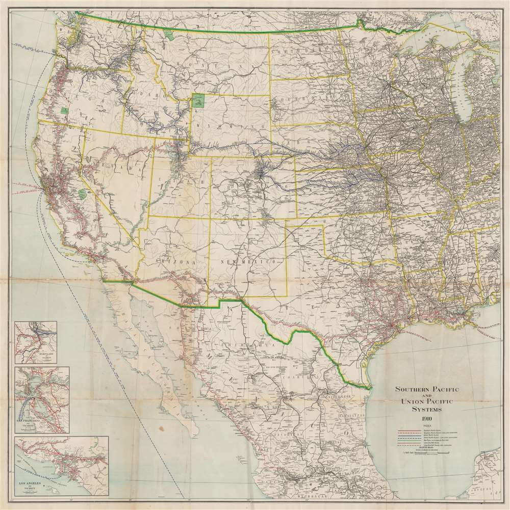
Southern Pacific and Union Pacific Systems.
1910 (dated) 45 x 45 in (114.3 x 114.3 cm) 1 : 3168000
1910 (dated) 45 x 45 in (114.3 x 114.3 cm) 1 : 3168000
Description
This is a 1910 Rand McNally railroad map of the western United States, depicting from Michigan, Kentucky, Tennessee, and Alabama to the Pacific Ocean. Color coding highlights railroads throughout the American West. Union Pacific routes are illustrated in blue, with blue dashed lines representing those under construction. South Pacific routes are colored red. Brown routes are half owned by either the Southern Pacific or Union Pacific and the green routes are operated by the San Pedro, Los Angeles, and Salt Lake Railroad. Black lines trace the rest of the railroad network. National parks appear in green, including Yellowstone, Crater Lake, Glacier, and Yosemite. Insets of Portland, San Francisco, and Los Angeles detailing their railroad networks are situated in the lower-left.
Publication History and Census
This map was created and published by Rand McNally in 1910. We note four examples in OCLC, part of the collection at the Brooklyn Historical Society, Princeton University, Yale University, and Harvard University. We note an additional example at the Huntington Library.Cartographer
Rand, McNally and Co. (fl. 1856 - present) is an American publisher of maps, atlases and globes. The company was founded in 1856 when William H. Rand, a native of Quincy, Massachusetts, opened a print shop in Chicago. Rand hired the recent Irish immigrant Andrew McNally to assist in the shop giving him a wage of 9 USD per week. The duo landed several important contracts, including the Tribune's (later renamed the Chicago Tribune) printing operation. In 1872, Rand McNally produced its first map, a railroad guide, using a new cost effective printing technique known as wax process engraving. As Chicago developed as a railway hub, the Rand firm, now incorporated as Rand McNally, began producing a wide array of railroad maps and guides. Over time, the firm expanded into atlases, globes, educational material, and general literature. By embracing the wax engraving process, Rand McNally was able to dominate the map and atlas market, pushing more traditional American lithographic publishers like Colton, Johnson, and Mitchell out of business. Eventually Rand McNally opened an annex office in New York City headed by Caleb S. Hammond, whose name is today synonymous with maps and atlases, and who later started his own map company, C. S. Hammond & Co. Both firms remain in business. More by this mapmaker...
Condition
Good. Verso repairs to fold separations. Areas of infill and reinforcement along original fold lines.
References
Huntington Library Call Number 492488. OCLC 79112812.