This item has been sold, but you can get on the Waitlist to be notified if another example becomes available, or purchase a digital scan.
1747 Bowen Map of Southern Italy (Naples, Sicily)
SouthItaly2-bowen-1747$175.00

Title
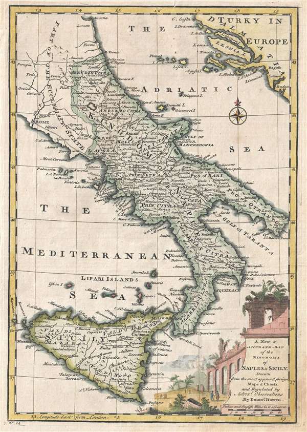
A New and Accurate Map of the Kingdoms of Naples and Sicily.
1747 (undated) 13.5 x 9.5 in (34.29 x 24.13 cm) 1 : 2700000
1747 (undated) 13.5 x 9.5 in (34.29 x 24.13 cm) 1 : 2700000
Description
An attractive 1747 map of southern Italy by the British cartographer Emanuel Bowen. The map covers the Kingdoms of Naples and Sicily, including part of the Papal States, noting important towns, cities, roads, rivers and topography, with mountains rendered pictorially. The title cartouche, appearing in the lower right corner, features a finely engraved illustration of a crumbling Roman aqueduct.
The Crypto-Island of 'M. Sardo'
As authoritative as Magini's 1608 wall map Italia Nuova was, one of its hallmarks - and those maps based on it - was the placement of a mysterious mountainous island 'M. Sardo' in the Gulf of Taranto. Despite being reproduced faithfully on near every 17th century map of the peninsula, the origins of this imaginary island have long been obscure. More recently, the scholar/collector Vladimirio Valerio discovered a interesting notation on the Otranto map in the 1595 Stigliola manuscript Atlas of the Kingdom of Naples (added to his collection in 1975). On that manuscript, a crude mountain-hump is mapped in the Gulf of Taranto - the first known instance in print or otherwise of any such 'M. Sardo' in those waters. While no such island or mountain actually exists, there is, near the tip of Otranto, a mountaintop village - Monte Sardo - notable for its visibility both from the Gulf of Otranto and the Gulf of Venice. Thus the manuscript 'M. Sardo' is a crude coastal profile highlighting a observable coastal navigational feature. Valerio's theorizes that, in compiling his masterpiece map of Italy, Magini consulted the Stigliola as the best and most detailed map of southern Italy. In doing so, he misinterpreted the navigational notation, preserving it as a literal mountain in the middle of the Gulf, and retaining the name M. Sardo. Magini's work was so authoritative that Blaeu copied the map, errors and all; and in turn, with few exceptions, the rest of the European mapmaking community followed.
Publication History and Census
This map was prepared by Emanuel Bowen as plate no. 20 for the 1747 issue of A Complete System of Geography.
Cartographer
Emanuel Bowen (1694 - May 8, 1767) had the high distinction to be named Royal Mapmaker to both to King George II of England and Louis XV of France. Bowen was born in Talley, Carmarthen, Wales, to a distinguished but not noble family. He apprenticed to Charles Price, Merchant Taylor, from 1709. He was admitted to the Merchant Taylors Livery Company on October 3, 1716, but had been active in London from about 1714. A early as 1726 he was noted as one of the leading London engravers. Bowen is highly regarded for producing some of the largest, most detailed, most accurate and most attractive maps of his era. He is known to have worked with most British cartographic figures of the period including Herman Moll and John Owen. Among his multiple apprentices, the most notable were Thomas Kitchin, Thomas Jeffreys, and John Lodge. Another apprentice, John Oakman (1748 - 1793) who had an affair with and eventually married, Bowen's daughter. Other Bowen apprentices include Thomas Buss, John Pryer, Samuel Lyne, his son Thomas Bowen, and William Fowler. Despite achieving peer respect, renown, and royal patronage, Bowen, like many cartographers, died in poverty. Upon Emanuel Bowen's death, his cartographic work was taken over by his son, Thomas Bowen (1733 - 1790) who also died in poverty. More by this mapmaker...
Source
Bowen, E., A complete system of geography. Being a description of all the countries, islands, cities, chief towns, harbours, lakes, and rivers, mountains, mines, etc., of the known world …, (London) 1747.
Condition
Very good. Original platemark visible. Blank on verso. A few minor verso repairs and reinforcements to margins.
References
Rumsey 3733.023. Philips (atlases) 614 (1752 edition).