This item has been sold, but you can get on the Waitlist to be notified if another example becomes available, or purchase a digital scan.
1909 Hyde Map of Long Island (Hamptons), North Fork
Southold-hyde-1909$200.00

Title
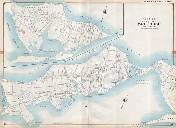
Part of Town of Southold Suffolk Co.
1909 (dated) 27 x 37 in (68.58 x 93.98 cm) 1 : 12000
1909 (dated) 27 x 37 in (68.58 x 93.98 cm) 1 : 12000
Description
This is a 1909 E. Belcher Hyde map of part of the town of Southold located on the North Fork of Long Island in Suffolk County, New York. Often considered a quieter atlernative to the Hamptons in the South Fork, the map depicts the region from Hashamomuck Pond to Terry Point and part of the hamlet of Orient and an inset map situated in the upper left corner continues from Terry Point to Orient Point. The communities of Greenport, East Marion, and Orient are labeled, along with Oyster Ponds, Orient Point, and Brown's Hills, which have since been incorporated into the hamlet of Orient. Properties throughout the region are illustrated and identified using the name of the owner. Kings Highway operates as the main thoroughfare, with numerous smaller streets servicing towns and neighborhoods, particularly in Greenport and Orient. Schools, churches, and stores are highlighted, as is the Long Island Railroad. Coves, harbors, and points are identified all along the coast.
This map was created and published by E. Belcher Hyde in 1909.
This map was created and published by E. Belcher Hyde in 1909.
Cartographer
Hyde and Company (fl. c. 1880 - 1920) (a.k.a. E. Belcher Hyde Map Company) was a Brooklyn, New York, publisher of maps and atlases. Hyde's work primarily focused on Long Island and the fire insurance industry, which required highly detailed maps of cities and towns in order to assess risk and liability. Many of Hyde's maps offered incredible detail at a large scale, including annotations on property owners, building materials, size, and function. While Long Island was the focus of most of the firm's efforts, it also produced atlases of the greater New York City metropolitan area, including the Bronx, Queens, Manhattan, and Westchester. More by this mapmaker...
Condition
Very good. Even overall toning. Backed on linen. Soiling. Shows history of being displayed. Blank on verso.