This item has been sold, but you can get on the Waitlist to be notified if another example becomes available, or purchase a digital scan.
1909 Coffey Soil Map of Southern Texas
SouthTexasSoil-coffey-1909$200.00


Title
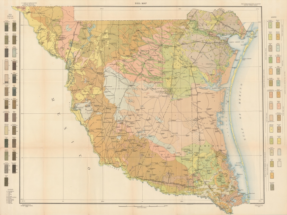
Soil Map. Reconnaissance. Survey South Texas Sheet.
1909 (dated) 28 x 37.25 in (71.12 x 94.615 cm) 1 : 380160
1909 (dated) 28 x 37.25 in (71.12 x 94.615 cm) 1 : 380160
Description
A colorful large-format 1909 map of southern Texas, surveyed by George N. Coffey, a pioneer in American soil science, and published by the Bureau of Soils. It presents the region in an era of consolidation, both of ranches and railways.
A Closer Look
Coverage includes San Patricio, Nueces, Cameron, Hidalgo, Starr, Duval, Zapata, and Webb Counties, and extends to the southernmost portion of Texas, also among the southernmost points in the continental U.S. The map's distinctive coloring reflects a wide variety of sands, loam, and clay, listed in the left and right margins and categorized at right according to color and region. Towns and cities (including Corpus Christi, Laredo, and Brownsville), rivers (including the Rio Grande), ranches, roads, and railways are also displayed in detail. At this time, the region was at the tail end of a railway boom, as smaller ranches were consolidated into huge holdings that were then linked directly to markets via rail. Many of the lines seen here enjoyed only a brief existence as an independent operation in the late 19th century before being merged into larger systems such as the St. Louis, Brownsville and Mexico Railway.Publication History and Census
The surveys for this map were undertaken by George N. Coffey and colleagues, and it was printed by Julius Bien and Co. in New York for the report Reconnaissance Soil Survey of South Texas, authored by Coffey for the Bureau of Soils. The map is independently cataloged among the holdings of Brigham Young University, the University of Chicago, and the U.S. Geological Survey Library, while the entire report is held by thirteen institutions in the United States.CartographerS
George Nelson Coffey (January 17, 1875 - October 4, 1967) was a pioneering American soil scientist (pedologist). Born in North Carolina, he studied geology and chemistry at the University of North Carolina. After graduating, he conducted surveys and wrote reports for the Bureau of Soils. Coffey was instrumental in developing a better soil classification system for the Bureau, though his ideas, influenced by Russian soil scientist Vasily Dokuchaev, were opposed by many within the Bureau (Dokuchaev and Coffey were vindicated in the long run). In 1909, he was named President of the American Society of Agronomy. Coffey is perhaps best known for publishing the first national soil map of the U.S. in the Bureau's bulletin in 1912. However, he had resigned from the Bureau by then and went to work for the Ohio Agricultural Experiment Station (later merged into the Ohio State University). After briefly moving to the University of Illinois, Coffey left academia and government and returned to Ohio to pursue a career in business. More by this mapmaker...
Julius (Julien) Bien (September 27, 1826 - December 21, 1909) was a German-Jewish lithographer and engraver based in New York City. Bien was born in Naumburg, Germany. He was educated at the Academy of Fine Arts, Cassell and at Städel's Institute, Frankfurt-am-Main. Following the suppression of the anti-autocratic German Revolutions of 1848, Bien, who participated in the pan-German movement, found himself out of favor in his home country and joined the mass German immigration to the United States. Bien can be found in New York as early as 1849. He established the New York Lithographing, Engraving & Printing Company in New York that focused on the emergent chromo-lithograph process - a method of printing color using lithographic plates. His work drew the attention of the U.S. Government Printing Office which contracted him to produce countless government maps and surveys, including the Pacific Railroad Surveys, the census, numerous coast surveys, and various maps relating to the American Civil War. Bien also issued several atlases both privately and in conjunction with a relation, Joseph Bien. At the height of his career Bien was elected president of the American Lithographers Association. After his death in 1909, Bien's firm was taken over by his son who promptly ran it into insolvency. The firm was sold to Sheldon Franklin, who, as part of the deal, retained the right to publish under the Julius Bien imprint. In addition to his work as a printer, Bien was active in the New York German Jewish community. He was director of the New York Hebrew Technical Institute, the New York Hebrew Orphan Asylum, and president of the B'nai B'rith Order. Learn More...
Milton Whitney (1860 - November 11, 1927) was a soil surveyor and the inaugural Chief of the Division of Agricultural Soil in the U.S. Department of Agriculture's Weather Bureau, the predecessor to the Bureau of Soils (which has itself evolved into today's National Cooperative Soil Survey). Beginning his career as a Professor of Geology and Soil Physics at the Maryland Agricultural College, Whitney took unconventional stances, proven to be correct with time, that gained him attention in the field and made him a logical choice to lead the USDA's soil bureau when it was established in 1894. He continued to publish research and propose innovative solutions to vexing problems, some of which proved to be inaccurate but led other researchers to test similar theories on soils that were eventually vindicated. Learn More...
Source
Coffey, G., Reconnaissance Soil Survey of South Texas (Washington D.C., Government Printing Office, 1910).
Condition
Very good. Some wear and toning on old fold lines.
References
OCLC 368021156.