1780 Bellin Map of the South-West Coast of Africa, Angola to Cape of Good Hope
SouthWestAfrica-bellin-1780$350.00

Title
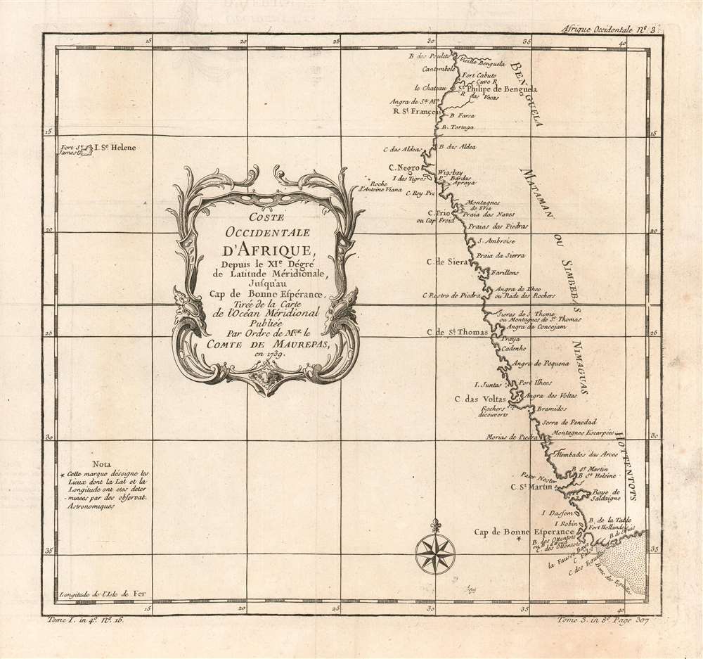
Coste Occidentale D'Afrique, Depuis le XI.e Dégré de Latitude Méridionale, Jusqu'au Cap de Bonne Espérance: Tirée de la Carte de l'Ocean Méridional Publiée Par Ordre de MGR. le Comte De Maurepas en 1739.
1780 (undated) 10 x 8 in (25.4 x 20.32 cm) 1 : 12000000
1780 (undated) 10 x 8 in (25.4 x 20.32 cm) 1 : 12000000
Description
This is a 1780 Bellin map of the southwestern coast of Africa, covering the coasts of Angola, Namibia, and the Atlantic coast of South Africa, as far as the Cape of Good Hope. Table Bay, Cape Agulhas and the Agulhas Banks are named. The map notes the presence of European forts throughout, and also names kingdoms abutting on the coastline: The Kingdom of Benguela, the Kingdom of Mataman, and the NImaguas. The Khoikhoi pastoralists of southern Africa are also noted, using the pejorative Dutch/English terminology name 'Hottentot'. It includes a notation indicating that the Cape's latitude and longitude had been determined by astronomical observation. At the western extreme of the map, the island of St. Helena appears, This was the 'cursed rock' to which Napoleon would be banished in 1815 to serve out his exile, dying there in 1821.
Mapmakers are Recyclers Entirely Worthy of Emulation
Bellin drew the information for this chart from his own superb 1739 chart of the southern Atlantic Ocean, Carte Reduite de l'Ocean-Meridional. It was this grand chart, and not the present lovely if narrowly-focused engraving, that was produced Par Ordre of the Count de Maurepas. It seems slightly misleading that Bellin should here invoke this famous French statesman, naval strategist and spymaster, given that the present map was to appear in Harpe's 1780 Abrégé de l'histoire générale des voyages, which epitomized Prévost's Histoire générale des voyages - a work perhaps better known for its imaginative flourish than for its factuality.Publication History and Census
The map was included in Harpe's 1780 abridged edition of Prévost's Histoire générale des voyages. This map appears on the market from time to time, but OCLC lists only nine copies of the separate map (although inconsistencies in cataloguing mean this number may be higher.) Prévost's Histoire and Harpe's abridged version of it are well represented in institutional collections.Cartographer
Jacques-Nicolas Bellin (1703 - March 21, 1772) was one of the most important cartographers of the 18th century. With a career spanning some 50 years, Bellin is best understood as geographe de cabinet and transitional mapmaker spanning the gap between 18th and early-19th century cartographic styles. His long career as Hydrographer and Ingénieur Hydrographe at the French Dépôt des cartes et plans de la Marine resulted in hundreds of high quality nautical charts of practically everywhere in the world. A true child of the Enlightenment Era, Bellin's work focuses on function and accuracy tending in the process to be less decorative than the earlier 17th and 18th century cartographic work. Unlike many of his contemporaries, Bellin was always careful to cite his references and his scholarly corpus consists of over 1400 articles on geography prepared for Diderot's Encyclopedie. Bellin, despite his extraordinary success, may not have enjoyed his work, which is described as "long, unpleasant, and hard." In addition to numerous maps and charts published during his lifetime, many of Bellin's maps were updated (or not) and published posthumously. He was succeeded as Ingénieur Hydrographe by his student, also a prolific and influential cartographer, Rigobert Bonne. More by this mapmaker...
Source
De la Harpe, Abrégé de l'histoire générale des voyages. (Paris) 1780.
Condition
Very good condition; some slight variations in toning. Else excellent with a bold strike and generous margins.
References
OCLC 163336820. Afriterra 67.