1845 Ewing Map of Spain and Portugal
SpainPortugal-ewing-1845$100.00

Title
Spain and Portugal.
1845 (undated) 8.5 x 9.5 in (21.59 x 24.13 cm) 1 : 5800000
1845 (undated) 8.5 x 9.5 in (21.59 x 24.13 cm) 1 : 5800000
Description
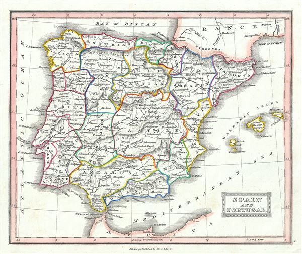
This is a lovely example of Thomas Ewing's 1845 map of Spain and Portugal. It covers all of the Iberian Peninsula from the Pyrenees to the Strait of Gibraltar and includes the Balearic Islands of Ibiza, Majorca, and Minorca. The lower right quadrant features an inset map of Gibraltar. Throughout, the map identifies various cities, towns, rivers, lakes, roadways and an assortment of additional topographical details.
As this map was printed liberal sentiments within Spain were gaining popularity. This eventually led to the Progressive Biennium, in which the Progressive Party tried to replace the conservative liberalism of the Moderate Party with more radical liberalism.
This map was published in 1845 by Oliver and Boyd as part of Ewing's New General Atlas.
Source
Oliver and Boyd, Ewing's New General Atlas: containing Distinct Maps of all the Principal States and Kingdoms throughout the World, (Edinburgh) 1845.
Condition
Very good. Minor foxing at places. Blank on verso.