This item has been sold, but you can get on the Waitlist to be notified if another example becomes available, or purchase a digital scan.
1854 Mitchell Map of New York State
StateNewYork-mitchell-1854$125.00

Title
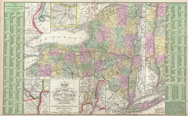
Map of the State of New York Compiled from the Latest Authorities.
1854 (undated) 16.6 x 26.5 in (42.164 x 67.31 cm) 1: 1130000
1854 (undated) 16.6 x 26.5 in (42.164 x 67.31 cm) 1: 1130000
Description
A fine example of Thomas Cowperthwait and S. A. Mitchell's 1854 map of New York State. The fact that this is one of only two double page maps in Mitchell's New Universal Atlas testifies to the importance of New York in the mid-19th century. Covers the entire state from Lake Erie to the Connecticut Vermont border and from Canada to New York City. Steamboat and railway routes throughout the state are noted. Five insets highlight Niagara Falls, Rochester, the vital New York City - Albany corridor, New York City's environs, and the vicinity of Albany. To the left and right of the map proper statistical data from the 1850 Census is arranged in tabular format. Political and topographical features are noted and color coded with elevation rendered by hachure.
This map was prepared by S. A. Mitchell for publication by the Philadelphia firm of Thomas Cowperthwait and Co. in the 1854 edition of Mitchell's New Universal Atlas.
This map was prepared by S. A. Mitchell for publication by the Philadelphia firm of Thomas Cowperthwait and Co. in the 1854 edition of Mitchell's New Universal Atlas.
Cartographer
Samuel Augustus Mitchell (March 20, 1792 - December 20, 1868) began his map publishing career in the early 1830s. Mitchell was born in Bristol, Connecticut. He relocated to Philadelphia in 1821. Having worked as a school teacher and a geographical writer, Mitchell was frustrated with the low quality and inaccuracy of school texts of the period. His first maps were an attempt to rectify this problem. In the next 20 years Mitchell would become the most prominent American map publisher of the mid-19th century. Mitchell worked with prominent engravers J. H. Young, H. S. Tanner, and H. N. Burroughs before attaining the full copyright on his maps in 1847. In 1849 Mitchell either partnered with or sold his plates to Thomas, Cowperthwait and Company who continued to publish the Mitchell's Universal Atlas. By about 1856 most of the Mitchell plates and copyrights were acquired by Charles Desilver who continued to publish the maps, many with modified borders and color schemes, until Mitchell's son, Samuel Augustus Mitchell Junior, entered the picture. In 1859, S.A. Mitchell Jr. purchased most of the plates back from Desilver and introduced his own floral motif border. From 1860 on, he published his own editions of the New General Atlas. The younger Mitchell became as prominent as his father, publishing maps and atlases until 1887, when most of the copyrights were again sold and the Mitchell firm closed its doors for the final time. More by this mapmaker...
Source
Mitchell, S. A., A New Universal Atlas Containing Maps of the various Empires, Kingdoms, States and Republics Of The World, (Thomas Cowperthwait & Co., Philadelphia) 1854.
Condition
Very good. Minor wear and toning along original centerfold. Some spotting at places. Minor verso repair near bottom margins.
References
Rumsey 4328.014 (1855 edition). Phillips (Atlases) 6118.