This item has been sold, but you can get on the Waitlist to be notified if another example becomes available, or purchase a digital scan.
1851 Wyld Map of Transatlantic Mail Steamship Routes
SteamPacketChart-wyld-1851$600.00

Title
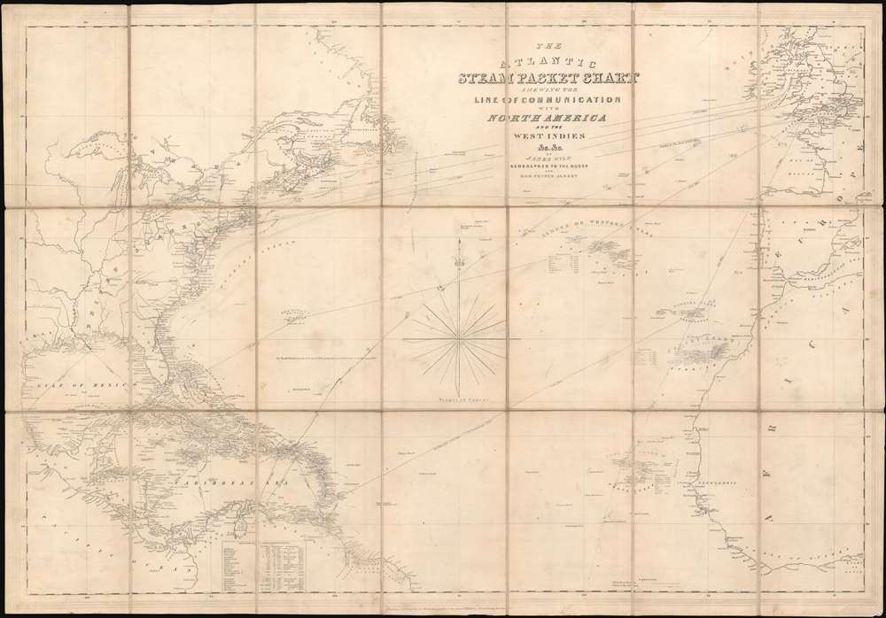
The Atlantic Steam Packet Chart Shewing the Line of Communication with North America and the West Indies etc. etc.
1851 (undated) 23.625 x 34.25 in (60.0075 x 86.995 cm) 1 : 9000000
1851 (undated) 23.625 x 34.25 in (60.0075 x 86.995 cm) 1 : 9000000
Description
This is a c.1851 James Wyld map of transatlantic steam packet (steamships delivering mail) routes. The map depicts the region from Mexico to the North Sea and from Scotland to French Guyana and the Bight of Benin. Several routes are illustrated, with distances marked on each. Some routes are explicitly labeled, such as the London to New York route (3480 miles), while others have only distances between waypoints indicated. Two manuscript routes, one from Portsmouth to the Virgin Islands and another from the Lisbon to the Madeira Islands to the Cape Verde Islands and then further south, are also present. Tables provide census data for the Atlantic archipelagos, including the Azores, Canary Islands, Cape Verde Islands, and the British possessions in the West Indies.
Steam Packets in the mid-19th century
Packet ships, which gained their name from the mail packets transported on government mail contracts, began operating as early as the 17th century. Packet boats carried mail from Britain across the Atlantic to their American colonies, and then to the United States following the American Revolution at least once a month. With the advent of steam powered navigation in the late 1830s and 1840s, transporting mail long distances became much faster and more economical. This technological advancement created an opportunity for a wider swath of the populace to send mail internationally.How Transatlantic Mail Was Handled
Letters that crossed the Atlantic would be sent to the port city and then forwarded from the port city's post office to the ship on the day of departure, typically Saturday in New York City. Since the arrival of steam packets was a major event at the time, their expected arrival and departure dates would be printed in local newspapers. Thus, senders would know which steamers would be arriving on what date and would even write the name of their intended ship on the letter, essentially providing routing instructions to postal workers. Once the mail arrived in its destination port, it would be delivered to the local post office, or, depending on the line carrying the mail, could be picked up dockside at the line's offices.Publication History and Census
This map was created by James Wyld and published c. 1851. We dated this map based on our research of the transatlantic steam packet industry and the presence of entries in the OCLC. The British Library holds examples of a map bearing this title which it has dated to 1842 and 1851, respectively. We believe, based on our research, that the present example dates from 1851. The only example catalogued in the OCLC is the aforementioned at the British Library.Cartographer
Wyld (1823 - 1893) was a British publishing firm active throughout the 19th century. It was operated by James Wyld I (1790 - 1836) and his son James Wyld II (November 20, 1812 - 1887) were the principles of an English mapmaking dynasty active in London during much of the 19th century. The elder Wyld was a map publisher under William Faden (1749 - 1836) and did considerable work on the Ordinance Survey. On Faden's retirement in 1823, Wyld took over Faden's workshop, acquiring many of his plates. Wyld's work can often be distinguished from his son's maps through his imprint, which he signed as 'Successor to Faden'. Following in his father's footsteps, the younger Wyld joined the Royal Geographical Society in 1830 at the tender age of 18. When his father died in 1836, James Wyld II was prepared to fully take over and expand his father's considerable cartographic enterprise. Like his father and Faden, Wyld II held the title of official Geographer to the Crown, in this case, Queen Victoria. In 1852, he moved operations from William Faden's old office at Charing Cross East (1837 - 1852) to a new, larger space at 475 Strand. Wyld II also chose to remove Faden's name from all of his updated map plates. Wyld II continued to update and republish both his father's work and the work of William Faden well into the late 1880s. One of Wyld's most eccentric and notable achievements is his 1851 construction of a globe 19 meters (60 feet) in diameter in the heart of Leicester Square, London. In the 1840s, Wyld also embarked upon a political career, being elected to parliament in 1847 and again in 1857. He died in 1887 following a prolific and distinguished career. After Wyld II's death, the family business was briefly taken over by James John Cooper Wyld (1844 - 1907), his son, who ran it from 1887 to 1893 before selling the business to Edward Stanford. All three Wylds are notable for producing, in addition to their atlas maps, short-run maps expounding upon important historical events - illustrating history as it was happening - among them are maps related to the California Gold Rush, the New South Wales Gold Rush, the Scramble for Africa, the Oregon Question, and more. More by this mapmaker...
Condition
Very good. Dissected and mounted on linen in 21 panels. Light wear along oringial fold lines. Blank on verso.
References
OCLC 556438705.