This item has been sold, but you can get on the Waitlist to be notified if another example becomes available, or purchase a digital scan.
1775 Ottens Map of Saint Eustatius, West Indies
StEustatius-ottens-1775$825.00

Title
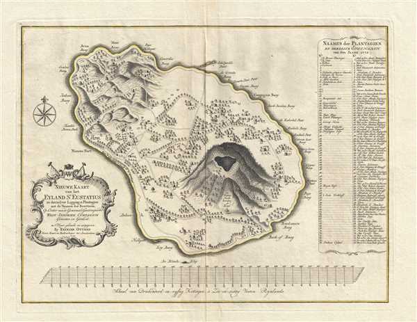
Nieuwe Kaart van het Eyland St. Eustatius in derzelver Ligging en Plantagien met de Naamen der Besitteren, Op Order van de Generaale Geoctroojeerde West-Indische Compagnie.
1775 (dated) 14.75 x 19.5 in (37.465 x 49.53 cm) 1 : 23000
1775 (dated) 14.75 x 19.5 in (37.465 x 49.53 cm) 1 : 23000
Description
This is a rare 1775 Reinier Ottens map of Saint Eustatius, an island in the Caribbean. The map depicts the entirety of the island, from Buccaneer's Bay to Venus Bay and from to Company Bay. Ordered by the Dutch West India Company, 76 different locations (most of which are plantations) are numerically identified by the land owner's name in a table along the right border. Several of these locations are illustrated on the map by small houses. Numerous locations along the coast of the island are labeled, including Key Bay, New Fort, and Jenkins Bay. Prominently featured in the lower portion of the island is the Quill volcano, which today is Quill National Park. An attractive title cartouche is situated along the left border.
Saint Eustatius, a special municipality of the Netherlands, was first seen by Christopher Columbus in 1493. Following the establishment of the first European settlement, between the 17th century and the early 19th century, St. Eustatius changed hands twenty-two times. In 1636, the island became a part of the Dutch West India Company and was reportedly uninhabited. By 1678, St. Eustatius, Sint Maarten, and Saba were all under the control of the Dutch West India Company.
By the 18th century, St. Eustatius sat in the middle of Danish, British, French, and Spanish possessions in the Caribbean. Between their stated neutrality, large harborage, and status as a free port after 1756, St. Eustatius became a major transshipment hub for goods and contraband. Its economy flourished and eventually the island became known as The Golden Rock.
During the American Revolutionary War, a good relationship developed between St. Eustatius and the fledgling United States. Due to its status as a free port, the island sold arms and ammunition to anyone with the ability to pay, which led to its status as one of the few places the rebellious colonies could obtain arms. On November 16, 1776, the American brig Andrew Doria sailed into the bay below Fort Oranje and announced its arrival by firing a thirteen-gun salute. The governor of the island, Johannes de Graaf, replied with an eleven-gun salute, as it was international protocol to reply with two fewer guns. This was the first international recognition of American independence. The Andrew Doria also brought a copy of the Declaration of Independence to be presented to Governor de Graaf.
Because it had officially recognized the rebellious Americans (and supplied them with arms), St. Eustatius was one of the major catalysts in the outbreak of the Fourth Anglo-Dutch War in 1780. A large British force invaded the island in 1781 to little resistance, since no army was maintained there. Ten months later, the French (a Dutch ally) reconquered the island and the Dutch regained control in 1784.
Today, following the dissolution of the Netherlands Antilles in October 2010, St. Eustatius opted to become a special municipality of the Netherlands.
This map was produced and published by Reinier Ottens in 1775. Like many Ottens maps it is a separate issue although it can occasionally be found bound into composite atlases.
Cartographer
Ottens (fl. c. 1680 - 1785) was a prominent Amsterdam map publishing family active for nearly 100 years. Joachim Ottens (1663 - 1719) was born in Amsterdam to a family of seafarers and educated in Amsterdam's Evangelical Lutheran community. He likely learned copperplate engraving under Frederick de Wit (1629 - 1706), for whom he worked until about 1710. In 1710, he was admitted to the Sint-Lucasgilde (Guild of St. Luke) and, in 1711, Joachim founded his own firm. Although Joachim died only a few years later, in 1719, his widow continued the business, either publishing as either 'I. Ottens', 'Ottens', or 'In de Wereldcaert' [In the World Map]. In 1726, Joachim Otten's sons, Renier (1698 - 1750) and Joshua (1698 - 1750), established a partnership and generally published as 'R. and I. Ottens'. Although they ran separate shops, on Nieuwendijk and Kalverstraat, they worked jointly as a singular business until Renier's death in 1750, at which point Joshua assumed full control. After Joshua's death in 1765, his widow continued the firm with their son, Renier II, changing the imprint to 'Joshua and Reinier Ottens.' Joshua's widow, Johanna de Lindt, held an auction sale of their engraved plates in 1784. Ottens' work stands out in that all of their maps were separate issues, though often found compiled into special, made-to-order multi-volume composite Atlas factice works, such as the Atlas. Some examples of the Atlas include over 800 separately issued maps. Because they were not uniformly issued in standard atlases, Ottens maps are often of the utmost rarity and are notable for their exceptionally rich engraving. More by this mapmaker...
Condition
Very good. Margin centerfold separations professionally repaired on verso. Blank on verso.
References
OCLC 71578922.