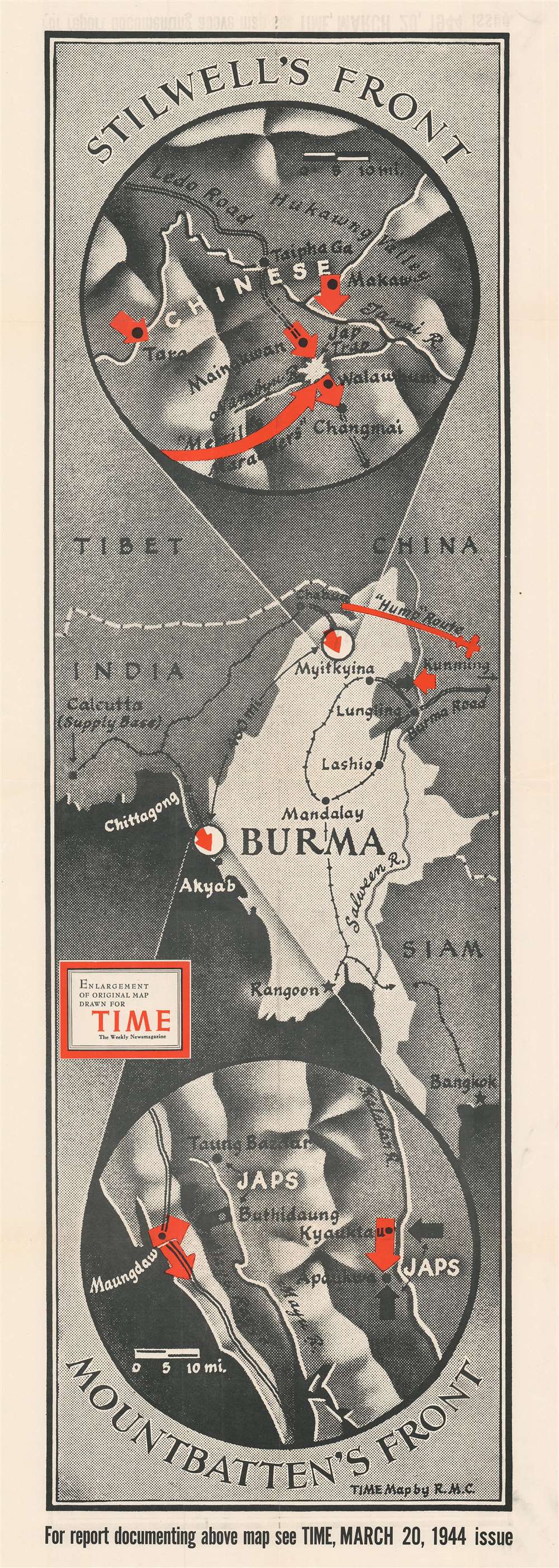
1944 Chapin Map of Burma / Myanmar during World War II
StillwellMountbattenBurma-chapin-1944$400.00

Title
Stilwell's Front. Mountbatten's Front.
1944 (dated) 44.75 x 16 in (113.665 x 40.64 cm)
1944 (dated) 44.75 x 16 in (113.665 x 40.64 cm)
Description
Created during the beginning of the 1944 World War II Allied offensive to liberate Burma from the Japanese, this is a 1944 Robert M. Chapin, Jr. map of Burma. Two circular insets detail both battlefronts, commanded by American General Joseph Stilwell and British Admiral Louis Mountbatten. Red arrows highlight the Allied advance in both sectors. Stilwell's forces (depicted in the top inset) marched through northern Burma and reopened the critical Ledo Road, an overland supply route to Chiang Kai-shek's nationalist Chinese forces. Mountbatten's army (bottom circular inset) attacked Japanese forces farther south along the Indian Ocean.
The China Burma India Theater
The China Burma India Theater (CBI) was a second front for the Western Allies in the Pacific War. Burma, another British colony, was caught between British India and Japanese allied Thailand to the east. The Americans recognized India as a base of operations to resupply Chiang Kai-shek's Chinese nationalists in China. Kai-shek's fight against the Japanese bogged down hundreds of thousands of Japanese troops, making them unavailable to fight against the Americans elsewhere in the Pacific. In Spring 1942, the Japanese launched an offensive aimed at conquering Burma and closing overland supply routes. This campaign proved successful, and the Japanese pushed the Allies out of Burma and back to India.The Burma Campaign of 1944 – 1945
The defeats of 1942, and subsequent losses in 1943, forced the Allies to reevaluate their plan going forward. In August 1943, a commando unit led by Major General Frank Merrill, 'Merrill's Marauders,' infiltrated Burma, where they utilized guerrilla tactics to harass the Japanese behind the lines. In February 1944, the Marauders attacked the Japanese 18th Division, allowing other elements of the American army under General Stilwell to gain a foothold in Burma. Following the Japanese defeats at Imphal and Kohima later in 1944, which stalled the Japanese invasion of India, the Allies began moving south in pursuit of the retreating Japanese. The Allies won victories at Meiktila and Mandalay before advancing on to Rangoon (Yangon), which was liberated in May.Publication History and Census
This map is a separately-issued large-format edition of a map drawn by Robert M. Chapin, Jr. for publication in the March 20, 1944 issue of TIME Magazine. Two examples are cataloged in OCLC and are part of the collections at Franklin and Marshall College and Wichita State University. A collection stamp from the Ashtabula Public Library in Ohio appears on the verso. We have contacted the library and confirmed that it was legally deaccessioned in the 1990s.Cartographer
Robert M. Chapin Jr. (fl. 1933 - 1970) was a prominent architect, cartographer and illustrator active during World War II and the Cold War. Chapin graduated from the University of Pennsylvania in 1933 with a degree in architecture. Since this was the height of the Great Depression, and architects in low demand, he instead took work as a staff cartographer at Newsweek. Catching the attention of Manfred Gottfried of Time, Chapin was offered an accepted a position at the head of Time's cartography department. He remained with Time for some 33 years, from 1937 to 1970, often drawn 2 - 3 new thematic maps weekly. With an architect's gift visualizing information, Chapin became a skilled informational cartographer, heading the cartography department at Time Magazine. Chapin, like Fortune Magazine chief cartographer, Richard Edes Harrison, Chapin was at the forefront of infographic propaganda cartography, a genre that matured during the World War II Era and remains popular today. Working for Time Magazine, Chapin developed a signature style for his long run of 'War Maps.' Chapin was known for his maverick airbrush technique which lead to strong color splashes and intense shading. He also incorporated celluloid stencils to illustrate bomb explosions, flags, sinking ships, and more - generating a instantly recognizable standardized style. Chapin's Time war maps were further distinctive for their use of strong bold reds as a universal symbol of hostility. Chapin graduated from the University of Pennsylvania in 1933 with a degree in architecture. Since this was the height of the Great Depression, an d architects in low demand, he instead took work as a staff cartographer at Newsweek. Catching the attention of Manfred Gottfried of Time, Chapin was offered an accepted a position at the head of Time's cartography department. He remained with Time for some 33 years, from 1937 to 1970, often drawn 2 - 3 new thematic maps weekly. Chapin live in Sharon Connecticut. More by this mapmaker...
Condition
Very good. Light wear along original fold lines. Bears collection stamp from the Ashtabula Public Library in Ohio on verso. We have contacted the library and confirmed that it was legally deaccessioned.
References
OCLC 48037924.