This item has been sold, but you can get on the Waitlist to be notified if another example becomes available, or purchase a digital scan.
1757 Bellin Map of St. Lawrence River, Quebec, Canada
StLawrenceRiver-bellin-1757$100.00

Title
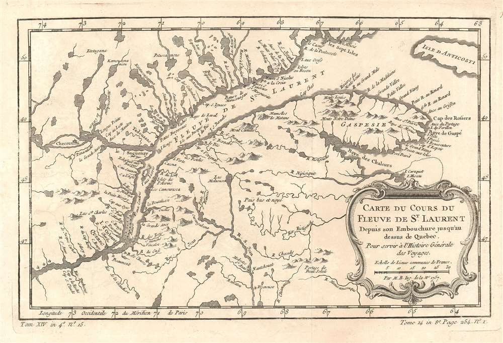
Carte du Cours du Fleuve de St. Laurent Depuis son Embouchure jusqu'au dessus de Québec.
1757 (dated) 8 x 12 in (20.32 x 30.48 cm) 1 :2850000
1757 (dated) 8 x 12 in (20.32 x 30.48 cm) 1 :2850000
Description
This is a 1757 Jacques-Nicolas Bellin map of part of the Saint Lawrence River and Québec, Canada. The map depicts the region from the Sainte Anne River to Anticosti Island and from Sept-Iles to the village of Freneuse. Numerous towns and villages are labeled, including Québec City and Tadoussac. Myriad small rivers leading into the Saint Lawrence are illustrated along both banks of the river from west of Québec City to the Gaspésie Peninsula. Innumerable lakes are also depicted.
Publication History
This map was created by Jacques-Nicolas Bellin for publication in Abbé Prévost's Histoire Générale des Voyages in 1757.Cartographer
Jacques-Nicolas Bellin (1703 - March 21, 1772) was one of the most important cartographers of the 18th century. With a career spanning some 50 years, Bellin is best understood as geographe de cabinet and transitional mapmaker spanning the gap between 18th and early-19th century cartographic styles. His long career as Hydrographer and Ingénieur Hydrographe at the French Dépôt des cartes et plans de la Marine resulted in hundreds of high quality nautical charts of practically everywhere in the world. A true child of the Enlightenment Era, Bellin's work focuses on function and accuracy tending in the process to be less decorative than the earlier 17th and 18th century cartographic work. Unlike many of his contemporaries, Bellin was always careful to cite his references and his scholarly corpus consists of over 1400 articles on geography prepared for Diderot's Encyclopedie. Bellin, despite his extraordinary success, may not have enjoyed his work, which is described as "long, unpleasant, and hard." In addition to numerous maps and charts published during his lifetime, many of Bellin's maps were updated (or not) and published posthumously. He was succeeded as Ingénieur Hydrographe by his student, also a prolific and influential cartographer, Rigobert Bonne. More by this mapmaker...
Condition
Very good. Even overall toning. Light wear along original fold lines. Blank on verso.
References
OCLC 937684837.