This item has been sold, but you can get on the Waitlist to be notified if another example becomes available, or purchase a digital scan.
1929 Hoelscher Pocket Map of St. Louis, Missouri (and suburbs)
StLouis-hoelscher-1929$100.00

Title
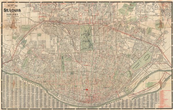
Map of City of St. Louis and Suburbs.
1939 (dated) 23.5 x 37 in (59.69 x 93.98 cm) 1 : 24000
1939 (dated) 23.5 x 37 in (59.69 x 93.98 cm) 1 : 24000
Description
An impressive 1929 large format pocket map of St. Louis, Missouri, and its suburbs. This map was drawn by H. W. Gross and published by Chas Hoelscher Maps of 203 Pine Street, St. Louis, Missouri. Centered on Forest Park, this map covers all of central St. Louis from the Mississippi River to the town border just north of the park. It also includes suburban regions to the north, west, and east. A street index appears just below of the Mississippi River at the base of the map. The map identifies rail lines, streets, parks, and important buildings.
Condition
Very good. Backed with archival tissue for stability. A few minor water stains.