1891 Shewey City Plan or Map of St. Louis, Missouri
StLouis-shewey-1891$650.00


Title
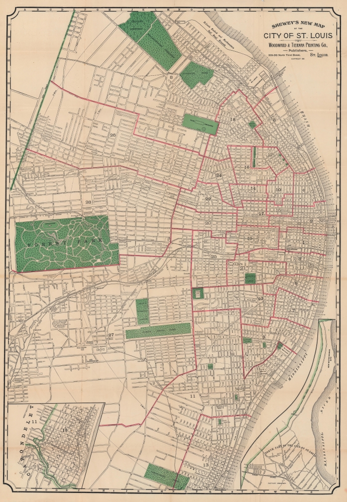
Shewey's New Map of the City of St. Louis.
1891 (dated) 37 x 25.5 in (93.98 x 64.77 cm)
1891 (dated) 37 x 25.5 in (93.98 x 64.77 cm)
Description
Detailing a city undergoing massive population growth, this is the 1891 Arista Shewey city plan or map of St. Louis, Missouri. By the turn of the 20th century, St. Louis emerged as the fourth-largest city in the United States with a booming economy and an extensive railroad network.
A Closer Look
Coverage embraces from St. Louis from Calvary Cemetery south to Carondelet Park and from Forest Park to the Mississippi River. The city's streets, parks, hospitals, schools, and other important buildings are noted. An inset of northern St. Louis occupies the lower right while another of city ward 13 and part of Carondelet appears in the lower left.Railroads
The many railroad lines running through St. Louis to the Mississippi are illustrated and labeled, underscoring the city's significance as a transportation and freight hub. Among the railroads are the Missouri Pacific Railroad; the St. Louis and San Francisco Railroad; the St. Louis, Kansas City, and Colorado Railroad; the St. Louis, Oak Hill and Carondelet Railroad, and the St. Louis, Iron Mountain, and Southern Railroad. The Illinois and St. Louis Railroad Bridge, today known as the Eads Bridge, appears near center. This bridge is the oldest steel truss bridge in the world and was built in part by Andrew Carnegie for the Illinois and St. Louis Bridge Company. The Merchants Bridge labeled farther upstream opened in 1889 after the Terminal Railroad Association lost control of the Eads Bridge and was concerned about a potential monopoly.Publication History and Census
This map was created by Arista C. Shewey and published in 1891 by the Woodward and Tiernan of St. Louis. We note two cataloged examples: Leventhal Map Center at the Boston Public Library and the University of Missouri - St. Louis.Cartographer
Arista C. Shewey (1843 - 19xx) was an American map publisher. Very little is known about Showy. He appears in St. Louis, Missouri, directories between 1880 and 1890, and in 1900 he was living in Chicago, Illinois. He lists his profession simply as 'maps' in the 1880 St. Louis city directory. It appears Shewey was married and had a son. More by this mapmaker...
Condition
Good. Wear along original fold lines. Old verso repairs at nearly every fold intersection. Closed margin fold separations repaired on verso.
References
Boston Public Library Leventhal Map Center G4164.S4 1891 .A27. OCLC 52972674.