This item has been sold, but you can get on the Waitlist to be notified if another example becomes available, or purchase a digital scan.
1758 Bellin Map of the Island of St. Lucia
StLucia-bellin-1758$125.00

Title
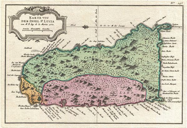
Karte von der Insel St. Lucia.
1758 (dated) 8.5 x 12 in (21.59 x 30.48 cm)
1758 (dated) 8.5 x 12 in (21.59 x 30.48 cm)
Description
An exceptionally fine example of the 1758 Dutch edition of Jacques N. Bellin's map of St. Lucia (St. Lucie), in the Lesser Antilles, West Indies. Oriented to the east, this map covers the entire island of St. Lucia with topography rendered in profile and color coding according region. A Dutch language title cartouche in the rococo ethic decorates the upper left quadrant.
Historically St. Lucia was part of the French West Indies, though, as this map went to press, the British, from their base in nearby Barbados, were eyeing the island's well developed sugar plantations. Several naval battles followed leading to a brief period of British rule in which African slaves were introduced to the island. Shortly thereafter the French once again asserted control of the Island and dominated the region until the events of the French Revolution. Today St. Lucia is a popular tourist destination and considered one of the most beautiful of the Windward Islands.
This map was prepared by J. N. Bellin for issue in the 1750 edition of Provost's L'Histoire Generale des Voyages. The present example is from the 1758 Dutch language edition published in Amsterdam. Though issued later than the French edition, the Dutch edition is highly desirable for its higher quality paper, incorporation of period color, and superior fully re-engraved map plates.
Cartographer
Jacques-Nicolas Bellin (1703 - March 21, 1772) was one of the most important cartographers of the 18th century. With a career spanning some 50 years, Bellin is best understood as geographe de cabinet and transitional mapmaker spanning the gap between 18th and early-19th century cartographic styles. His long career as Hydrographer and Ingénieur Hydrographe at the French Dépôt des cartes et plans de la Marine resulted in hundreds of high quality nautical charts of practically everywhere in the world. A true child of the Enlightenment Era, Bellin's work focuses on function and accuracy tending in the process to be less decorative than the earlier 17th and 18th century cartographic work. Unlike many of his contemporaries, Bellin was always careful to cite his references and his scholarly corpus consists of over 1400 articles on geography prepared for Diderot's Encyclopedie. Bellin, despite his extraordinary success, may not have enjoyed his work, which is described as "long, unpleasant, and hard." In addition to numerous maps and charts published during his lifetime, many of Bellin's maps were updated (or not) and published posthumously. He was succeeded as Ingénieur Hydrographe by his student, also a prolific and influential cartographer, Rigobert Bonne. More by this mapmaker...
Source
Prévost, A., Histoire Générale des Voyages, ou Nouvelle Collection de Toutes les Relations de Voyages par Mer et par Terre..., (Amsterdam: Pierre de Hondt ) 1746 - 1759.
Prévost's Histoire Générale des Voyages is a 15-volume compendium of travel literature initiated by Antoine François Prévost (Provost; 1697 - 1763) in 1746, intended as a universal history of exploration and geography. The initial publication, compiled from 1746 to 1759, spans 15 volumes and draws from a vast array of sources - travelers, explorers, missionaries, merchants, and diplomats - to present detailed narratives of significant global journeys. The work was initially published in Paris by Didot and offers ethnographic, political, religious, and natural observations about the peoples, cultures, flora, fauna, and geography. It is an ambitious attempt to organize knowledge about the world's diversity according to Enlightenment values, reflecting both scientific curiosity and imperial ideology. It functioned as both an informative reference and a literary work, influencing how European audiences understood and imagined distant lands. It proved extremely successful, and both reissues other publishers and pirate editions emerged, most notably Pierre de Hondt's 1747 Dutch edition and Jean-Franćois de la Harpe's 1780 abridged version. In addition to reissues of the original work, between 1768 and 1801, additional expanded volumes emerged, adding new voyages and histories. We have seen some sets with as many as 80 volumes. Over time, the Histoire générale des voyages became one of the most comprehensive and widely read travel collections of the 18th century, notable for blending factual reporting with the period's characteristic intellectual ambition.
Condition
Very good. Original platemark visible. Blank on verso.
References
Harvard Map Collection, G5110 1758 .B41.