This item has been sold, but you can get on the Waitlist to be notified if another example becomes available, or purchase a digital scan.
1891 Rand McNally Map of St. Paul and Minneapolis, Minnesota
StPaul-randmcnally-1893$60.00

Title
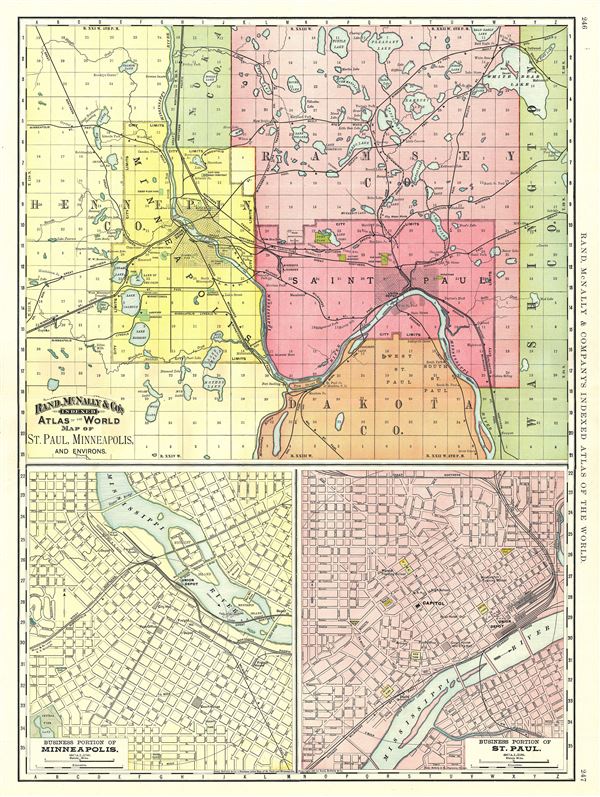
Map of St. Paul, Minneapolis, and Environs.
1891 (dated) 27 x 20 in (68.58 x 50.8 cm) 1 : 77000
1891 (dated) 27 x 20 in (68.58 x 50.8 cm) 1 : 77000
Description
A beautiful 1891 Rand McNally and Company map of St. Paul and Minneapolis, Minnesota. Divided into three parts, the top half of the sheet features a map of St. Paul, Minneapolis and environs. It covers from Hennepin County to Washington County, and notes lakes, railway lines, rivers, and other topographical features. The map also delineates survey grids and plats referencing the work of the U.S. Land Survey.
The map on the lower left quadrant of the sheet features the business portions of Minneapolis, while the map on the lower right details the business portions of St. Paul. Both the lower maps note individual streets, important buildings, parks, rivers, and other important landmarks.
This map was issued as plate nos. 246 and 247 in the 1893 edition of Rand McNally and Company's Indexed Atlas of the World- possibly the finest atlas Rand McNally ever issued.
Cartographer
Rand, McNally and Co. (fl. 1856 - present) is an American publisher of maps, atlases and globes. The company was founded in 1856 when William H. Rand, a native of Quincy, Massachusetts, opened a print shop in Chicago. Rand hired the recent Irish immigrant Andrew McNally to assist in the shop giving him a wage of 9 USD per week. The duo landed several important contracts, including the Tribune's (later renamed the Chicago Tribune) printing operation. In 1872, Rand McNally produced its first map, a railroad guide, using a new cost effective printing technique known as wax process engraving. As Chicago developed as a railway hub, the Rand firm, now incorporated as Rand McNally, began producing a wide array of railroad maps and guides. Over time, the firm expanded into atlases, globes, educational material, and general literature. By embracing the wax engraving process, Rand McNally was able to dominate the map and atlas market, pushing more traditional American lithographic publishers like Colton, Johnson, and Mitchell out of business. Eventually Rand McNally opened an annex office in New York City headed by Caleb S. Hammond, whose name is today synonymous with maps and atlases, and who later started his own map company, C. S. Hammond & Co. Both firms remain in business. More by this mapmaker...
Source
Rand McNally & Co., Rand, McNally & Co's Indexed Atlas of the World, (Chicago) 1893.
Condition
Very good. Original centerfold exhibits minor wear. Text on verso.
References
Rumsey 3565.124 (1897 edition). Philips (atlases) 1026 (1898 edition).