This item has been sold, but you can get on the Waitlist to be notified if another example becomes available.
1962 Placemat Map of St. Petersburg, Florida
StPetersburg-paterson-1962$87.50

Title
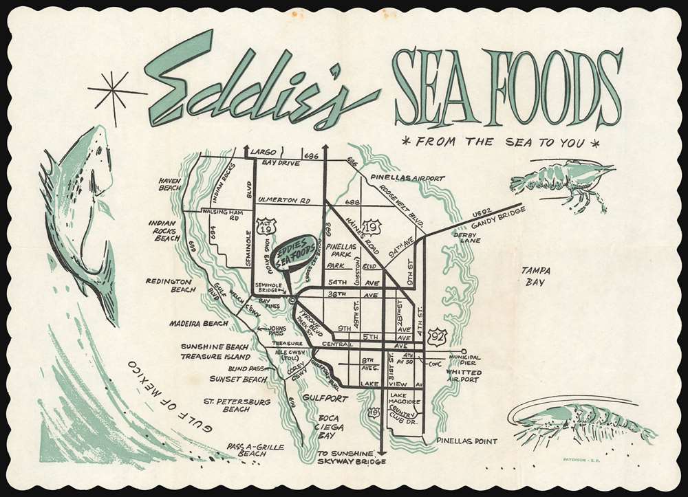
Eddie's Sea Foods *From the Sea to You*
1962 (undated) 9 x 13 in (22.86 x 33.02 cm)
1962 (undated) 9 x 13 in (22.86 x 33.02 cm)
Description
This 1962 placemat map of St. Petersburg, Florida is a promotional work for a seafood restaurant. Decorated with crawfish and other seafood, the centerpiece is a road map of St. Petersburg from its barrier islands on the Gulf Coast to the Tampa Bay shore, extending from Pinellas Point in the south to Bay Drive in the North. The map captures the city just prior to a series of major changes to its infrastructure: Boca Ciega Bay's landfill islands such as Capri, Paradise Island, and Yacht Club Estates did not yet exist, for example. The Pinellas Byway bridge does not appear here: it would not be completed until December, 1962. The Welch Causeway, connecting Madeira Beach with Seminole Boulevard, was built earlier that year, giving us the 1962 dating.
That bridge, unfortunately, was a notorious bottleneck between the Gulf shore and the rest of the city. Plans by the city to expand the bridge, almost universally welcomed, required the demolition of Storey's properties. (Storey's counterproposals to relocate the route northwards, or to fill in the offending portion of Boca Ciega Bay did not meet with success.) The new Seminole Bridge began construction in 1965, and was complete the next year. Following the loss of Eddie's Sea Foods, we see no further ventures by Mr. Storey. We have no confirmed dates for him; he may have been born in 1913, and appears to have still been listed in the St. Petersburg phone directory as late as 1998. He may yet live.
Eddie's Last Hurrah
At the center of this map is a drama directly related to the road-and-bridge building characterizing St. Petersburg in the early sixties. Prior to World War II, E. M. Storey had worked in automobile sales in Washington, D.C., but as a hobby had operated a handful of oyster boats in the Chesapeake. Wartime saw Storey captaining a tug in the Washington Naval Yard. At the end of the war, Storey and his wife sold his house and his business and relocated south on a 45-foot cabin cruiser, selecting St. Petersburg to settle and start a new seafood venture. He purchased land, and opened a wholesale seafood market and drive-in named Eddie's Sea Foods in 1946. Storey expanded to include dining room service as early as 1948, and over the next decade added a motel to the business. As indicated on the map, Eddie's was located on the shore at the east end of the Seminole Bridge.That bridge, unfortunately, was a notorious bottleneck between the Gulf shore and the rest of the city. Plans by the city to expand the bridge, almost universally welcomed, required the demolition of Storey's properties. (Storey's counterproposals to relocate the route northwards, or to fill in the offending portion of Boca Ciega Bay did not meet with success.) The new Seminole Bridge began construction in 1965, and was complete the next year. Following the loss of Eddie's Sea Foods, we see no further ventures by Mr. Storey. We have no confirmed dates for him; he may have been born in 1913, and appears to have still been listed in the St. Petersburg phone directory as late as 1998. He may yet live.
Publication History and Census
This placemat was printed by Paterson Paper (now Paterson Pacific Parchment Company), a commercial paper maker and printer in San Francisco, California specializing in products for the restaurant and baking industries. It is not known if the map and graphics were produced in-house by Paterson, by Eddie's Sea Foods, or by a third party. According to OCLC, no institution has this map catalogued in their collection.Cartographer
Paterson Paper was founded in 1923 in San Francisco, California to specialize in printing and converting paper products. Eventually they relocated to Sunnyvale California and in 1991, the company relocated to the city of Sparks, Nevada. Among their offerings to the restaurant industry have been placemats printed on a variety of themes, including maps. More by this mapmaker...
Condition
Very good. Slight creasing from folds. Minor food stain away from printed image.