This item has been sold, but you can get on the Waitlist to be notified if another example becomes available, or purchase a digital scan.
1906 Titcomb City Urban Planing Map of St. Petersburg, Florida
StPetersburg-titcomb-1906$4,750.00


Title
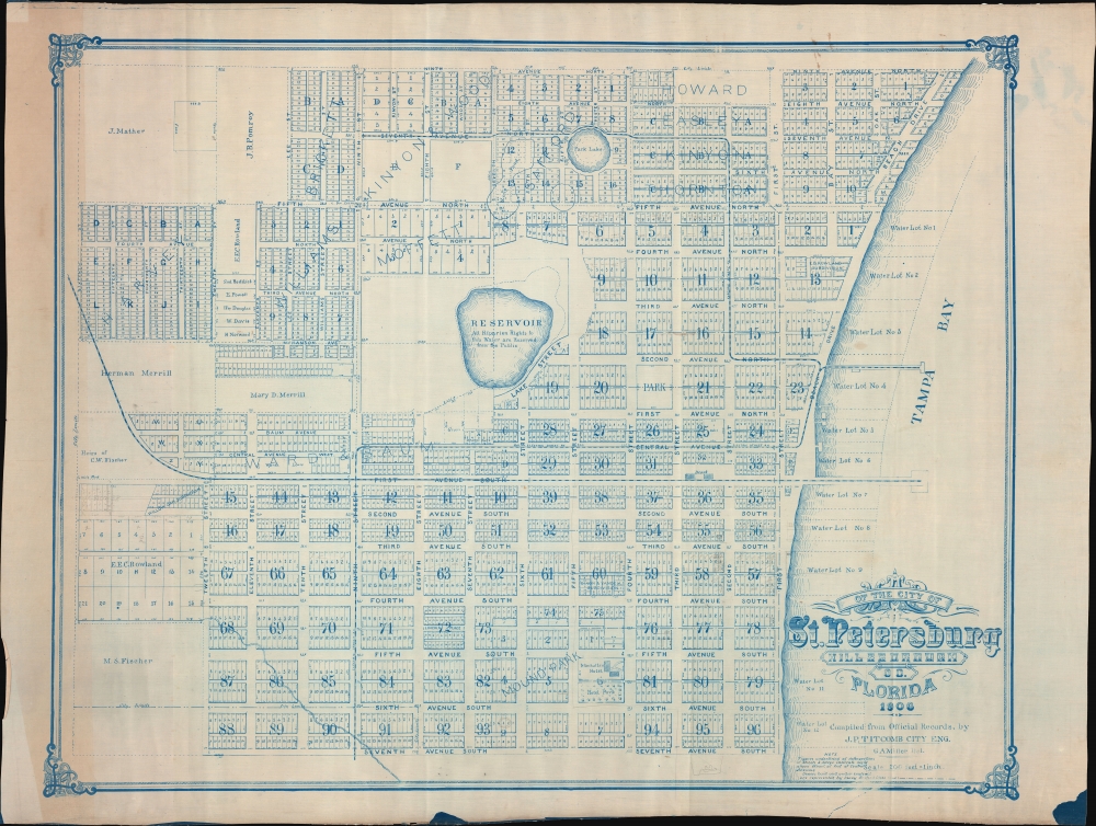
Map of the City of St. Petersburg Hillsborough Co. Florida 1906.
1906 (dated) 38 x 49 in (96.52 x 124.46 cm) 1 : 2400
1906 (dated) 38 x 49 in (96.52 x 124.46 cm) 1 : 2400
Description
An extraordinary 1906 wall map of St. Petersburg, Florida, issued at the height of its early 20th century development as a railroad and tourist town. The map was drawn by St. Petersburg's City Engineer, John Poore Titcomb, who took the position in 1901 and, in the year this map was issued, supervised the 1906 construction of the city's first sewer system - as identified here.
The map was printed as a diazo, a solar-reactive reprographic technique very similar to blueprints. While diazo prints were not commercially used before 1923, they were popular among surveyors and military cartographers. Like cyanotypes, production numbers are necessarily low, so it is unlikely that more than 10 of these were printed - likely less. The present example came from Titcomb's estate.
A Closer Look
The map is a reverse cyanotype or diazo, a specialty of Titcomb that he referred to as the 'blue process'. The map loosely follows in style if not content, with significantly broader coverage reflecting early 20th century growth, upon the G. A. Miller and A. L Hunt map of 1888 - considered the first map of St. Petersburg. Coverage here embraces from Ninth Avenue North to Seventh Avenue South, and from the city limits at Sixteenth Street to Tampa Bay. The map centers on the Reservoir, the reserved area around which is today's Campbell Park. Private real estate development is noted throughout, with developers named: Moffett, William Kinyon and Wood, Harvey, Pomroy, Mater, Howard, Fischer, and Brickett, among others. The newly developed sewer lines, Titcomb's signature project, are identified herein with thick dashed lines. Throughout there are additional manuscript annotations reflecting ongoing development.St. Petersburg - Historical Context
St. Petersburg, Florida, was founded in 1888, and Orange Belt Railway chose the site as its terminus the same year. It was subsequently incorporated as a town in 1892, with a population of 300. By 1903, when it was incorporated as a city, it was fast developing into one of Florida's major centers. The first decade of the 20th century saw massive investment in infrastructure, including electrified rail lines, city parks, a sewer system, and major port - nearly all of which was guided by Titcomb. The Orange Belt Railway made it one of the few cities in South Florida easily accessible by rail - and as such, it developed early as a tourism destination, with grand hotels and luxurious summer residences. By 1910, the population reached more than 10,000.Diazo Print or Whiteprint
The diazo print (whiteprint or diazo for short) is a photo reproductive technique best understood as a reverse cyanotype or blueprint. The process yields distinctive blue lines on white. Like cyanotypes, the diazo process gained popularity in architecture circles, where it was a simple and effective way to duplicate documents in the field. The earliest diazotypes appeared around 1880 and were adopted for military and field cartographic use from about 1895. The diazo process was commercialized in 1923, when the German firm, Kalle and Company, developed Ozalid, a patented diazo paper that made diazotyping even easier. By the 1950s, it supplemented cyanotypes as the reprographic technique of choice for technical drawings.Publication History and Census
This is the only known example of the present map, in its 1906 edition. We are aware of a very similar 1908 map in which some of the manuscript updates here - pointedly the J.C. Blocker development, are rectified to print. While we would not be surprised to learn that this map was updated annually, or exists in an earlier state, as of now we are unaware of it. More likely, this expanded plan was compiled specifically for Titcomb's sewer project, and is therefore the earliest large-scale map of St. Petersburg post-incorporation.The map was printed as a diazo, a solar-reactive reprographic technique very similar to blueprints. While diazo prints were not commercially used before 1923, they were popular among surveyors and military cartographers. Like cyanotypes, production numbers are necessarily low, so it is unlikely that more than 10 of these were printed - likely less. The present example came from Titcomb's estate.
Cartographer
John Poore Titcomb (April 7, 1861 - June 26, 1932) was a civil engineer active in Florida and later Maine in the late 19th and early 20th century. Titcomb was born in West Newbury, Massachusetts. In both 1885 and 1886 he received homestead patents in Florida, near Lake Kerr, and in 1887, he appears in the Jacksonville city directory as a Civil Engineer. Similarly, in 1887, we see an advertisement for his services as a Notary and Civil Engineer in the Palatka Daily News. There he promotes his skill with the 'Blue Process' of map reproduction. He married Mary B. Todd (1868 - ????) in 1891. In this same year he was doing railroad and real estate surveys in and around Amesbury. Titcomb likely gave up these grants following the great freezes of 1894 - 1895, which devastate the Florida citrus industry. From 1892, until about 1899, Titcomb served as the City Engineer for St. Petersburg, Florida. Around 1900, he relocated to Amesbury, Massachusetts, where he was active as a surveyor and in the local Masonic lodge. It is likely he spent his winters in St. Petersburg and retained real estate interests there throughout this period. Sometime in the 1920s he appears on voter rolls in California, but he must have returned to Amesbury, as he died there in 1931. More by this mapmaker...
Condition
Very good. On waxed silk. Reverse cyanotype. Slight toning left border.