This item has been sold, but you can get on the Waitlist to be notified if another example becomes available, or purchase a digital scan.
1852 Andrews Map of Florida, Cuba and the Gulf of Mexico
StraitsofFlorida-andrews-1852$325.00

Title
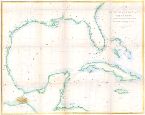
Map of the Straits of Florida and Gulf of Mexico. To accompany a report from the Treasury Department of Israel D. Andrews in obedience to the resolution of the Senate of March 8th, 1851.
1852 27.5 x 34 in (69.85 x 86.36 cm)
1852 27.5 x 34 in (69.85 x 86.36 cm)
Description
This is a rare large format coastal chart depicting the full coast of the Gulf of Mexico, Florida, the Bahamas, The Isthmus of Tehuantepec, Yucatan, Cuba and Jamaica. It was issued in 1852 to accompany Israel D. Andrews' report to the Senate. Depicts coastal cities and ports, offshore shoals, knolls, reefs, banks and other nautical hazards and some inland details, especially in the important overland crossing from Atlantic to Pacific of Tehuantepec, Mexico. Contemporary hand color. Andrews was the Consul of the United States for Canada and Trade and Commerce.
Cartographer
Israel de Wolf Andrews was the Consul of the United States for Canada and New Brunswick from 1851 - 1854. Little else is known about this elusive figure. More by this mapmaker...
Condition
Very Good condition. Two joined sheets. Professionally cleaned, flattened, and backed with archival linen. Minor discolorations on original fold-lines. Blank on verso. Contemporary color. Wide margins.