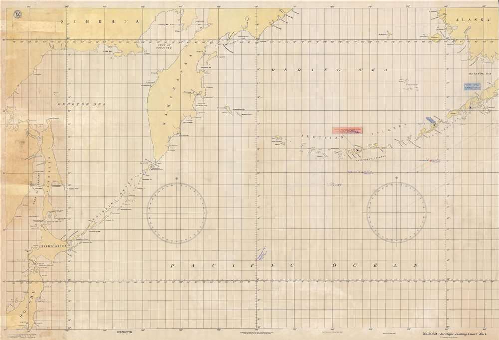
1939 U.S. Navy Hydrographic Office Chart of the Aleutian Islands and the North Pacific
StrategicPlottingChart-usnavy-1939$400.00


Title
No. 5050, Strategic Plotting Chart No. 4.
1939 (dated) 32.75 x 49 in (83.185 x 124.46 cm) 1 : 3400000
1939 (dated) 32.75 x 49 in (83.185 x 124.46 cm) 1 : 3400000
Description
This is a 1939 U.S. Navy Hydrographic Office chart of the Aleutian Islands and the North Pacific, with WWII Era manuscript annotations. Coverage extends from Siberia, Sakhalin, and northern Japan to Bristol Bay and southwestern Alaska.
War Games
Colored blue and orange and written in blue ink, these notations likely reference a war game undertaken by cadets at the U.S. Naval War College in 1940 or 1941. Our research indicates that cadets in both classes participated in war games in the Aleutian Islands early in the academic year.The War Game
Unfortunately we have been unable to directly link this piece to any specific exercise. Its use of blue and orange strongly suggests that it was part of a training exercise, because 'Orange' was the code name set aside for Japan in the U.S. Navy from just after World War I and 'Blue' was meant to denote American forces. Using this logic as a baseline, this likely means that the 'Orange Northern Raiding Force' identified in Kuluk Bay, Adak Island, was the Japanese force attacking the Aleutian Islands in this iteration of the Aleutian Islands war game. The American base at Dutch Harbor (the only base in the Aleutians until the Japanese occupied Attu and Kiska in June 1942) and Dolgoi Harbor were most likely meant to be the targets. Now, from here the specifics of the war game become more unclear. Four rendezvous points are colored orange and progress northwest through the Pacific. Since they are colored orange, the rendezvous points were likely meant for the Orange force, but it is unclear if they progress from 'A' to 'E' away from the Aleutians, or from 'E' to 'A' toward the Aleutians.Publication History and Census
This map was created and published by the U.S. Navy Hydrographic Office in August 1939 and bears manuscript notations written by an unknown hand that likely reference a U.S. Naval War College war game from 1940 or 1941. This is the only known cataloged example of this chart and the additional manuscript notations make it a truly rare find.Cartographer
United States Hydrographic Office (1866 - 1962) was a brach of he U.S. Navy that prepared and published maps, charts, and nautical books to aid in navigation. Before the establishment of the Hydrographic Office in 1866, U.S. navigators were almost entirely dependent on British charts. There had been a few private enterprises that had prepared and published charts, but none had been able to do so profitably. The Office was established 'for the improvement of the means of navigating safely the vessels of the Navy and of the mercantile marine, by providing, under the authority of the Secretary of the Navy, accurate and cheap nautical charts, sailing directions, navigators, and manuals of instructions for the use of all vessels of the United States, and for the benefit and use of navigators generally.' This way the Navy Department could furnish navy and merchant ships with charts illustrating the results of surveys and explorations undertaken by naval officers. The charts were priced to cover the cost of paper and printing alone, not preparation. Its main objective was to survey foreign coasts, as the Coast and Geodetic Surveys were responsible for surveying domestic waters. The Hydrographic Office was transferred from the Department of the Navy to the Department of Defense in 1949 and was replaced by the Naval Oceanographic Office in 1962. More by this mapmaker...
Condition
Good. Soiling. Manuscript notations. Closed tears extending two-and-one-quarter (2.25) inches into printed area from left margin professionally repaired on verso. Right side trimmed past border.