This item has been sold, but you can get on the Waitlist to be notified if another example becomes available.
1954 Delaye Pictorial Tourist Map of Southern Morocco
SudMarocain-delaye-1954$200.00


Title
Le Sud Marocain.
1954 (undated) 28.5 x 41.5 in (72.39 x 105.41 cm) 1 : 50000
1954 (undated) 28.5 x 41.5 in (72.39 x 105.41 cm) 1 : 50000
Description
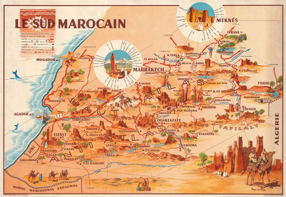
This is a c. 1954 Théophile-Jean Delaye pictorial map of southern Morocco. Oases, gorges, mountain peaks, and other wonders lure tourists with the region's enchanting mystique.
A Closer Look
Depicting from Meknes south to Spanish Morocco and the Sahara, cities, towns, villages, and incredible natural sites appear throughout. The largest are vignettes of Marrakech and Meknes encircled by white rings that include distances to cities throughout Morocco and Algeria, including Casablanca, Tangiers, Algiers, and Oran. Red lines highlight roads throughout, with distances provided in kilometers. A vignette of the historic fortified village of Marrakesh Ait Benhaddou (on the old caravan route between the Sahara and Marrakesh) appears in the lower right corner, complete with camel traders.Publication History and Census
This map was drawn by Théophile-Jean Delaye, published by the Office Marocain du Tourisme, and printed by Éditions Africaines Perceval in Rabat. We note a single cataloged example: the Bibliothèque Nationale de France. It occasionally appears on the private market.Cartographer
Théophile-Jean Delaye (1896 - 1970) was a French artist and military cartographer and was one of the first cartographers of modern Morocco. Born in Valence, he enlisted in the French army at the beginning of World War I and joined the Chasseurs alpins. By the end of the war Delaye had risen to the rank of lieutenant and graduated from Saint Cyr, the French military academy. In 1922, Delaye was sent to North Africa. First, he went to Tunisia and then to Morocco in 1924. As a topographic officer, he joined the service géographique du Maroc (Moroccan Geographical Service) and became its commanding officer in 1932. During his time with the service géographique (1925 to 1939) he made some of the first maps of Morocco and pioneered the use of aerial photography in the creation of maps and carried out 27 topographical missions. During these surveys, he continuously created beautiful drawings and paintings of the Moroccan landscape. He also worked with the publisher Éditions Arthaud and illustrated numerous works about Morocco and the Alps during the 1930s and 1940s. He fought in the North African and Italian campaigns during World War II and retired after the war as a lieutenant colonel. He returned to his home in Rabat and remained there until 1960, creating many tourist maps of Morocco and serving as the editor in chief of the Revue de géographie marocaine. He also served as the president of the Club alpin du Maroc, played a critical role in establishing the Toubkal National Park in 1942, and helped establish the first Moroccan ski championships at Oukaïmeden. During his 36 years in Morocco, Delaye created hundreds of images of Morocco. He left Morocco in 1960 and returned to his family home in the Drôme region of France. More by this mapmaker...
Condition
Good. Four closed tears each extending between 1/2 and 3/4 of an inch into the printed image from bottom margin. Closed margin tears repaired on verso.
References
Bibliothèque nationale de France FRBNF40697914.