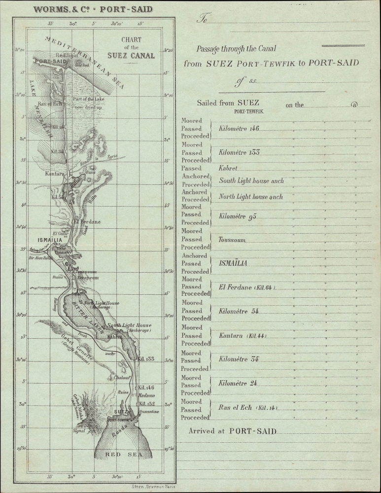
This item below is out of stock, but another example (left) is available. To view the available item, click "Details."
Details
1875 Stern Souvenir Map and Table of the Suez Canal
$300.00
1875 Stern Souvenir Map and Table of the Suez Canal
SuezCanal-stern-1875
Title
1875 (undated) 10.5 x 7.5 in (26.67 x 19.05 cm) 1 : 750000
Description
A Closer Look
A map and chart of the canal and environs between Port Said and Suez / Taofik (Tewfik) occupies the left. Anchorages and sandbanks are indicated on water, while on land, railways, roads, mountains, lighthouses, signals, ruins, settlements, and other features are noted. The Fresh Water Canal (Ismaïlia Canal or Sweet Water Canal), running parallel to the southern portion of the Suez Canal, was built before the main canal to provide fresh water to workers and to the growing city of Port Said. A grid of latitude and longitude lines overlies the map. The right half of the sheet is a table of landmarks and moorings, which allowed the passenger to track their ship's progress through the canal (from south to north).Suez Canal
The Suez Canal was built by the Suez Canal Company between 1859 and 1869, officially opening to maritime traffic on November 17, 1869. The canals cuts through the western Sinai Peninsula between the Mediterranean at Port Said and the Red Sea, at Suez. The completion of the canal allowed for significantly faster communication between European ports and the lucrative markets of Asia, as it nullified the need to round Africa.Work began on April 25, 1859, shortly after the developer Ferdinand de Lesseps obtained a concession from Sa'id Pasha, the Khedive of Egypt and Sudan. He created an international commission of 13 experts from 7 countries to construct the canal. Much of the construction force was conscripted labor under the corvée system, which was common in Egypt until 1882, when it was outlawed. The British initially opposed the canal out of fear it would disrupt English dominance of maritime trade, but in 1875, when Said Pasha's successor, Isma'il Pasha, ran up excessive debt, the British government acquired 44% of the canal. In 1888, it was declared a neutral zone under British protection (today, the canal is under Egyptian control). Combined with the completion of the Transcontinental Railroad in the United States six months earlier and a rail link across the Indian Subcontinent the following year, the Suez Canal signaled a new era of long-distance transportation and was quickly the subject of related cultural production, such as Jules Verne's Around the World in Eighty Days (1872).
Publication History and Census
This map and table were engraved by (Moïse) Stern in Paris for Worms and Co., a still-extant shipping company (operating as Worms Services Maritimes). Though printed in France for a French company, the text is (mostly) in English, perhaps because of the direction of the ship's voyage from India towards the Mediterranean. We are unable to locate any examples of this work in institutional collections. We know of one other example in private hands.Cartographer
Moïse Stern (1826 - 1915) was a French Alsatian Jewish engraver and printer based in Paris. Born in Haguenau, Stern apprenticed at the École israélite d'arts et métiers in Strasbourg, an institution he supported consistently after finding success. Upon completing his apprenticeship, Stern moved to Paris and worked with some of the most established engravers in the city. Stern teamed up with another engraver, Isidore Aumoitte (1797 - 1846), who had a small shop in the Galerie des Variétés. Sometime after Aumoitte's death, Stern fully took over the business and built a respected reputation as one of Paris' premier engravers, winning a gold medal at the Universal Exhibition in Paris in 1867 (he was made a chevalier in the Légion d’honneur the same year). Beginning in the 1890s, his son René (1862 - 1940) took on a greater role in running the business, which was renamed Stern et fils. The firm's boutique in the Passage des Panoramas / Galerie des Variétés was officially designated a historic landmark in 1974. Although its boutique was protected, the firm itself closed shop in 2015. More by this mapmaker...

