This item has been sold, but you can get on the Waitlist to be notified if another example becomes available, or purchase a digital scan.
1869 Wyld Official Map of the Suez Canal, Egypt
SuezCanal-wyld-1869$800.00

Title
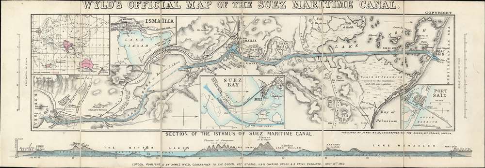
Wyld's Oficial Map of the Suez Maritime Canal.
1869 (dated) 8.25 x 23.5 in (20.955 x 59.69 cm) 1 : 300000
1869 (dated) 8.25 x 23.5 in (20.955 x 59.69 cm) 1 : 300000
Description
An extremely rare 1869 James Wyld map of the Suez Canal issued shortly before the Canal was opened. The canal was officially opened on November 17, 1869, and Wyld copyrighted this map on November 12, 1869, just in time to capitalize and general enthusiasm over canal's completion. The map covers the full extent of the Canal form the Mediterranean to the Red Sea. There are inset charts of Ismailia, Suez Bay, and Port Said. A further inset in the upper left, illustrates the canal within the context of the British Empire, whose possessions are highlighted in red. A profile section of the canal appears along the bottom border.
Work began on April 25, 1859, shortly after the developer Ferdinand de Lesseps obtained a concession from Sa'id Pasha, the Khedive of Egypt and Sudan. He created an international commission consisting of 13 experts from 7 countries to construct the canal. Much of the construction force was conscripted labor under the corvée system, which was common in Egypt until 1882, when it was outlawed. The British initially opposed the canal, out of fear it would disrupt English dominance of maritime trade, but in 1875 when Said Pasha's successor, Isma'il Pasha, ran up excessive debt, the British government acquired 44% of canal. In 1888, it was declared a neutral zone under British protection. Today the canal is under Egyptian control.
Suez Canal
The Suez Canal was constructed by the Suez Canal Company between 1859 and 1869, officially opening to maritime traffic on November 17th, 1869. The canals cuts through the western Sinai Peninsula between the Mediterranean at Port Said and the Red Sea, at Suez. The completion of the Canal allowed for significantly faster communication between European ports and the lucrative markets of Asia, as they nullified the need to round Africa.Work began on April 25, 1859, shortly after the developer Ferdinand de Lesseps obtained a concession from Sa'id Pasha, the Khedive of Egypt and Sudan. He created an international commission consisting of 13 experts from 7 countries to construct the canal. Much of the construction force was conscripted labor under the corvée system, which was common in Egypt until 1882, when it was outlawed. The British initially opposed the canal, out of fear it would disrupt English dominance of maritime trade, but in 1875 when Said Pasha's successor, Isma'il Pasha, ran up excessive debt, the British government acquired 44% of canal. In 1888, it was declared a neutral zone under British protection. Today the canal is under Egyptian control.
Publication History and Census
This map was copyrighted by James Wyld on November 12, 1869, just five days before the official opening of the Canal. We are aware of only a single edition. Surviving examples are scarce, with only 2 appearing in institutional collections. One at the British Library, and another at the Spertus Institute of Jewish Studies.Cartographer
Wyld (1823 - 1893) was a British publishing firm active throughout the 19th century. It was operated by James Wyld I (1790 - 1836) and his son James Wyld II (November 20, 1812 - 1887) were the principles of an English mapmaking dynasty active in London during much of the 19th century. The elder Wyld was a map publisher under William Faden (1749 - 1836) and did considerable work on the Ordinance Survey. On Faden's retirement in 1823, Wyld took over Faden's workshop, acquiring many of his plates. Wyld's work can often be distinguished from his son's maps through his imprint, which he signed as 'Successor to Faden'. Following in his father's footsteps, the younger Wyld joined the Royal Geographical Society in 1830 at the tender age of 18. When his father died in 1836, James Wyld II was prepared to fully take over and expand his father's considerable cartographic enterprise. Like his father and Faden, Wyld II held the title of official Geographer to the Crown, in this case, Queen Victoria. In 1852, he moved operations from William Faden's old office at Charing Cross East (1837 - 1852) to a new, larger space at 475 Strand. Wyld II also chose to remove Faden's name from all of his updated map plates. Wyld II continued to update and republish both his father's work and the work of William Faden well into the late 1880s. One of Wyld's most eccentric and notable achievements is his 1851 construction of a globe 19 meters (60 feet) in diameter in the heart of Leicester Square, London. In the 1840s, Wyld also embarked upon a political career, being elected to parliament in 1847 and again in 1857. He died in 1887 following a prolific and distinguished career. After Wyld II's death, the family business was briefly taken over by James John Cooper Wyld (1844 - 1907), his son, who ran it from 1887 to 1893 before selling the business to Edward Stanford. All three Wylds are notable for producing, in addition to their atlas maps, short-run maps expounding upon important historical events - illustrating history as it was happening - among them are maps related to the California Gold Rush, the New South Wales Gold Rush, the Scramble for Africa, the Oregon Question, and more. More by this mapmaker...
Condition
Very good. Old linen backing stable.
References
OCLC 557576445.