This item has been sold, but you can get on the Waitlist to be notified if another example becomes available, or purchase a digital scan.
1840 Burr Map of Sullivan County, New York
SullivanCounty-burr-1840$300.00

Title
Map of the County of Sullivan.
1840 (dated) 17.5 x 19 in (44.45 x 48.26 cm) 1 : 167000
1840 (dated) 17.5 x 19 in (44.45 x 48.26 cm) 1 : 167000
Description
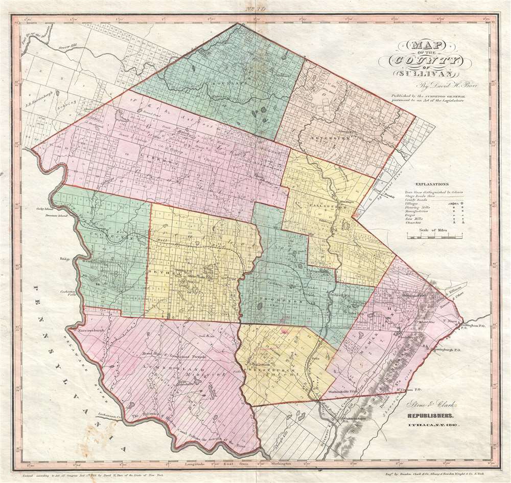
This is a rare 1840 David H. Burr map of Sullivan County, New York published by Stone and Clark. Providing a highly detailed illustration of Sullivan County, the map depicts the region from Pennsylvania to the Shawangunk Creek and from the northernmost point in Sullivan County to the Delaware River and the Shawangunk Mountains. Individual towns are illustrated, labeled, and shaded different colors to allow for easy differentiation. Each town is divided into numerous private land claims, some of which are identified by name. Villages, such as Thompsonville, Phillipsport, Fallsburgh, and Neversink are labeled, as is the county seat at Monticello. Mills, forges, manufactories, and churches are also noted, as are county roads and stage roads. The Delaware and Hudson Canal, though not illustrated, is labeled as following 'the margin' of the Delaware River near the bottom border. The Mount Hope and Lumberland Turnpike is also labeled, as are numerous brooks, streams, and ponds.
A Short History of Sullivan County and the Borscht Belt
Sullivan County was founded in 1809 after it was split from Ulster County and named for John Sullivan (1740 - 1795), who was a general in the Continental Army, a delegate to the Continental Congress, and a Governor of New Hampshire. In the late 19th century, the Industrial Revolution and the advent of factories driven by water power along the streams and rivers of Sullivan County led to an increase in population attracted by these jobs. Hamlets enlarged into towns. As industry restructured, many of those jobs left before the middle of the twentieth century. The economy changed again after that, shifting to a more tourist-based variety and benefiting from resorts established by European Jewish immigrants and their descendants in what became called the Borscht Belt. Resort hotels featured a wide variety of entertainers, some nationally known. At the beginning of this period, visitors traveled to the area by train, and later by automobile. The area's natural resources also provided a setting for numerous summer camps frequented by the children of immigrants and their descendants. By the late 1960s, family resort vacations had begun to lose their appeal among America's youth. Many of the hotels and resorts closed during the 1970s, and by the mid-1980s nearly all of them had shut their doors. The beloved classic Dirty Dancing takes place at a fictionalized version of one of these resorts.Publication History and Census
This map was created by David H. Burr in 1829 and republished by Stone and Clark in 1840 (present example). Per David Rumsey, this map is part of an unrecorded edition of Burr's An Atlas of the State of New York…, published in 1840 by Stone and Clark. We have been able to locate one other example of this 1840 edition of Burr's map of Sullivan County in the David Rumsey Map Collection at Stanford. An incomplete example of the 1840 Stone and Clark edition of Burr's An Atlas of the State of New York… is part of the collection at the New York Public Library.Cartographer
David Hugh Burr (August 18, 1803 - December 25, 1875) of one of the first and most important truly American cartographers and map publishers. Burr was born in Bridgeport Connecticut in August of 1803. In 1822 Burr moved to Kingsboro, New York to study law. A year and a half later he was admitted to the New York Bar association. Burr must have questioned his choice of careers because shortly after being admitted to the Bar, he joined the New York State Militia. Though largely untrained in the art of surveying, Burr was assigned to work under Surveyor General of New York, Simeon De Witt, to survey several New York Roadways. Seeing a window of opportunity, Burr was able to negotiate with the governor of New York at the time, De Witt Clinton, to obtain copies of other New York survey work in order to compile a map and Atlas of the state of New York. Recognizing the need for quality survey work of its territory, the government of New York heartily endorsed and financed Burr's efforts. The resulting 1829 Atlas of the State of New York was the second atlas of an individual U.S. state and one of the most important state atlases ever produced. Burr went on to issue other maps both of New York and of the United States in general. In cooperation with publishing firm of Illman & Pillbrow, he produced an important New Universal Atlas and, with J.H. Colton, several very important maps of New York City. In recognition of this work, Burr was appointed both "Topographer to the Post office" and "Geographer to the House of Representatives of the United States". Later, in 1855, Burr was assigned to the newly created position of Surveyor General to the State of Utah. Burr retired from the position and from cartographic work in general in 1857 when light of some of his financial misdeeds and frauds came to light. He was accused of submitting false expense reports and underpaying employees, among other indiscretions. More by this mapmaker...
Source
Burr, D., An Atlas of the State of New York… (Ithaca: Stone and Clark) 1840.
Condition
Very good. Light toning along original centerfold. Light wear along original centerfold. Blank on verso.
References
Rumsey 0105.040. OCLC 46794755.