1892 Rand McNally Map of Switzerland
Switzerland-randmcnally-1895$75.00

Title
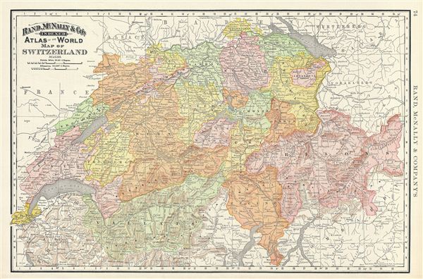
Map of Switzerland.
1892 (dated) 13 x 20 in (33.02 x 50.8 cm) 1 : 760320
1892 (dated) 13 x 20 in (33.02 x 50.8 cm) 1 : 760320
Description
This is a beautiful example of Rand McNally and Company's 1892 map of Switzerland. It covers the entirety of Switzerland or the Helvetic Republic divided into its constituent Cantons from Vaud to Grisons. After the creation of a federal constitution in 1848, Switzerland underwent a period of rapid social and economic development. The cantonal currencies were replaced by a single currency (the Swiss Franc) and many of the cantons subsequently established representative governments and instituted freedom of the press and trade. A year before this map was created; the Swiss constitution was revised to use the unique system of direct democracy. Color coded according to cantons, the map notes several towns, cities, rivers and various other topographical details with relief shown by hachure. This map was issued as plate no. 74 in the 1895 issue of Rand McNally and Company's Indexed Atlas of the World - possibly the finest atlas Rand McNally ever issued.
Cartographer
Rand, McNally and Co. (fl. 1856 - present) is an American publisher of maps, atlases and globes. The company was founded in 1856 when William H. Rand, a native of Quincy, Massachusetts, opened a print shop in Chicago. Rand hired the recent Irish immigrant Andrew McNally to assist in the shop giving him a wage of 9 USD per week. The duo landed several important contracts, including the Tribune's (later renamed the Chicago Tribune) printing operation. In 1872, Rand McNally produced its first map, a railroad guide, using a new cost effective printing technique known as wax process engraving. As Chicago developed as a railway hub, the Rand firm, now incorporated as Rand McNally, began producing a wide array of railroad maps and guides. Over time, the firm expanded into atlases, globes, educational material, and general literature. By embracing the wax engraving process, Rand McNally was able to dominate the map and atlas market, pushing more traditional American lithographic publishers like Colton, Johnson, and Mitchell out of business. Eventually Rand McNally opened an annex office in New York City headed by Caleb S. Hammond, whose name is today synonymous with maps and atlases, and who later started his own map company, C. S. Hammond & Co. Both firms remain in business. More by this mapmaker...
Source
Rand McNally & Co., Foreign Countries. Rand, McNally & Co's Indexed Atlas of the World (Complete in Two Volumes)…, (Chicago) 1895.
Condition
Very good. Text on verso.
References
Rumsey 3565.018 (1897 edition). Philip (atlases) 1026 (1898 edition).