1811 Manuscript Comparative Geological Chart of Caribbean Islands
TableauGeologique-unknown-1811$1,500.00

Title
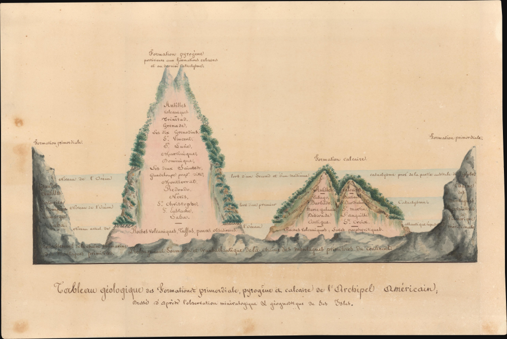
Tableau géologique des formations primordiale, pyrogène et calcaire de l’archipel américain; Dressé d’après l’observation minéralogique et géognostique de ces isles.
1811 (undated) 11.5 x 17 in (29.21 x 43.18 cm)
1811 (undated) 11.5 x 17 in (29.21 x 43.18 cm)
Description
This is a striking c. 1811 manuscript infographic view depicting geological formations and processes in the West Indies. It is the earliest such known image to focus on the West Indies. The whole is highly reminiscent of the works of the polymath Alexander von Humboldt, but cannot be positively linked to the famed polymath.
Shaded horizontal bands refer to geologic eras, separated by three great cataclysms which also correspond to levels of ocean depth and the three types of formations presented, a manifestation of the geological and paleontological theory of Catastrophism which was popular in the early 19th century.
It is possible that this work was produced by an early follower of Humboldt's ideas and methodology. In this case, a likely candidate would be another Alexander, the French physician, statistician, and scientist Alexandre Moreau de Jonnès (1778 - 1870), who published the 1822 book Histoire physique des Antilles Françaises, which begins with a lengthy discussion of the geology of the West Indies. In any event, this spectacular work is done entirely in manuscript, making it a unique creation.
A Closer Look
This sheet is more of an infographic than a map, though it is reminiscent of comparative maps of mountains that would become more common later in the 19th century. It is dedicated to representing the formation of limestone, other forms of rock, minerals, and volcanoes in the West Indies. At left, right, and bottom are the mountains which resulted from 'primordial formation' including those of the Greater Antilles (Cuba, Puerto Rico, Saint Domingue or Hispaniola, Jamaica), a set of submarine mountains in the Caribbean Sea, and the 'primitive' mountains of South America. A second set of peaks towards right are islands defined by limestone mountains, including Barbados, Tobago, Antigua, St. Martin, and St. Croix. The tallest peaks towards left are the 'volcanic Antilles,' including Trinidad, Grenada, Martinique, and Nevis.Shaded horizontal bands refer to geologic eras, separated by three great cataclysms which also correspond to levels of ocean depth and the three types of formations presented, a manifestation of the geological and paleontological theory of Catastrophism which was popular in the early 19th century.
Publication History and Census
This work is unsigned and undated, but very likely dates to the early 19th century. It resembles the types of stunning and innovative comparative infographic charts produced by Alexander von Humboldt in this era. We have been unable to find a corresponding example of this work in Humboldt's printed oeuvre, but it may be related to his 'Esquisse d'un tableau géologique de l'Amerique méridionale' (Journal de physique, 1801) an early article where he says he made two related sketches that were sent back to Madrid (Although German, Humboldt generally published in French to reach a wider audience). The handwriting here does not resemble other available examples of the great scientist's script, but this is a highly formalized image, likely a proof for publication, so that fact alone is inconclusive.It is possible that this work was produced by an early follower of Humboldt's ideas and methodology. In this case, a likely candidate would be another Alexander, the French physician, statistician, and scientist Alexandre Moreau de Jonnès (1778 - 1870), who published the 1822 book Histoire physique des Antilles Françaises, which begins with a lengthy discussion of the geology of the West Indies. In any event, this spectacular work is done entirely in manuscript, making it a unique creation.
Condition
Very good. Some spots of foxing and toning.