1950 Sylvain Pictorial Map of Tahiti
Tahiti-sylvain-1950$600.00

Title
Tahiti.
1950 (undated) 15.75 x 24.5 in (40.005 x 62.23 cm)
1950 (undated) 15.75 x 24.5 in (40.005 x 62.23 cm)
Description
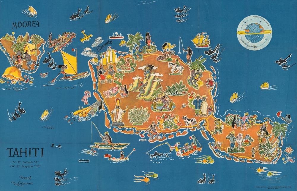
A curious 1950 pictorial map of Tahiti in French Polynesia by Jean Roucaute, printed by Photos Sylvain. It reflects the popular French romanticization of Tahiti as a otherworldly paradise, a perspective that can largely be attributed to the artist Paul Gaugin, who is referenced here several times.
The illustrations of people are highly symbolic, though Roucaute's exact intention is somewhat unclear. In depicting interactions between locals and Europeans, it is difficult to tell if he is critiquing a colonialist mindset, endorsing it, or simply pointing it out. At left, a portly, sunburned White man is fanned with a leaf by a native woman. Elsewhere, a native boat captain saves a White fisherman from falling into the water, a colonial official tries to explain a treatise on agriculture to a local farmer, and an 18th century French sea captain contemplates a statue of a nude local woman in the style of the Venus de Milo. At right, a European meant to be Paul Gaugin paints a scene including a native woman.
The ghastly looking figures at center standing in front of a church likely represent the assimilation or Europeanization of Tahitian culture. 'Authentic' indigenous culture - singing, boating, fishing - is portrayed as much more vibrant, though a figure towards bottom-left, likely a tahu'a or indigenous 'priest,' also appears as grey and sickly. The yellow-skinned figure towards right eating rice is likely a reference to descendants of Cantonese plantation workers brought to Tahiti in the 1870s.
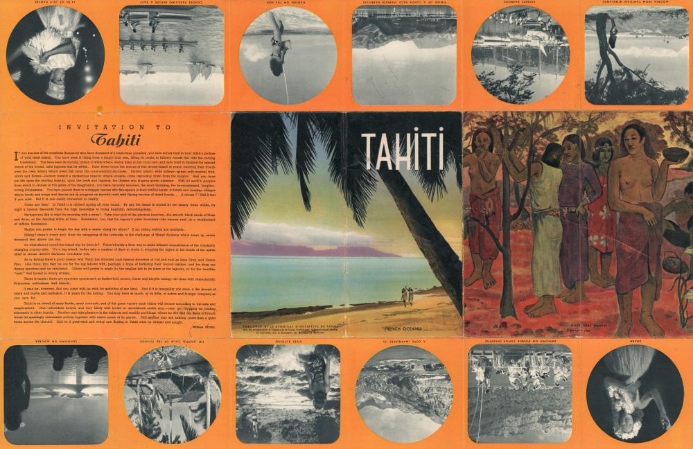
The verso includes photographs and more references to Gaugin, who famously spent most of the last part of his life in French Polynesia, including in Tahiti. Both the map and verso follow Gaugin in an idealized and highly sexualized portrayal of the islands and its people, 'the most charming, the brownskinned, laughter-loving Polynesians.'
A Closer Look
Taking in the islands of Tahiti and Moorea, a rich variety of human and animal figures populate the sheet. The islands' natural splendor and distinctive volcanic peaks, including Diadem Mountain at center, are included, as is the capital city of Papeete towards top-left. A globe at top-right indicates Tahiti's location near the equator.The illustrations of people are highly symbolic, though Roucaute's exact intention is somewhat unclear. In depicting interactions between locals and Europeans, it is difficult to tell if he is critiquing a colonialist mindset, endorsing it, or simply pointing it out. At left, a portly, sunburned White man is fanned with a leaf by a native woman. Elsewhere, a native boat captain saves a White fisherman from falling into the water, a colonial official tries to explain a treatise on agriculture to a local farmer, and an 18th century French sea captain contemplates a statue of a nude local woman in the style of the Venus de Milo. At right, a European meant to be Paul Gaugin paints a scene including a native woman.
The ghastly looking figures at center standing in front of a church likely represent the assimilation or Europeanization of Tahitian culture. 'Authentic' indigenous culture - singing, boating, fishing - is portrayed as much more vibrant, though a figure towards bottom-left, likely a tahu'a or indigenous 'priest,' also appears as grey and sickly. The yellow-skinned figure towards right eating rice is likely a reference to descendants of Cantonese plantation workers brought to Tahiti in the 1870s.
The verso includes photographs and more references to Gaugin, who famously spent most of the last part of his life in French Polynesia, including in Tahiti. Both the map and verso follow Gaugin in an idealized and highly sexualized portrayal of the islands and its people, 'the most charming, the brownskinned, laughter-loving Polynesians.'
Publication History and Census
This pictorial view or map was drawn by Jean Roucaute, printed by Photos-Sylvain in conjunction with the Imprimerie E. Desfossés-Néogravure, and published in 1950 by le Syndicat d’Initiative de Tahiti, with the Agence de la France d'outre-mer, le Commissariat Générale au tourisme and the Compagnie des Messageries Maritime. It is not noted among the collections of any institution and has only appeared on the market once in recent years.CartographerS
Jean Roucaute (fl. c. 1950 - 1951) was a French artist, cartographer, and scholar based in Tahiti. Little is known about his life and work, but at least one pictorial map and one cadastral survey are attributed to him, as well as a publication on the land regulations of French territories in the Pacific. He appears to have had an official or semi-official role in the administration of French Polynesia and most likely lived in Papeete. More by this mapmaker...
Adolphe Sylvain (1920 - 1991) was a French photographer, photojournalist, filmmaker, and publisher of photographs and other visual materials focusing on Tahiti. After having studied to be a civil engineer, Sylvain became deeply interested in Tahiti and was strongly influenced by the painter Paul Gaugin. Sylvain's works followed Gaugin's motif, using erotic depictions of native women as a means of expressing the idyllic nature of the island. Learn More...
Condition
Good. Original fold lines visible. Minor areas of surface pigment loss at fold lines and intersections.