This item has been sold, but you can get on the Waitlist to be notified if another example becomes available, or purchase a digital scan.
1777 Tupaia Indigenous Map of Tahiti and the Society Islands (in Russian)
TahitiSocietyIslands-tupaia-1777$1,000.00

Title
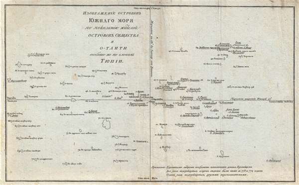
ИЗОБРАЖЕНІЕ ОСТРОВОВЪ ЮЖНАГО МОРЯ ПО ПОКАЗАНИЮ ЖИТЕЛЕЙ ОСТРОВОВЪ ОБЩЕСТВА И O-TAИTИ. / A Chart representing the Isles of the South Sea, according to the notions of the Inhabitants of O'Taheitee and the Neighboring Isles chiefly collected from the accounts of Tupaya.
1777 (undated) 8.5 x 13.5 in (21.59 x 34.29 cm)
1777 (undated) 8.5 x 13.5 in (21.59 x 34.29 cm)
Description
A significant discovery of considerable rarity, this is a c. 1777 Russian language version of the Tupaia Chart or map of the Society Islands and Tahiti. The map is based upon the indigenous cartography of Tupaia, a Tahitian navigator who drew this map in 1770 while onboard Captain Cook's ship, the H.M.S. Endeavour. Tupaia's Chart, as it is commonly known, is significant as both an illustration of traditional Polynesian hydrographic thinking and as indicative that Tahitian geographical knowledge was far greater than initially assumed.
Tupaia, Tahitian Navigator and Priest of the War God
Tupaia (c. 1725 - December, 26 1770) was a Tahitian navigator and war priest originally from the island of Ra'iatea in the Society Islands. Tupaia joined the crew of the Endeavour in July of 1769 on the insistence of the expedition's botanist, the English nobleman Sir Joseph Banks. Banks was astounded by the breadth and accuracy of Tupaia's hydrographic knowledge. During his life, Tupaia had navigated from Ra'iatea in short voyages to just 13 of neighboring islands. Nonetheless, through wisdom passed down from his grandfather, from a time when Ra'iateans sailed throughout Polynesia, he was able to provide sailing directions to some 70 distant islands. Tragically, Tupaia sickened and perished after less than a year on the Endeavour, but before he died, Banks convinced him to draw a map.
How the Map Was Made
The construction of the map probably proceeded as follows. Banks, or one of the ship's draftsman, would have drawn a cross centered on Tahiti, the largest geographical island in the region, then marked out the cardinal directions: North, South, East, and West. To this, the draftsman would have added the islands already known and mapped by both Cook and other Europeans. Afterwards, Banks asked Tupaia to add any additional information he was aware of. Thus, the present map, in which islands mapped by Cook are underlined twice, by other Europeans once, and the remainder of which were illustrated and identified by Tupaia.
Traditional Polynesian Cartography
It has recently been argued by scholars Anne di Piazza and Erik Pearthree that this map is in fact trying to be two things at once. A traditional European map built upon mathematical principals of scale and distance, and a traditional Polynesian representation of sailing directions. Polynesian navigation was based upon the idea that wherever one started form was the 'center' and to navigate to another islands, one simply identified and followed the correct trajectory. Traditionally distance was not clearly identified in Polynesian sailing instructions, rather it was described as how many days it would take to reach destination A or B, factors that varied according to currents and prevailing winds.
According to Piazza and Pearthree,
All in all, Tupaia mapped some 78 islands for Cook and Banks, some known, some not. Cook made no attempt to visit or map the additional islands placed by Tupaia and the map was never included in the official narrative of the voyage. Nonetheless, Tupaia's chart was preserved in two versions. One, the original manuscript, was kept by Jospeh Banks and rediscovered in 1955, relatively recently. Another better-known version, of which the present map is a variant, was engraved by William Faden and issued by John Reinold Forster, the ship's naturalist, in his 1778 account of the voyage.
Today Forster's account is extremely rare and in most examples this map has been expunged. That the present map is from a previously unknown Russian edition of Forster's account only adds to its extraordinary rarity. Although examples of the Forster English language narrative Observations made during a voyage round the World do appear in instructional collections, we have identified no known examples of the Russian edition, and no separate original print examples of the map, in any language, either in institutional collections or in the market history of the last 30 years.
Tupaia, Tahitian Navigator and Priest of the War God
Tupaia (c. 1725 - December, 26 1770) was a Tahitian navigator and war priest originally from the island of Ra'iatea in the Society Islands. Tupaia joined the crew of the Endeavour in July of 1769 on the insistence of the expedition's botanist, the English nobleman Sir Joseph Banks. Banks was astounded by the breadth and accuracy of Tupaia's hydrographic knowledge. During his life, Tupaia had navigated from Ra'iatea in short voyages to just 13 of neighboring islands. Nonetheless, through wisdom passed down from his grandfather, from a time when Ra'iateans sailed throughout Polynesia, he was able to provide sailing directions to some 70 distant islands. Tragically, Tupaia sickened and perished after less than a year on the Endeavour, but before he died, Banks convinced him to draw a map.
How the Map Was Made
The construction of the map probably proceeded as follows. Banks, or one of the ship's draftsman, would have drawn a cross centered on Tahiti, the largest geographical island in the region, then marked out the cardinal directions: North, South, East, and West. To this, the draftsman would have added the islands already known and mapped by both Cook and other Europeans. Afterwards, Banks asked Tupaia to add any additional information he was aware of. Thus, the present map, in which islands mapped by Cook are underlined twice, by other Europeans once, and the remainder of which were illustrated and identified by Tupaia.
Traditional Polynesian Cartography
It has recently been argued by scholars Anne di Piazza and Erik Pearthree that this map is in fact trying to be two things at once. A traditional European map built upon mathematical principals of scale and distance, and a traditional Polynesian representation of sailing directions. Polynesian navigation was based upon the idea that wherever one started form was the 'center' and to navigate to another islands, one simply identified and followed the correct trajectory. Traditionally distance was not clearly identified in Polynesian sailing instructions, rather it was described as how many days it would take to reach destination A or B, factors that varied according to currents and prevailing winds.
According to Piazza and Pearthree,
Cook, in his own words, believed Tupaia was drawing a map. Tupaia seems indeed to have tried to include distance in his plotting diagrams, thereby going beyond the traditional system of representation. Cook clearly remained fixed in his Cartesian world, adding cardinal points to Tupaia’s Chart. But both could look at the manuscript and see their own system represented: Cook reading islands on a grid and Tupaia reading islands radiating out from different centres.Versions of Tupaia's Map
All in all, Tupaia mapped some 78 islands for Cook and Banks, some known, some not. Cook made no attempt to visit or map the additional islands placed by Tupaia and the map was never included in the official narrative of the voyage. Nonetheless, Tupaia's chart was preserved in two versions. One, the original manuscript, was kept by Jospeh Banks and rediscovered in 1955, relatively recently. Another better-known version, of which the present map is a variant, was engraved by William Faden and issued by John Reinold Forster, the ship's naturalist, in his 1778 account of the voyage.
Today Forster's account is extremely rare and in most examples this map has been expunged. That the present map is from a previously unknown Russian edition of Forster's account only adds to its extraordinary rarity. Although examples of the Forster English language narrative Observations made during a voyage round the World do appear in instructional collections, we have identified no known examples of the Russian edition, and no separate original print examples of the map, in any language, either in institutional collections or in the market history of the last 30 years.
Cartographer
Tupaia (c. 1725 - December 26, 1770), also known as Tupaea or Tupaya, was a Tahitian navigator, artist, and arioi, or priest, of the war god 'Oro. He was born on the island of Ra'iatea near Ha'amanino Harbour, in the Society Islands. Following in a family tradition he became an ariori priest for the Taputapuatea marae. Tupaia was trained in the fare-'ai-ra'a-'upu, or schools of learning, about the origin of the cosmos, genealogies, the calendar, proverbs and histories. Additionally, his grandfather passed on to him traditional secrets of Tahitian oceanic navigation. When Ra'iatea was invaded by warriors from BoraBora in 1763, he fled to Tahiti where he became a prominent priest. When the English under Captain James arrived in June of 1769, he became fascinated by the strange Europeans. He attached himself to Samuel Wells and alter Joseph Banks. Under the patronage of Banks, but against Cook's better judgment, Tupaia joined the crew of the H. M . S. Endeavour. During his short stint on the Endeavour, he completed several watercolors, helped with navigation, and drew an important map of the Society Islands, the first examples of indigenous Polynesian cartography to make its way to Europe. Nonetheless, Tupaia remained unpopular with Cook, but had his grudging admiration, as described by Joseph Marra, a midshipman on the Endeavour,
Toobia ... was a man of real genius, a priest of the first order, and an excellent artist: he was, however, by no means beloved by the Endeavour's crew, being looked upon as proud and austere, extorting homage, which the sailors who thought themselves degraded by bending to an Indian, were very unwilling to pay, and preferring complaints against them on the most trivial occasions.With Tupaia's help the Endeavour made its way to Australia where they landed at Botany Bay in April of 1770. In November of that same year, the Endeavour landed in Batavia for repairs. There Tupaia contracted either dysentery or malaria from which he died shortly thereafter on December 26, 1770. More by this mapmaker...
Condition
Very good. Some soiling. Even toning.