This item has been sold, but you can get on the Waitlist to be notified if another example becomes available.
1964 Rand McNally City Plan or Map of Tampa and St. Petersburg, Florida
TampaStPetersburg-randmcnally-1964$100.00

Title
Tampa St. Petersburg.
1964 (dated) 28.75 x 17.5 in (73.025 x 44.45 cm) 1 : 40550
1964 (dated) 28.75 x 17.5 in (73.025 x 44.45 cm) 1 : 40550
Description
This is a 1964 Rand McNally city plan or map of Tampa and St. Petersburg, Florida. With Tampa on one side and St. Petersburg on the other, both cities garner the attention to detail necessary for both maps to be effective aids to motorists.
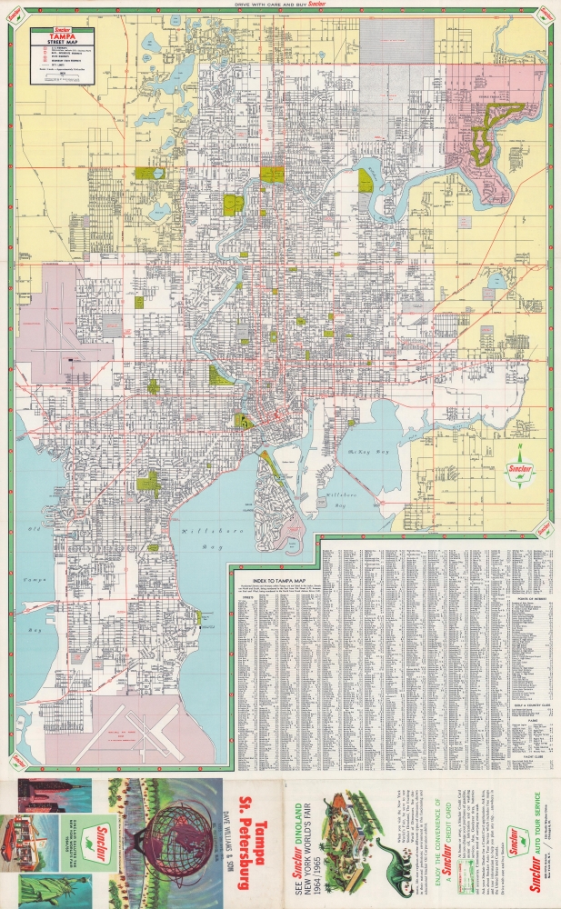
Tampa
Depicting the city in detail, streets, parks, lakes, rivers, and bays are all illustrated. Red emphasizes schools, hospitals, the public library, government buildings, the University of South Florida, and the University of Tampa. Tampa International Airport appears near the left border and MacDill Air Force Base is included at bottom left. An extensive alphabetic street index occupies the lower right and is followed by an index of points of interest, golf and country clubs, parks, and yacht clubs.St. Petersburg
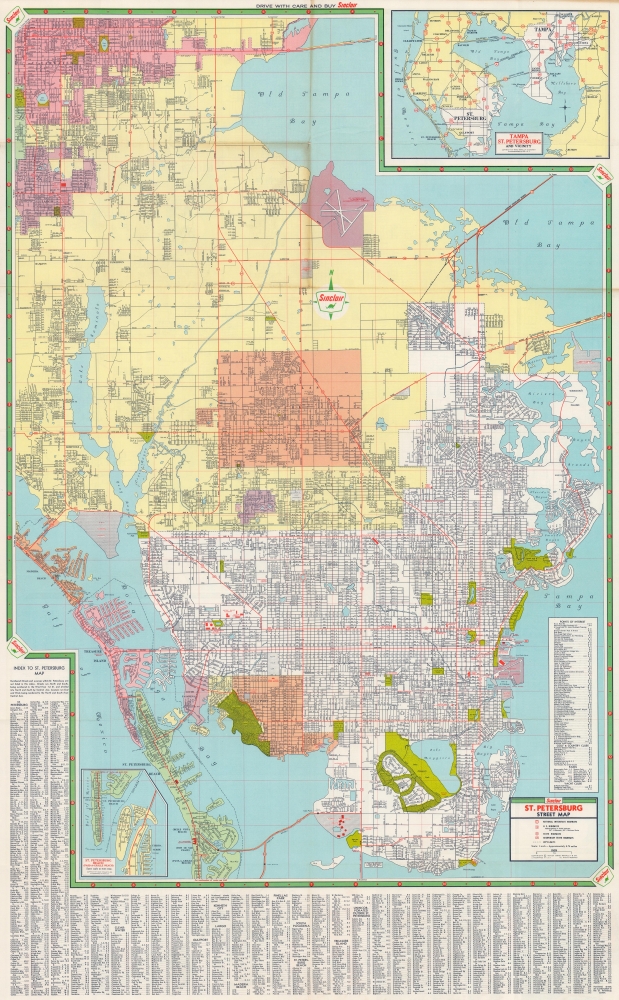
Encompassing from Clearwater south to Point Pinellas and Pass-a-Grille Beach, the map of St. Petersburg includes the same level of detail as above. Schools, hospitals, museums, and other points of interest are emphasized, including the Atlantic Coast Line railroad station. Streets are illustrated, with an alphabetic index framing the map's left and bottom edges. An inset in the lower left extends the map south to include the rest of Pass-a-Grille Beach, St. Petersburg Beach, and Tierra Verde.Publication History and Census
This map was created and published by Rand McNally and Company in 1964 and distributed by Sinclair Oil. This is the only cataloged example of this edition of this map of which we are aware.Cartographer
Rand, McNally and Co. (fl. 1856 - present) is an American publisher of maps, atlases and globes. The company was founded in 1856 when William H. Rand, a native of Quincy, Massachusetts, opened a print shop in Chicago. Rand hired the recent Irish immigrant Andrew McNally to assist in the shop giving him a wage of 9 USD per week. The duo landed several important contracts, including the Tribune's (later renamed the Chicago Tribune) printing operation. In 1872, Rand McNally produced its first map, a railroad guide, using a new cost effective printing technique known as wax process engraving. As Chicago developed as a railway hub, the Rand firm, now incorporated as Rand McNally, began producing a wide array of railroad maps and guides. Over time, the firm expanded into atlases, globes, educational material, and general literature. By embracing the wax engraving process, Rand McNally was able to dominate the map and atlas market, pushing more traditional American lithographic publishers like Colton, Johnson, and Mitchell out of business. Eventually Rand McNally opened an annex office in New York City headed by Caleb S. Hammond, whose name is today synonymous with maps and atlases, and who later started his own map company, C. S. Hammond & Co. Both firms remain in business. More by this mapmaker...
Condition
Very good. Light wear along original fold lines. Map of Tampa on recto and map of St. Petersburg on verso.