This item has been sold, but you can get on the Waitlist to be notified if another example becomes available, or purchase a digital scan.
1670 De Wit Map of Israel, Palestine, or the Holy Land
TerraSancta-dewit-1670$475.00

Title
Terra Sancta, sive Promissionis, olim Palestina.
1670 (undated) 18.5 x 22.25 in (46.99 x 56.515 cm) 1 : 600000
1670 (undated) 18.5 x 22.25 in (46.99 x 56.515 cm) 1 : 600000
Description
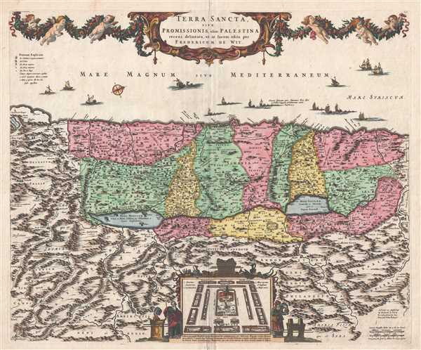
This is a c. 1670 Frederick de Wit map of the Holy Land, Israel, or Palestine. The map depicts the region from 'Arabia' to 'Syria' and from the Mediterranean Sea to Ammon, modern day Jordan. The Holy Land itself is divided into the regions occupied by the Twelve Tribes of Israel, and each region is labeled and shaded a different color to allow for easy differentiation. Innumerable cities, towns, and other settlements are illustrated and labeled, including Jerusalem, Bethlehem, and Nazareth. Major roads are illustrated, along with rivers and lakes. The Sea of Galilee and the Dead Sea are depicted, with the four destroyed cities of Sodom, Gomorrah, Adma, and Zeboim burning in the Dead Sea. A plan of the Temple of Solomon is situated at the center of the bottom border, with the Arc of the Covenant illustrated above the plan.
This map was produced by Frederick de Wit and published c. 1670.
This map was produced by Frederick de Wit and published c. 1670.
Cartographer
Frederik de Wit (1629 - 1706) was a Dutch Golden Age cartographer active in the second half of the 17th and the early 18th centuries. De Wit was born of middle class Protestant stock in the western Netherlandish town of Gouda. He relocated to Amsterdam sometime before 1648, where he worked under Willem Blaeu. His first attributed engraved map, a plan of Haarlem for Antonius Sanderus' Flandria Illustrata, was issued around this time. He struck out on his own in 1654. The first chart that De Wit personally both drew and engraved was most likely his 1659 map of Denmark, REGNI DANIÆ Accuratissima delineatio Perfeckte Kaerte van ‘t CONJNCKRYCK DENEMARCKEN. His great wall map of the world and most famous work, Nova Totius Terrarum Orbis Tabula appeared one year later. Following the publication of his wall map De Wit quickly rose in prominence as a both cartographer and engraver. He married Maria van der Way in 1661 and through her became a citizen of Amsterdam in 1662. Around this time he also published his first major atlas, a composite production ranging in size from 17 to over 150 maps and charts. Other atlases and individual maps followed. In 1689 De Wit was granted a 15 year Privilege by the Dutch States General. (An early copyright that protected the recipient's rights to print and publish.) He was recognized with the honorific 'Good Citizen' in 1694. De Wit died in 1706 after which his wife Maria continued publishing his maps until about 1710. De Wit's son, Franciscus, had no interest in the map trade, instead choosing to prosper as a stockfish merchant. On her own retirement, Maria sold most De Wit maps and plates at a public auction. Most were acquired by Pieter Mortier and laid the groundwork for the 1721 rise of Covens and Mortier, the largest Dutch cartographic publishing house of the 18th century. More by this mapmaker...
Condition
Very good. Verso repair to centerfold separations. Blank on verso.
References
OCLC 898127038.