This item has been sold, but you can get on the Waitlist to be notified if another example becomes available, or purchase a digital scan.
1856 Burr Map of the Territory of Utah Including the Great Salt Lake
TerritoryUtah-burr-1856$175.00

Title
Map Showing the extent of Surveys in the Territory of Utah.
1856 (dated) 34 x 16 in (86.36 x 40.64 cm) 1 : 300000
1856 (dated) 34 x 16 in (86.36 x 40.64 cm) 1 : 300000
Description
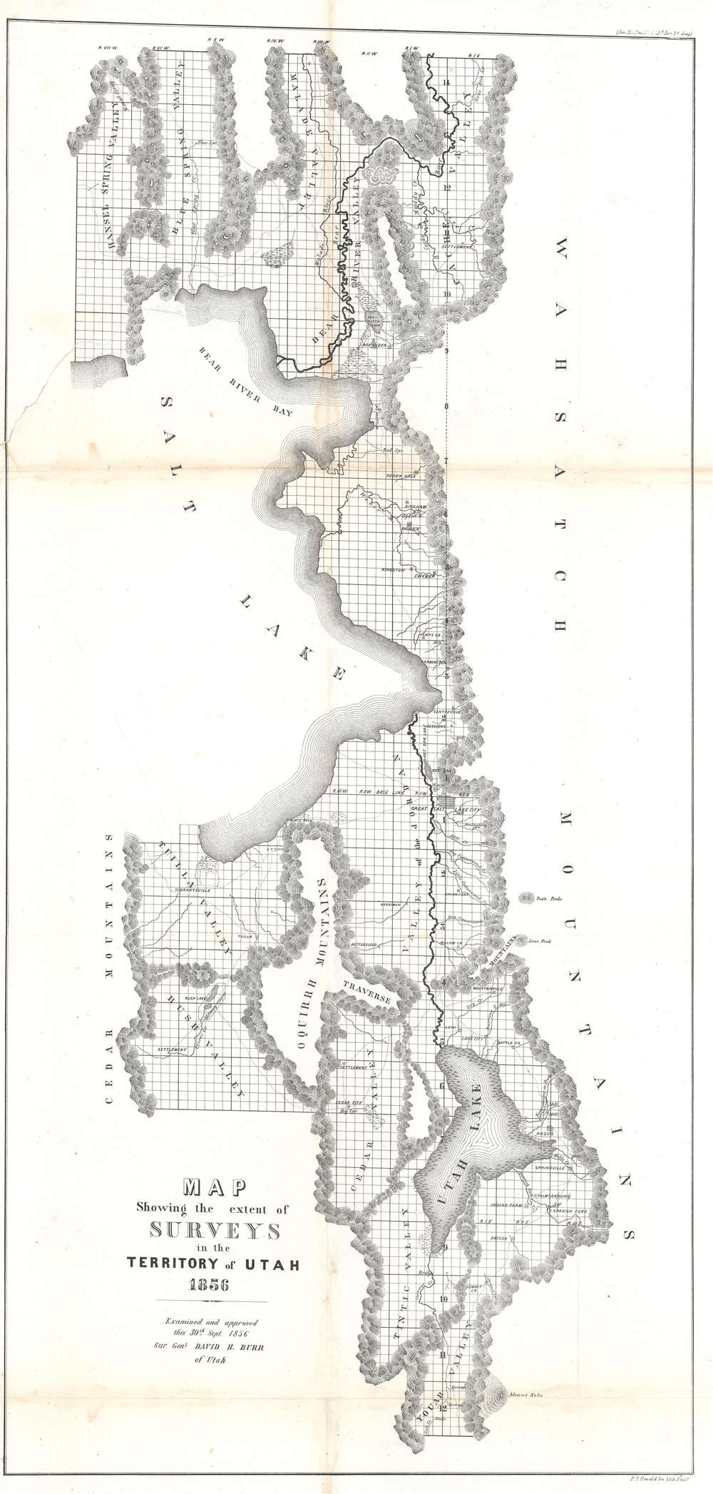
An important early map of Utah, this 1856 David Burr map highlights the eastern part of the Great Salt Lake and the vicinity. The map depicts the region from Hansel Spring Valley and the Cedar Mountains to the Wahsatch Mountains and from Malade Valley to Youab Valley. Mountain ranges, lakes, and smaller chains of hulls separate valleys throughout the region. These mountain ranges form the natural parries to the surveys accomplished by David Burr, then the Surveyor General of Utah, and his predecessors. These natural obstacles are the only areas not shown as having been surveyed, noted by the grid of the Public Land Survey System then in use in the United States. Cities, towns, and villages are identified as well, including Salt Lake City, Ogden, and Provo.
David Burr and Utah
David Burr was dispatched to Utah in July 1855 with orders to execute an accurate survey of the Utah Territory. Upon his arrival, he was immediately suspected by the Mormon population of being a spy for the federal government. Mormons feared government officials, partly due to the murder of the church's founder Joseph Smith in 1847 and the persecution the church's members had faced in Missouri and Illinois. Burr had his mail intercepted and read by state officials and was threatened when the letters contained derogatory statements about the government in Utah. Members of his survey team had to work under guard, while another, Joseph Troskowlawski, was beaten so badly that he was nearly paralyzed. Preachers even evoked Burr and his fellow surveyors by name in their Sunday sermons. By 1857 Burr and his team had fled the territory and President Buchanan sent in federal troops. After a two year standoff in which there was not much fighting, the sides agreed to an end to the Utah War and a new territorial government was installed.Publication History
This map was created by David Burr and published as part of a Congressional Report in 1856.CartographerS
David Hugh Burr (August 18, 1803 - December 25, 1875) of one of the first and most important truly American cartographers and map publishers. Burr was born in Bridgeport Connecticut in August of 1803. In 1822 Burr moved to Kingsboro, New York to study law. A year and a half later he was admitted to the New York Bar association. Burr must have questioned his choice of careers because shortly after being admitted to the Bar, he joined the New York State Militia. Though largely untrained in the art of surveying, Burr was assigned to work under Surveyor General of New York, Simeon De Witt, to survey several New York Roadways. Seeing a window of opportunity, Burr was able to negotiate with the governor of New York at the time, De Witt Clinton, to obtain copies of other New York survey work in order to compile a map and Atlas of the state of New York. Recognizing the need for quality survey work of its territory, the government of New York heartily endorsed and financed Burr's efforts. The resulting 1829 Atlas of the State of New York was the second atlas of an individual U.S. state and one of the most important state atlases ever produced. Burr went on to issue other maps both of New York and of the United States in general. In cooperation with publishing firm of Illman & Pillbrow, he produced an important New Universal Atlas and, with J.H. Colton, several very important maps of New York City. In recognition of this work, Burr was appointed both "Topographer to the Post office" and "Geographer to the House of Representatives of the United States". Later, in 1855, Burr was assigned to the newly created position of Surveyor General to the State of Utah. Burr retired from the position and from cartographic work in general in 1857 when light of some of his financial misdeeds and frauds came to light. He was accused of submitting false expense reports and underpaying employees, among other indiscretions. More by this mapmaker...
Peter Stephen Duval (1804 - February 8, 1886) was a prominent Philadelphia lithographer. He immigrated to Philadelphia from France in 1831 to take a job as a lithographer at the Philadelphia firm owned by Cephas Childs. In 1837, Childs retired and Duval took over the business. Over the course of the next thirty years, Duval would have several business partners including the Swiss-American engravers Charles and Frederick Bourquin (1808 - 1897). In 1857 his son Steven C. Duval joined the business. Peter Duval retired in 1869 but continued to be involved in his company until his death in 1886. Learn More...
Condition
Good. Backed on archival tissue for stability. Closed tear extending 11 inches from left margin into printed area professionally repaired on verso. Tight left margin. Toning and soiling along original fold linesBlank on verso.
References
OCLC 10702815.