This item has been sold, but you can get on the Waitlist to be notified if another example becomes available, or purchase a digital scan.
1933 Dallas Morning News Map of Texas
Texas-dallasmorningnews-1933$250.00


Title
A Map of Texas / Highway Map of Texas.
1933 (dated) 20 x 25.5 in (50.8 x 64.77 cm) 1 : 2000000
1933 (dated) 20 x 25.5 in (50.8 x 64.77 cm) 1 : 2000000
Description
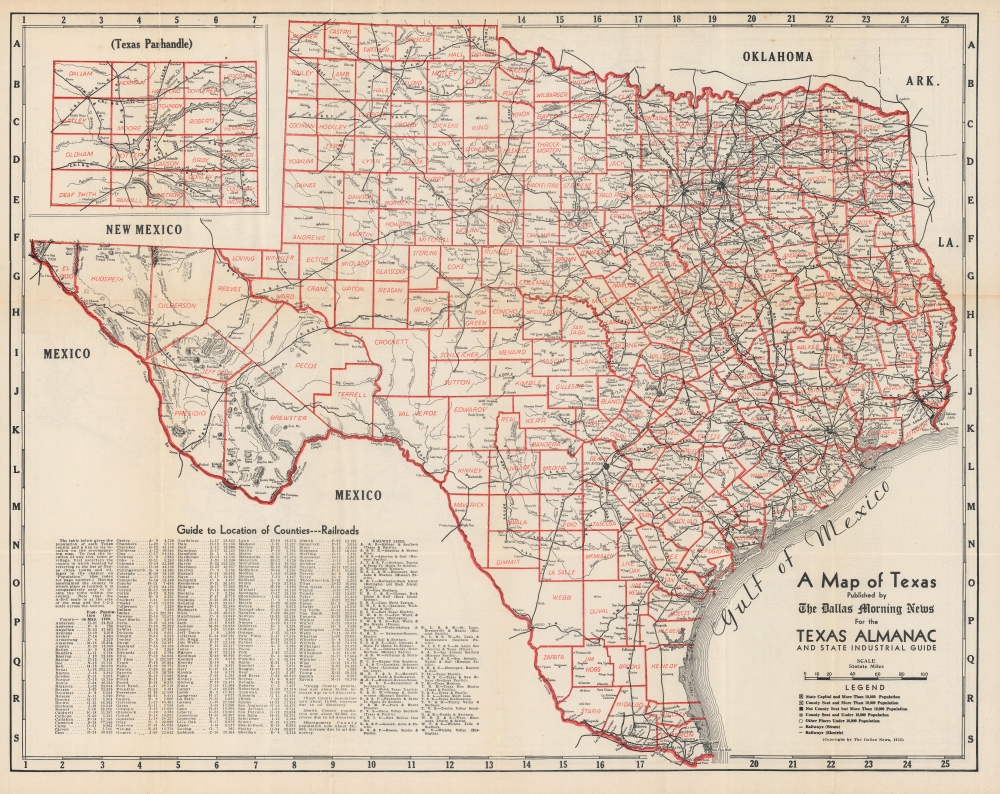
An impressive double-sided map of Texas, published in 1933 by the Dallas Morning News, highlighting the state's extensive rail and road infrastructure.
The verso displays a similar map of the state's growing highway network. Aside from the numbering of state and federal highways, details are provided on the nature and quality of roads, including those under construction or proposed (conditional designation). The centrality of the cities in the 'Texas Triangle' (San Antonio, Houston, and Dallas-Fort Worth, along with Austin, Waco, and other cities) in the state's highway network is immediately evident.
A Closer Look
A railroad and county map of Texas occupies the recto. Black lines trace railroad lines throughout the state, all of which are labeled and noted as either steam or electric. Counties are identified and delineated, including in an inset of the Texas Panhandle at top-left. A grid surrounds the map, corresponding to an index of counties and railroad lines in the lower left corner. Cities of various sizes, waterways, and elevation are also indicated.The verso displays a similar map of the state's growing highway network. Aside from the numbering of state and federal highways, details are provided on the nature and quality of roads, including those under construction or proposed (conditional designation). The centrality of the cities in the 'Texas Triangle' (San Antonio, Houston, and Dallas-Fort Worth, along with Austin, Waco, and other cities) in the state's highway network is immediately evident.
The Pan-American Highway
Also notable here is the Pan-American Highway, extending from Laredo eventually to Mexico City. Originally conceived as a railway in the late 19th century, the equivalent highway was still a relatively recent concept at the time of this map's publication. By improving existing highways and constructing new ones, it was hoped that one could travel on good roads from Alaska to Tierra del Fuego. Though never fully completed, routes connecting the United States (and, by extension, Canada) to Mexico City were already drivable at the time of the project's conception, and the North American portion, from Alaska through Mexico to the border of Guatemala, was operational by 1950.Publication History and Census
This map was created and published by the Dallas Morning News for the Texas Almanac and State Industrial Guide in 1933. The maps are not independently cataloged in the holdings of any institution, while the entire Texas Almanac is only noted among the holdings of the Texas State Historical Association.Cartographer
The Dallas Morning News (1885 - present) is a daily newspaper published in Dallas, Texas, and since its founding has generally been the newspaper with the highest circulation in that city. The company was founded in 1885 as a spin-off of the Galveston Daily News by Alfred Horatio Belo, a Civil War veteran who was an officer in the Confederate army before moving to Texas and becoming involved in the newspaper industry. Belo found great success, first with the Galveston Daily News and then with the Dallas Morning News (managed by longtime and trusted employee George Bannerman Dealey), largely because he embraced telegraphy, railroads, and later telephones as a means of rapidly communicating information that could be immediately incorporated into news print. The newspaper's parent company was named after Belo for many years but in 2021 changed its name to DallasNews Corporation in light of Belo's service in the Confederate army. More by this mapmaker...
Condition
Good. Light wear and toning along fold lines. Repaired split at center-top on verso.