This item has been sold, but you can get on the Waitlist to be notified if another example becomes available, or purchase a digital scan.
1836 James / Lee Map of the Republic of Texas in the Year it was Founded
Texas-lee-1836-2$3,000.00

Title
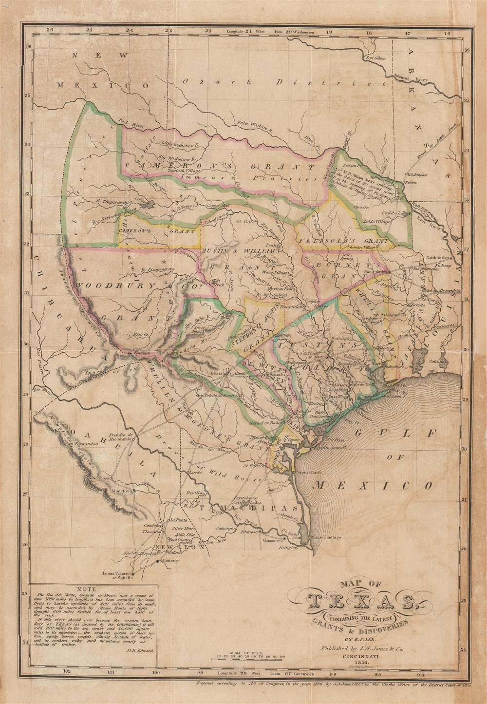
Map of Texas, containing the latest Grants and Discoveries by E. F. Lee.
1836 (dated) 13 x 9.25 in (33.02 x 23.495 cm) 1 : 4435200
1836 (dated) 13 x 9.25 in (33.02 x 23.495 cm) 1 : 4435200
Description
The rare 1836 Edmund F. Lee map of Texas produced for David Barnett Edward's History of Texas - a seminal work published on the eve of the March 1836 Texan Revolution and founding of the Republic of Texas. The map is loosely derived from the Stephen Austin map, the only readily available source at the time, but has been reduced and revised by Lee for smaller format publication. It unveils Texas extending from the Sabine to the Nueces River and from Corpus Christi to the Red River. A note in the lower left expresses the Texan ambition to extend the boundary west as far as the Rio Grande. The map notes several early Texas Empresario Land Grants, including: 'McMullen and McGlone', Woodbury, Cameron (2), 'Austin and Williams', Austin, DeWitt, Austin's Colony, De Leon, Burnet, Powers, Whelin, Zavallo, and Felisola.
Texas Empresario Land Grants
In the early 19th century, Spain instituted a series of reforms intended to settle and develop Texas, the most significant of which occurred in 1820, when it began to allow colonists of any religion (previously they had to be Catholic) to settle. The only colonist to receive land under the Spanish system was Moses Austin (1761 - 1821), who claimed his grant in 1820, only to die a year later in 1821. In that same year, 1821, the Mexican War of Independence (1810 - 1821) ended with Mexican independence from Spain. The new Mexican government continued the reforms, instituting the Texas Empresario system. Stephen F. Austin (1793 - 1836) took over his father Moses's grant and began an aggressive campaign to draw English speaking protestant settlers to Texas. Austin's efforts were aided by the Mexican Provisional Government, who approved the 1824 General Colonization Law authorizing all heads of household who were citizens or immigrants to Mexico to claim land. After the law passed, the government was inundated with requests by foreign speculators to establish colonies - many of whom received grants of their own. In the wake of the Panic of 1819, the United States underwent an extended period of inflation marked by soaring land prices. Texas, with vast tracks of arable land, warm climate, and free grant system, became a very attractive prospect. Austin's drive to populate Texas with English speaking settlers was thus enormously successful. Conflicts between the English protestant 'Emprasarios' and the Catholic Mexican government ultimately led to the Seccession of Texas (1836) and the Mexican American War (1846 - 1848).Texas Borders
In the lower left Edward adds an interesting note regarding the Texan ambition to expand the boundaries of Texas westward to the Rio Grande,If this river [Rio Grande] should ever become the western boundary of TEXAS (as desired by its inhabitants,) it will add 100 miles to its sea coast and 50,000 square miles to its superfices.Texas would indeed take this step in the coming months, with the Texan Revolution and the founding of the Republic of Texas. The borders of the Republic of Texas were in dispute from the earliest days of the Texan Revolution. The Republic-claimed borders followed the Treaties of Velasco between the newly created Texas Republic and Mexican leader, Antonio López de Santa Anna. The treaties established an eastern boundary following the 1819 Adams-Onís Treaty between the United States and Spain, which established the Sabine River as the eastern boundary of Spanish Texas and western boundary of the Missouri Territory. The Republic's southern and western boundary with Mexico was more nuanced. Texas claimed the Rio Grande del Norte as its western and southernmost border, while Mexico argued for a boundary much further east at the Nueces River. When Texas was annexed into the United States, the agreement followed the Republic claimed boundary, thus absorbing Mexican claimed territory as far west as Santa Fe. This escalated already existing tensions between the United States, the former Republic of Texas, and Mexico, ultimately triggering for the Mexican-American War (1846 - 1848).
Republic of Texas
The Republic of Texas was a short-lived nation established in March of 1836 when it seceded from Mexico. Following the independence of Mexico from Spain, the American Stephen Fuller Austin led a group of 300 Empresarios to settle Texas, near Austin, where they received a grant from the Mexican government. As more Americans moved to Texas, resentment and strife began to build between the American settlers and Mexican authorities. This and other factors ultimately led to the Texan Revolution in 1835 and the declaration of Texan independence in 1836. Texas remained an independent republic until it joined the United States ten years later in 1846.Publication History and Census
This map was prepared for publication in David B. Edward's The History of Texas; or, The Emigrant's, Farmer's, and Politician's Guide to the Character, Climate, Soil, and Productions of that Country, one of the seminal early works on Texas. The map was drawn by E. F. Lee and published in Cincinnati by J. A. James. It can only have been published in January or February of 1836, as it notes Col. Benjamin Rush Milam's (1788 - 1835) death at the December 10, 1835, Texan storming of Bexar, but predates the March 1836 Texan Revolution. We note examples of the separate map at the Sam Houston State University and the Family History Library. The book is well represented institutionally, but it is unclear if the represented works are the first edition or a more common 1975 reissue. Scarce on the market.CartographerS
Robert E. Lee (Jan 19, 1807 - October 12, 1870) was an American career military officer most famous for commanding the Confederate Army of Northern Virginia during the American Civil War. Lee's brilliance as a military commander, despite his adamant opposition to both slavery and succession, nearly led to Confederate victory in the Civil War. His military achievements and significance are far too great for us to cover here. His role as a cartographer is on the other hand often overlooked. Lee was born to an aristocratic Virginia family that unfortunately fell on hard times in his youth. As a young man Lee attended Extern View School and later West Point Military Academy. His focus was engineering and after graduating he joined the Army Corps of Engineers. Initially Lee was stationed at Cockspur Island, Georgia, where he worked on plans to construct a fort to protect the Savannah River. Later he helped to survey the Ohio-Michigan Boundary. Promoted to First Lieutenant Lee was assigned to supervise engineering work on St. Louis Harbor and to map Des Moines and Rock Island Rapids, both major obstacles to commercial navigation on the Mississippi. Promoted to Captain for his successes he became resident engineer at Fort Hamilton. With the outbreak of the Mexican-American war Lee earned numerous distinctions, emerging form the war as one of America's boldest and most brilliant military commanders. In 1859 he put down John Brown's slave revolt at Harper's Ferry. With the election of Abraham Lincoln and the outbreak of the American Civil War, Lee took on his most significant role as commander of the Confederate Army of Northern Virginia. The rest is, as they say, history. More by this mapmaker...
David Barnett Edward (1797 - 1870) was a Scottish-American educator, administer and explorer most associated with Texas. Edward was born in Forfarshire, Scotland. He lived in the West Indies and Columbia before immigrating to the United States in 1819. He worked as a teacher at the Academy of Alexandria, Louisiana before being transferred to the Gonzales Seminary at the DeWitt Colony, Texas. Around 1830, Edward participated in an exploratory mission around Texas, during which he formed a generally negative view of the English-speaking Empresarios then settling Texas. His subsequent work, The History of Texas: or, The Emigrant's, Farmer's, and Politician's Guide to the Character, Climate, Soil and Productions of that Country, written from 1831 to late 1835, and issued early in 1836, was issued on the eve of the Texan Revolution (March 1836). The work is detailed and based on first-hand knowledge, but generally pro-Mexican, anti-Anglo-Texan, and while thus unpopular in its day, is today considered one of the seminal publications on Texas. Around 1835, Edward, hated in Texas for his work, moved to Cincinnati, Ohio. He lived here until his 1870 death in Wheelersburg. Learn More...
Joseph Allen James (May 17, 1807 - March 27, 1882) was a bookseller, engraver, stereotype founder, and publisher active in Cincinnati in the early to late 19th century. He was born in Newark, New Jersey. His firm, J. A. James and Company was based at 1 Baker Street, between Walnut and Vine. Additionally, he partnered with his brother, Uriah Pierson James (1811 - 1889) in 'J.A. and U.P. James Company', also a stereotype foundry. He was also a partner in the printing concern 'James and Gazlay'. James died at Fort Monroe, Virginia in 1882. Learn More...
Curtis Miller Doolittle (August 26, 1799 - June 1, 1849) was an American artist, printer, and engraver. He was born in Westfield, Connecticut, the son of Amos Doolittle (1776 - 1858). Based upon the dates, this is not Amos Doolittle (1754 - 1832) the great American engraver, but may be his son, 'A. B. Doolittle', making Curtis Miller Doolittle his grandson. He relocated to Cincinnati, Ohio, sometime in the 1830s. From 1836, he partnered with Samuel Bishop Munson (1806 - 1880), likely a cousin, to found the bank note and map engraving firm of 'Doolittle and Munson.' Learn More...
Samuel Bishop Munson (May 29, 1806 - April 18, 1880) was an American engraver based in New Haven, Connecticut and later Cincinnati, Ohio. Munson was born in New Haven, Connecticut and studied engraving under Simeon Smith Jocelyn (1799 - 1879). He relocated to Cincinnati in 1836, immediately establishing a business partnership with Curtis Miller Doolittle (1799 - 1849), 'Doolittle and Munson', engravers of maps and bank notes. In 1838, he married Hannah Selina Sellew (1814 - 1861). Learn More...
Source
Edward, David, The History of Texas; or, The Emigrant's, Farmer's, and Poitician's Guide... (Cincinnati: J. A. James and Co.) 1836.
Condition
Good. Overall toning. Some verso repairs to old seam splits. Upper right margin extended.
References
OCLC 849516372. Day, James M., Maps of Texas, 1527-1900, #388. Howes, W., U.S.iana (1650-1950): A Selective Bibliography in which are Described 11,620 Uncommon and Significant Books Relating to the Continental Portion of the United States, #E-48. Sabin, J., A Dictionary of Books Relating to America: from its Discovery to the Present Time, #21886. Streeter (Texas) #1199. Storm, Colton, A Catalogue of the Everett D. Graff Collection of Western Americana, #1208.