This item has been sold, but you can get on the Waitlist to be notified if another example becomes available, or purchase a digital scan.
1854 Mitchell Map of Texas
Texas-mitchell-1854$375.00

Title
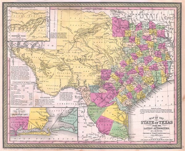
Map of the State of Texas from the Latest Authorities.
1854 (dated 1852) 13 x 16 in (33.02 x 40.64 cm)
1854 (dated 1852) 13 x 16 in (33.02 x 40.64 cm)
Description
A fine example of S. A. Mitchell and J. H. Young's important 1854 map of Texas. Mitchell's map covers the entire state of Texas from the Red River Valley to the Rio Grande, and from El Paso to the Louisiana border. Texas's northern panhandle is included via an inset in the upper left quadrant. The whole is engraved and colored in Mitchell's distinctive style with green border work and vivid pastels. Political and topographical features are noted and color coded with elevation rendered by hachure.
Though published as part of Mitchell's 1854 New General Atlas, this map is in fact unchanged from the 1852 state, as suggested by the copyright. Mitchell ordered this map re-engraved following the Compromise of 1850 in which, for monetary compensation, Texas agreed to surrender its claims to much of modern day New Mexico. Annotations in the left quadrants discuss the navigability of the Rio Grande for trade, the history of El Llano Estacado (Staked Plain), and note the route of Apache and Comanche incursions into Mexico. In the lower left quadrant there is an inset Map of the Vicinity of Galveston City. In the mid-19th century Galveston was one of the largest ports in the United States until devastated by a hurricane in 1900. Following the disaster, Galveston never revived as major maritime and commercial center.
This map was drawn by J. H. Young and prepared by S. A. Mitchell for publication by the Philadelphia firm of Thomas Cowperthwait & Co. as plate no. 25 in the 1854 edition of Mitchell's New General Atlas. Dated and copyrighted, 'Entered according to act of Congress in the year 1852 by Thomas Cowperthwait & Co. in the Clerk's office of the Eastern District of Pennsylvania.'
Samuel Augustus Mitchell (March 20, 1792 - December 20, 1868) began his map publishing career in the early 1830s. Mitchell was born in Bristol, Connecticut. He relocated to Philadelphia in 1821. Having worked as a school teacher and a geographical writer, Mitchell was frustrated with the low quality and inaccuracy of school texts of the period. His first maps were an attempt to rectify this problem. In the next 20 years Mitchell would become the most prominent American map publisher of the mid-19th century. Mitchell worked with prominent engravers J. H. Young, H. S. Tanner, and H. N. Burroughs before attaining the full copyright on his maps in 1847. In 1849 Mitchell either partnered with or sold his plates to Thomas, Cowperthwait and Company who continued to publish the Mitchell's Universal Atlas. By about 1856 most of the Mitchell plates and copyrights were acquired by Charles Desilver who continued to publish the maps, many with modified borders and color schemes, until Mitchell's son, Samuel Augustus Mitchell Junior, entered the picture. In 1859, S.A. Mitchell Jr. purchased most of the plates back from Desilver and introduced his own floral motif border. From 1860 on, he published his own editions of the New General Atlas. The younger Mitchell became as prominent as his father, publishing maps and atlases until 1887, when most of the copyrights were again sold and the Mitchell firm closed its doors for the final time. Learn More...
Source
Mitchell, S. A., A New Universal Atlas Containing Maps of the various Empires, Kingdoms, States and Republics Of The World, (Thomas Cowperthwait & Co., Philadelphia) 1854.
Condition
Very good condition. Even overall toning.
References
Phillips (Atlases) 814.