This item has been sold, but you can get on the Waitlist to be notified if another example becomes available, or purchase a digital scan.
1864 Mitchell Map of Texas
Texas-mitchell-1864$200.00

Title
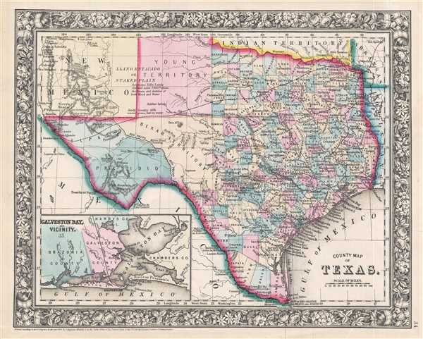
County Map of Texas.
1864 (dated 1860) 11 x 14 in (27.94 x 35.56 cm) 1 : 4300000
1864 (dated 1860) 11 x 14 in (27.94 x 35.56 cm) 1 : 4300000
Description
This is S. A. Mitchell Junior's 1864 map of Texas and part of New Mexico. The map depicts the region from western New Mexico to Arkansas and Louisiana and from the Indian Territory and northern Texas to the Rio Grande River and Mexico. Highly detailed, notations concerning railroads, topographical features, and cities are included. Color coded at the county level, each county is labeled and includes the county seat. Bexar, Young, Presidio, and El Paso Counties exhibit primitive, but recognizable, configurations. an inset map of Galveston Bay and Vicinity is situated in the lower left corner. One of the most attractive atlas maps of Texas to appear in the mid 19th century, the whole is surrounded by the attractive floral border common to Mitchell atlases between 1860 and 1866.
This map was prepared by S. A. Mitchell Jr. for inclusion as plate 34 in the 1864 issue of Mitchell's New General Atlas. Like many American map publishers of this period, though he did update his maps, Mitchell did not update his copyrights, consequently this map is dated and copyrighted to 1860: 'Entered according to Act of Congress in the Year 1860 by S. Augustus Mitchell Jr. in the Clerk's Office of the District Court of the U.S. for the Eastern District of Pennsylvania.'
This map was prepared by S. A. Mitchell Jr. for inclusion as plate 34 in the 1864 issue of Mitchell's New General Atlas. Like many American map publishers of this period, though he did update his maps, Mitchell did not update his copyrights, consequently this map is dated and copyrighted to 1860: 'Entered according to Act of Congress in the Year 1860 by S. Augustus Mitchell Jr. in the Clerk's Office of the District Court of the U.S. for the Eastern District of Pennsylvania.'
Cartographer
Samuel Augustus Mitchell (March 20, 1792 - December 20, 1868) began his map publishing career in the early 1830s. Mitchell was born in Bristol, Connecticut. He relocated to Philadelphia in 1821. Having worked as a school teacher and a geographical writer, Mitchell was frustrated with the low quality and inaccuracy of school texts of the period. His first maps were an attempt to rectify this problem. In the next 20 years Mitchell would become the most prominent American map publisher of the mid-19th century. Mitchell worked with prominent engravers J. H. Young, H. S. Tanner, and H. N. Burroughs before attaining the full copyright on his maps in 1847. In 1849 Mitchell either partnered with or sold his plates to Thomas, Cowperthwait and Company who continued to publish the Mitchell's Universal Atlas. By about 1856 most of the Mitchell plates and copyrights were acquired by Charles Desilver who continued to publish the maps, many with modified borders and color schemes, until Mitchell's son, Samuel Augustus Mitchell Junior, entered the picture. In 1859, S.A. Mitchell Jr. purchased most of the plates back from Desilver and introduced his own floral motif border. From 1860 on, he published his own editions of the New General Atlas. The younger Mitchell became as prominent as his father, publishing maps and atlases until 1887, when most of the copyrights were again sold and the Mitchell firm closed its doors for the final time. More by this mapmaker...
Source
Mitchell, S. A., Mitchell's New General Atlas Containing Maps of the Various Countries of the World, Plans of Cities, Etc., embraced in Fifty-Five Quarto Maps, Forming a series of Eight-Seven Maps and Plans, together with Valuable Statistical Tables, 1866 edition.
Condition
Very good. Blank on verso.
References
Rumsey 0565.020. Phillips (Atlases) 831-16.