
1911 Woodward and Tiernan Railroad Map of the Texas and Pacific Railway

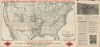

Map of the Texas and Pacific Railway and Connections. / The Texas and Pacific Railway The Short Line from Texas, Mexico and California to St. Louis, Memphis and All Points North and East. / The Texas and Pacific Railway The Direct Through Line from California, Colorado, and the West to Shreveport, New Orleans, Memphis and All Points in the Southeast.
One of the few railroads that received a federal charter.
- Digital Map Information
- Suitable for large format printing
- DPI: 600
- File Size: 72.4 MB
- File Type: ZIP / TIFF
- ICC color profile embedded
- Delivered instantly via download link
One of the few railroads that received a federal charter.
This is a 1911 Woodward and Tiernan railroad map of the United States illustrate the routes of the Texas and Pacific Railway, one of the few railroads established by federal charter. The Texas and Pacific Railway was a Congressional attempt at reviving a southern transcontinental railroad, only two years after the first transcontinental railroad was finished. The route of the Texas and Pacific is immediately identifiable in red, and the extensive U.S. railroad network is also illustrated.A Closer Look
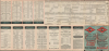
The map depicts nearly the entire continental United States, omitting northern Maine and the northernmost reaches along the Canadian border from Minnesota to Washington. Red lines mark the railway operated by the Texas and Pacific Railway between El Paso and Texarkana, Texas, and Shreveport and New Orleans, Louisiana. Bold black lines highlight the network of the Missouri Pacific Railroad (of which the Texas and Pacific was a subsidiary), which provides connections to Little Rock, Memphis, St. Louis, Kansas City, Omaha, Denver, Santa Fe, and Salt Lake City. Thinner black lines trace the rest of the extensive railroad network throughout the United States, with cities labeled from coast to coast. On the left, text extolls the benefits of moving to Texas, including cheap land, fertile soil, and 'plenty of elbowroom'. Timetables from April 1911 occupy the verso.The Texas and Pacific Railway
The Texas and Pacific Railway was established by a federal charter (the only such railroad in Texas and one of the few in the entire United States) on March 3, 1871, as the Texas Pacific Railway Company. The name was changed to the Texas and Pacific Railway Company by an Act of Congress on May 2, 1872. Created two years after the first Transcontinental Railroad was completed, Congress hoped that the Texas and Pacific could establish a southern transcontinental route from Marshall, Texas, to San Diego, California. The company received federal land grants of 20 sections of land per mile in California, 40 sections per mile in modern-day Arizona and New Mexico, and the state of Texas granted the railroad 20 sections per mile. The Texas and Pacific completed its first section of railroad between Marshall and Texarkana on December 28, 1873, and slowly continued expanding westward. Jay Gould, of the Missouri and Pacific Railroad, leased the Texas and Pacific in 1881. The Texas and Pacific reached Sierra Blanca in December 1881, a little over a month after the Southern Pacific reached Sierra Blanca from California.The Texas and Pacific had been granted rights as far west as El Paso, where it was supposed to connect with the Southern Pacific. The Southern Pacific continued building east without construction rights, which ended with an agreement between the two railroads that allowed the Texas and Pacific to operate on the Southern Pacific's tracks to El Paso but no farther west. The Texas and Pacific also forfeited its charter and franchises west of El Paso, which were awarded to the Southern Pacific.
Having been beaten west, the Texas and Pacific changed direction. It began building east and reached New Orleans on September 12, 1882. At its largest, the Texas and Pacific owned 1,982 miles of track, of which 1,109 miles were in Texas. The Missouri Pacific acquired a majority stake in the Texas and Pacific in 1928. The Texas and Pacific continued operating as an independent entity until it was finally merged into the Missouri Pacific system on October 15, 1876.
Publication History and Census
This map was created and published by the Woodward and Tiernan Printing Company for the Texas and Pacific Railway in April 1911. This is the only known cataloged example with an April 1911 timetable on the verso. However, an example of the map with a February 1911 timetable on the verso is part of the Cobb Digital Map Collection at the Texas General Land Office (GLO) Map Database.Cartographer
William Henry Woodward (December 11, 1834 - November 30, 1904) was an English-American printer and publisher based in St. Louis. Woodward was born in Hereford, England. He moved with his parents to the United States in 1841-2, when his father had a disagreement with the Church of England, and they moved to New Jersey, where he was ordained an Episcopal Minister. The family moved between churches in Pennsylvania, Michigan, and Wisconsin (1849 - 1851) before finally, in 1851-2, settling permanently in St. Louis. William Henry remained in Madison, where from 1849 to 1852, he apprenticed in the printing trade under Col. David Atwood, publisher of the Wisconsin Statesman. In St. Louis, he began his career in the printing trade at the Missouri Republican, then the main regional paper. He attained some success and leveraged his savings to purchase the printing concern of George H. Hanson. Woodward's establishment quickly gained a reputation for solid work promptly delivered. During the U.S. Civil War, Woodward was recruited into the Missouri Home Guard and saw active service under General. E.C. Pike, including during the invasion of Missouri by Confederate General Sterling Price in 1864. In 1868, James Tiernan (1838 - September 16, 1886), a former colleague from the Missouri Republican, joined the firm, after which the imprint changed to 'Woodward and Tiernan.' The business also moved to the intersection of Third and Pine. In 1872, William B. Hale joined the partnership, and the imprint was changed again, this time to 'Woodward, Tiernan and Hale.' The business moved again, this time to the intersection of Second and Locust. Hale retired in 1882, causing the firm's imprint to revert to 'Woodward and Tiernan.' Tiernan passed away in 1886, just as the firm was preparing to move into even larger quarters at 309-315 North Third Street. Woodward acquired Tiernan's shares and reorganized the firm as the 'Woodward and Tiernan Stock Company.' By 1900, the company operated as the 'Woodward and Tiernan Printing Company'. Under Woodward's management, the company grew into a major concern, employing around 800 people and operating several factories. Woodward died of a heart attack at the St. Louis Club in November 1904. The firm operated until 1966, and in its later years was known as the Woodward Printing Company. William Henry Woodward married Miss Maria K. Knight in December 1859, and the couple had thirteen children, five of whom died in infancy. Their eldest daughter preceded them in death as well. She died on August 20, 1889. Maria Woodward died on June 16, 1898. Woodward remarried on February 8, 1899, to Miss Laura Maria Bingham. Further Details...
Condition
Fair. Wear along original fold lines. Slight loss at a few fold intersections. Verso repairs to fold separations and at fold intersections. Old tape repairs on verso. Slight loss along margin not effecting map. Slight loss to text at right along centerfold.
References
Texas GLO Map Database and Store Cobb Digital Map Collection 95770 (February 1911).